Fernweh: Home
ExploreGuideDestinationsMy tripsMy trip
de|en
All Places & RegionsRound tripsNight trains in EuropeAll highlightsAbout FernwehFAQPrivacy PolicyImprint
Download on the App StoreGet it on Google Play
ExploreGuideDestinationsMy tripsMy trip
    • Neighborhoods & highlights
    • Recommendations
    • Tours
    • Eat & drink
    • Culture
    • Getting around
    • Accommodation
    • Plan trip
    • Round trips
    • Nearby
    Oistins

    Photo by Gavin Fregona on Pexels

    Barbados

    Oistins

    CityBeach

    Oistins is the main town of Christ Church parish on the south coast and Barbados' fishing hub.

    by Felix Gillen

    1. Home
    2. Destinations
    3. Barbados
    4. Southern
    5. Oistins
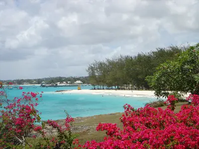
    Oistins is the main town of Christ Church parish on the south coast and Barbados' fishing hub. It's famous for its Fish Fry: on Friday evenings, locals and visitors gather at stalls where flying fish, tuna, mahi-mahi, and lobster are prepared, all to the rhythm of live music.Oistins is also historically significant: The Treaty of Oistins, which ended the struggles between the settlers and the English Commonwealth, was likely signed at Mermaid's Inn on January 17, 1652. Around Easter, the Oistins Fish Festival celebrates fishermen with boat races and fish-boning competitions. Very close by is Miami Beach, also called Enterprise Beach.
    Barbados travel guideSee the round tripPlan a trip with Oistins

    Contents

    • Neighborhoods & highlights
    • Recommendations
    • Tours
    • Eat & drink
    • Culture
    • Getting around
    • Accommodation
    • Round trips
    • Nearby

    Sights in Oistins

    Discover the most important sights and attractions

    Point of Interest

    1Oistins Fish Fry

    On the Oistins waterfront, wooden stalls prepare grilled and fried fish on Friday evenings: flying fish, tuna, mahi-mahi or lobster, with Macaroni Pie, plantains and salad. Bands play on a small stage, and Soca plays from the speakers. Lonely Planet says it kicks off around 7 PM; come early, as queues get long from 8 PM. Saturdays are a bit quieter.
    Open in Google Maps
    Beach

    2Miami Beach (Enterprise Beach)

    The beach is located just west of Oistins and is one of the bathing beaches near the fishing town on the south coast.
    Open in Google Maps

    Tours & experiences in Oistins

    Search tours for Oistins on GetYourGuide* (Affiliate link)On GetYourGuide, with reviews from other travellers

    * Affiliate link: if you book through it, we earn a small commission. The price stays the same for you.

    Restaurants in Oistins

    1

    Café Luna

    Restaurant on Enterprise Beach Road with views of Miami Beach. Fodor's highlights classic Bajan and tropical dishes, with gluten-free options.
    Show on Google Maps

    Fishers, Charter, and Fests

    The Charter of OistinsThe treaty that ended the fighting between the settlers of Barbados and the English Commonwealth was presumably signed at Mermaid's Inn in Oistins on January 17, 1652. This so-called Charter of Barbados secured rights for parliament and citizens.Oistins Fish FestivalAround Easter, the Fish Festival honours the Charter and the island's fishermen with boat races, fish-deboning competitions, and greasy pole climbing.

    Getting there and practical tips

    Getting thereOistins lies on the south coast in Christ Church, not far from the airport. Buses and ZR vans connect it with Bridgetown for a flat fare of BBD 3.50. After the fish fry, a taxi is the easiest way back; agree on the fare beforehand.Fish fry tipsFriday is the main night; Saturday is a little quieter.According to Lonely Planet things get going around 7pm, and queues grow long later in the evening.Busy festivals attract pickpockets; for current safety advice see the UK FCDO travel advice for Barbados.

    Accommodations in Oistins

    Find perfect stay in Oistins

    Booking.com* (Affiliate link)
    Search Hotels
    Agoda* (Affiliate link)
    Search Hotels
    Airbnb
    Vacation Rentals

    * Affiliate link: if you book through it, we earn a small commission. The price stays the same for you.

    Plan your trip to Oistins

    Save places, build a route and plan your city trip, all in one place.

    1. 1
      Sunrise over alpine peaks and a sea of clouds
      1234

      Round trip

      12 days · 4 stops

      Saved

      Pick a route

      Pick a ready-made one or save places and plan your own.

      Open bookmarks
    2. 2

      Trip to Oistins

      Live
      • 1Oistins Fish Fry3 days
      • 2Miami Beach (Enterprise Beach)4 days
      Budget

      Plan your trip

      The planner sorts stops, days and budget. Plan together in real time.

      Start trip planning
    3. 3
      9:41 No signal
      Oistins
      Available offline

      Photo by Gavin Fregona on Pexels

      Use it on the road

      Download the guide to your phone and use it on site, even offline.

    Round trips with Oistins

    Barbados around the island

    Barbados around the island

    Ten days to journey around Barbados by rental car. The routes are short, but roads are narrow and winding, and driving is on the left. For your rental car, you'll need a temporary driving permit, which you obtain from the rental company. Driving times are from the route planner rome2rio, assuming no traffic; distances are also according to Lonely Planet.

    10 Days
    7 stops

    Gregor Julien Straube·CC BY-SA 4.0

    Nearby

    Southern

    Southern

    The South Coast in Parish Christ Church is Barbados' most popular tourist area. It is home to Grantley Adams Airport, the entertainment district St. Lawrence Gap, and the fishing village Oistins, whose Friday night Fish Fry brings together locals and visitors.

    ROxBo·public domain

    Garrison

    Garrison

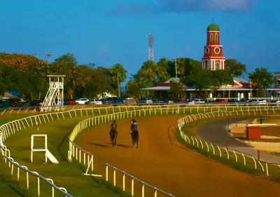
    The Garrison is the historic military district south of downtown Bridgetown and part of the UNESCO World Heritage site. According to UNESCO, St. Ann's Garrison is the earliest type of British naval and army base in the Caribbean.In the 18th and 19th centuries, it was home to the headquarters of the British West India Regiment. The focal point is the Garrison Savannah, a former parade ground spanning approximately twelve hectares, where horse races have been held since the 18th century. On November 30, 1966, Barbados' independence was celebrated here with the hoisting of the new flag. Surrounding the Savannah are the George Washington House, the Barbados Museum, housed in a former regimental building, the Main Guard with its clock tower, and St. Ann's Fort.

    Ulises Icardi·CC BY-SA 4.0

    Bridgetown

    Bridgetown

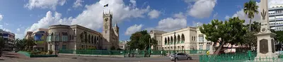
    Bridgetown is the capital of Barbados and is located on Carlisle Bay in the southwest of the island. Its old town with its winding alleys and the Garrison have formed the UNESCO World Heritage site “Historic Bridgetown and its Garrison” since 2011, bearing witness to trade and defense during the British colonial era.Founded in 1628, the city is bisected by the Careenage, a narrow waterway where ships were once refitted. Neo-Gothic Parliament Buildings front National Heroes Square, with shopping streets Broad Street and Swan Street to their north. Nearby are the 1654 Nidhe Israel Synagogue and St. Michael’s Cathedral. Just a few minutes south, Carlisle Bay offers calm, clear waters for snorkeling.

    Gregor Julien Straube·CC BY-SA 4.0

    Harrison's Cave

    Harrison's Cave is a dripstone cave in the island's limestone interior, in Parish St. Thomas, about eight kilometers from Bridgetown. You travel by tram past stalactites and stalagmites, underground streams and waterfalls.The cave is part of an eco-adventure park featuring a nature trail through tropical vegetation and an aviary with native birds. According to the tourism authority, tram tours operate on Mondays, Fridays, Saturdays, and Sundays between 10:30 AM and 2:30 PM; you should check availability online in advance.

    East Coast and Island Interior

    On the east coast, the Atlantic meets Barbados unchecked. Around Bathsheba in the Scotland District, rocks dot the surf, while surfers ride the waves at Soup Bowl. In the hilly island interior are Harrison's Cave, a stalactite cave, and Hunte's Gardens, a gorge garden. Not far away, Mount Hillaby rises as the island's highest point.

    Your next steps

    Oistins is in Barbados. Ways to carry on from here.

    • More in Barbados

      Highlights, areas, routes and the best time to travel for all of Barbados.

      Barbados travel guide
    • Round trips with Oistins

      One route passes through Oistins, with stops, nights and a map.

      See the round trip

    Sources & method

    • Photos: Pexels. Each photo carries its credit.
    • Place data such as addresses and ratings comes from Google Maps.
    • The content is based on web research from public, traceable sources. How the content is made · The role of AI