Fernweh: Home
ExploreGuideDestinationsMy tripsMy trip
de|en
All Places & RegionsRound tripsNight trains in EuropeAll highlightsAbout FernwehFAQPrivacy PolicyImprint
Download on the App StoreGet it on Google Play
ExploreGuideDestinationsMy tripsMy trip
    • Neighborhoods & highlights
    • Eat & drink
    • Culture
    • Getting around
    • Accommodation
    • Plan trip
    • Nearby
    Dumaguete

    Iampjanz / Wikimedia Commons / CC BY-SA 4.0, mod.

    Philippines

    Dumaguete

    City

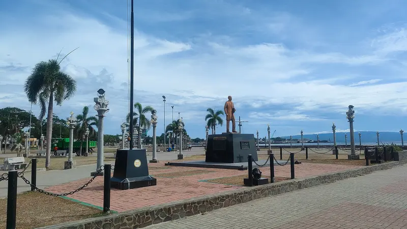
    Dumaguete is the university city on the southeast coast of Negros and a ferry port to Siquijor. On Rizal Boulevard, the waterfront promenade, José Rizal is said to have stopped on his way to exile in Dapitan.

    by Felix Gillen

    1. Home
    2. Destinations
    3. Philippines
    4. Dumaguete
    Dumaguete is the university city on the southeast coast of Negros and a ferry port to Siquijor. On Rizal Boulevard, the waterfront promenade, José Rizal is said to have stopped on his way to exile in Dapitan. The Silliman University, founded in 1901, with its campus, shapes the cityscape.Off the coast is Apo Island, a marine protected area co-founded by fishermen in 1982, teeming with sea turtles. In the hinterland, hiking trails lead to the twin lakes Balinsasayao and Danao in the rainforest, and to the Casaroro Falls.
    Philippines travel guideRound trips in PhilippinesPlan a trip with Dumaguete

    Contents

    • Neighborhoods & highlights
    • Eat & drink
    • Culture
    • Getting around
    • Accommodation
    • Nearby

    Sights in Dumaguete

    Discover the most important sights and attractions

    Attraction

    1Apo Island

    The marine sanctuary around Apo Island was established in 1982 by the island's fishermen with marine biologist Angel Alcala. More than 60 sea turtles have been counted here. From Malatapay in Zamboanguita, an outrigger boat trip takes about 35 minutes; a fee is charged for the sanctuary.
    Open in Google Maps
    Attraction

    2Rizal Boulevard

    The bayside promenade is Dumaguete's signature landmark. According to the provincial government, José Rizal is said to have stopped here on his way to exile in Dapitan.
    Open in Google Maps
    Museum

    3Silliman University Anthropology Museum

    The museum in Hibbard Hall of Silliman University, established 1901, shows ethnographic and archaeological collections from the region.
    Open in Google Maps
    Park

    4Casaroro Falls

    Accessible via a steep, long staircase, the waterfall in the highlands west of Dumaguete is a popular swimming spot.
    Open in Google Maps
    Natural Feature

    5Lake Balinsasayao

    One of the two twin lakes, Balinsasayao and Danao, in the mountain rainforest near Sibulan, a hiking destination in Dumaguete's hinterland.
    Open in Google Maps

    Restaurants in Dumaguete

    University and Sea Protection

    Silliman UniversitySilliman University was founded in 1901 and has been a university since 1938. It is considered Asia's first American and Protestant university. An Anthropological Museum in Hibbard Hall showcases ethnographic and archaeological collections.Apo IslandThe marine protected area around Apo Island was established in 1982 by the island's fishermen together with marine biologist Angel Alcala from Silliman University. Over 60 sea turtles have been counted there.

    Practical

    Getting ThereDumaguete has a domestic airport and a ferry port with connections to Siquijor (fast boat approximately 50 minutes) and other Visayas ports.ExcursionsTo Apo Island, travel from Malatapay in Zamboanguita by outrigger boat takes about 35 minutes; a fee is charged for the protected area.The twin lakes Balinsasayao and Danao are located in the highlands near Sibulan.Along the coast of Dauin, south of the city, old watchtowers stand from the time of the Moro raids.

    Accommodations in Dumaguete

    Find perfect stay in Dumaguete

    Booking.com* (Affiliate link)
    Search Hotels
    Agoda* (Affiliate link)
    Search Hotels
    Airbnb
    Vacation Rentals

    * Affiliate link: if you book through it, we earn a small commission. The price stays the same for you.

    Plan your trip to Dumaguete

    Save places, build a route and plan your city trip, all in one place.

    1. 1
      Sunrise over alpine peaks and a sea of clouds
      1234

      Round trip

      12 days · 4 stops

      Saved

      Pick a route

      Pick a ready-made one or save places and plan your own.

      Open bookmarks
    2. 2

      Trip to Dumaguete

      Live
      • 1Apo Island3 days
      • 2Rizal Boulevard4 days
      • 3Silliman University Anthropology Museum5 days
      Budget

      Plan your trip

      The planner sorts stops, days and budget. Plan together in real time.

      Start trip planning
    3. 3
      9:41 No signal
      Dumaguete
      Available offline

      Iampjanz / Wikimedia Commons / CC BY-SA 4.0, mod.

      Use it on the road

      Download the guide to your phone and use it on site, even offline.

    Nearby

    Siquijor

    Siquijor

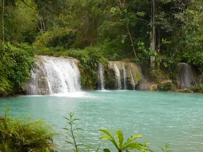
    Siquijor is a small island in the central Visayas, about 50 minutes by fast ferry from Dumaguete. It is known for its traditional healers, which Marco Polo lists as one of the country's typical experiences, and can be circumnavigated by scooter in a day.Along the way await the tiered pools of Cambugahay Falls, the cliffs at Salagdoong Beach, Paliton sunset beach, and in Lazi, a church built in 1884 with one of the largest convents from the Spanish era. Under an old Balete tree, fish nibble at your feet in a spring.

    Lawrence Ruiz·CC BY-SA 4.0

    Panglao

    Panglao, the island off Bohol's southwest tip, is the region's beach and diving hub, boasting over 70 dive centers and the bustling Alona Beach. Offshore, the Balicasag Marine Sanctuary features a drop-off and sea turtles.Flights for Bohol-Panglao International Airport have landed on Panglao since 2018. The Hinagdanan Cave with its underground lake can be explored by swimming.
    Moalboal

    Moalboal

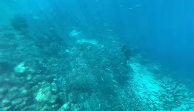
    Moalboal on Cebu's southwest coast is famous for the Sardine Run: Just a few meters off Panagsama Beach, millions of sardines swim in dense schools, accessible directly from the shore with mask and snorkel. The best visibility is early in the morning between 7 and 9 AM.Boat tours go to the offshore Pescador Island, in neighboring Badian are the Kawasan Falls, the endpoint of canyoning tours from Alegria. It takes three to four hours from Cebu City.

    Iampjanz·CC BY-SA 4.0

    Chocolate Hills

    Chocolate Hills

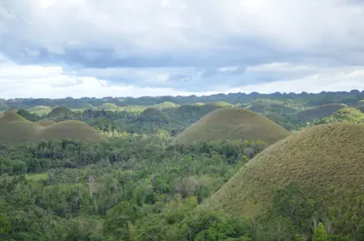
    The Chocolate Hills in central Bohol are more than 1,200 uniformly shaped limestone hills, spreading across approximately 50 square kilometers in the municipalities of Carmen, Batuan, and Sagbayan. During the dry season, the grass withers, coloring the hills chocolate brown, while in the rainy season, from June to November, they are green. Since 1988, they have been a national geological monument, today forming the core of the UNESCO Global Geopark Bohol.You get the classic view from the Chocolate Hills Complex in Carmen, about 55 kilometers from Tagbilaran. The light is most beautiful at sunrise or late afternoon.

    Jon Discipulo·Pexels

    Bohol

    Bohol

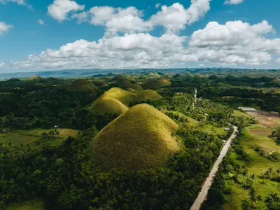
    Bohol in the central Visayas is the Philippines' first UNESCO Global Geopark since 2023. In the island's interior rise the Chocolate Hills, over 1,200 cone-shaped mounds that turn brown during the dry season. The Philippine Tarsier, one of the world's smallest primates, lives in the Corella sanctuary.Also featured are coral stone churches such as in Baclayon, boat trips on the Loboc River, and the diving areas off Panglao. Fast ferries connect Tagbilaran to Cebu in about two hours; flights land at Bohol-Panglao Airport.

    Geio Tischler·Unsplash

    Your next steps

    Dumaguete is in Philippines. Ways to carry on from here.

    • More in Philippines

      Highlights, areas, routes and the best time to travel for all of Philippines.

      Philippines travel guide
    • Round trips in Philippines

      Ready-made routes through Philippines, with stops, nights and a map.

      See the routes

    Sources & method

    • Photos: Wikimedia Commons. Each photo carries its credit.
    • Place data such as addresses and ratings comes from Google Maps.
    • The content is based on web research from public, traceable sources. How the content is made · The role of AI