Fernweh: Home
    ExploreTravel GuidesPlan a tripMy tripLast visited
    de|en
    All Places & RegionsAll highlightsAbout FernwehFAQPrivacy PolicyImprint
    ExploreTravel GuidesPlan a tripMy tripLast visited
    • Overview
    • Places in the region
    • Food culture
    • Best travel time
    • Culture
    • Getting around
    • Nearby
    Riviera Nayarit

    Mexico

    Riviera Nayarit

    Region

    Riviera Nayarit is the roughly 300 km long coastline of the state of Nayarit, stretching between the mouth of the Río Ameca near Nuevo Vallarta and the old port of San Blas.

    by Felix Gillen

    1. Home
    2. Destinations
    3. Mexico
    4. Riviera Nayarit
    Riviera Nayarit is the roughly 300 km long coastline of the state of Nayarit, stretching between the mouth of the Río Ameca near Nuevo Vallarta and the old port of San Blas. In the south, on Bahía de Banderas, are towns such as Bucerías and Punta de Mita; further north lie Sayulita, San Pancho, and Lo de Marcos, with surf beaches and small fishing villages. From December to March, humpback whales come into the bay.
    The region begins just north of Puerto Vallarta, its airport located only a few kilometers from the Nayarit border. Along Bahía de Banderas, large hotel resorts line Nuevo Vallarta and the Punta de Mita peninsula. North of there, Federal Highway 200 winds through forested hills to smaller towns: Sayulita has been a Pueblo Mágico since 2015 and is a well-known surf town, San Pancho is quieter, Lo de Marcos a fishing village with a long beach. Further north lies San Blas with its La Tovara mangroves.
    Lo de Marcos

    Place 1 of 4

    Lo de Marcos

    Lo de Marcos is a traditional fishing village on the Riviera Nayarit, north of San Pancho. Unlike Sayulita, the village is hardly geared towards tourism: You'll find a long sandy beach, simple fish restaurants and a quiet village life.

    Discover
    Punta de Mita

    Place 2 of 4

    Punta de Mita

    Punta de Mita is a peninsula on the northern edge of Bahía de Banderas, on the Riviera Nayarit north of Puerto Vallarta. Within these private grounds are luxury resorts like the Four Seasons and St. Regis, as well as two golf courses designed by Jack Nicklaus.

    Discover
    San Pancho (San Francisco)

    Place 3 of 4

    San Pancho (San Francisco)

    San Pancho, officially San Francisco, is a quiet village on the Riviera Nayarit, approximately 7 km north of Sayulita. The wide beach is significantly less visited than in Sayulita, but the surf can be strong.

    Discover
    Sayulita

    Place 4 of 4

    Sayulita

    Sayulita is a small surf town on Riviera Nayarit's Pacific coast, about 40 km north of Puerto Vallarta airport. Come for the consistent main beach waves, perfect for surf lessons, and the relaxed town center with beachside bars and galleries.

    Discover

    Sights in Riviera Nayarit

    Discover the most important sights and attractions

    Playa del Amor (Islas Marietas)
    Park

    Playa del Amor (Islas Marietas)

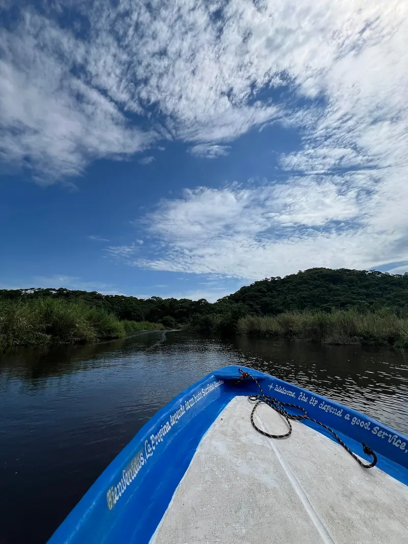
    The beach lies within a collapsed grotto on the Marietas Islands, about 8 km off Punta de Mita. The islands have been a National Park since 2005; visitor numbers are limited, and access is only with licensed boat operators.
    Open in Google Maps
    La Tovara
    Park

    La Tovara

    Explore the mangrove area near San Blas in the north of the Riviera Nayarit by boat, traveling through narrow canals to a freshwater spring. Along the way, you'll see crocodiles, turtles, and herons. Since 2008, La Tovara has been designated as a Ramsar wetland of international importance.
    Open in Google Maps

    Food and Drink on the Riviera Nayarit

    Nayarit's cuisine thrives on fish and shrimp, with many recipes originating from the lagoon landscape in the north of the state.

    Pescado zarandeado

    Butterflied fish, marinated and charcoal-grilled in a grate. Its origin is attributed to the island settlement of Mexcaltitán in northern Nayarit.

    Tlaxtihuilli

    Soup made with shrimp and chili, thickened with corn dough.

    Nayarit-style Ceviche

    Finely chopped fish, cooked in lime juice and mixed with carrot, tomato, and onion.

    Salsa Huichol

    Hot chili sauce, made in Tepic since 1949 and found on almost every table along the coast.

    Best Time to Visit

    When is the best time for your trip?

    November
    December
    January
    February
    March
    April
    22–25°C·2–34 mm(little rain)
    From November to April, it barely rains, the days are warm and the nights pleasant. From early December to late March, humpback whales can be found in Bahía de Banderas, which is also when most visitors arrive.
    Values are from Puerto Vallarta, at Bahía de Banderas' south end, and apply well to Riviera Nayarit's coastal towns. Most rain falls June to October, often as heavy afternoon or nighttime showers. This period is also Pacific hurricane season; monitor reports before and during your trip.

    Seasons

    Jan
    Feb
    Mar
    Apr
    May
    Jun
    Jul
    Aug
    Sep
    Oct
    Nov
    Dec
    Dry season
    High season and whale season
    Wet season
    Best Time to Visit
    ▶Show detailed monthly data
    MonthTemp (°C)Rain (mm)Sun (h)
    January21.7347.0
    February21.758.0
    March22.228.0
    April23.628.0
    May25.6158.0
    June28.31887.0
    July28.63286.0
    August28.33126.0
    September28.33706.0
    October27.8947.0
    November25.3207.0
    December22.8236.0

    Culture and Outings

    Villages Between Sea and SierraUntil the 1960s, many places in Riviera Nayarit were small fishing and farming villages; tourism arrived only with the coastal road. In the galleries of Sayulita and other towns, you'll see yarn and bead art by the Wixárika (Huichol) people, who live in the mountains of Nayarit and Jalisco. San Pancho fosters a vibrant village life with its community center EntreAmigos and its own cultural festivals.ExcursionsIslas Marietas: The uninhabited islands approx. 8 km off Punta de Mita have been a National Park and a nesting site for blue-footed boobies since 2005. Playa del Amor can only be visited with licensed tour operators.San Blas and La Tovara: From the old port of San Blas, boat tours lead through the mangroves of La Tovara to a freshwater spring. En route, you'll see crocodiles and waterbirds.Whale Watching: From early December to late March, boats depart from Punta de Mita, La Cruz de Huanacaxtle, and Nuevo Vallarta to see humpback whales.

    Traveling on the Riviera Nayarit

    The Puerto Vallarta airport is located right on the border with Nayarit and is the main point of arrival. From there, Highway 200 runs along the coast to Bucerías and continues over the hills to Sayulita, San Pancho, and Lo de Marcos. You can reach Punta de Mita via a dedicated road along the bay.Regional buses heading towards Compostela depart from Puerto Vallarta and stop in the towns along Highway 200. You'll be more flexible with a rental car or taxi. For current safety and health information, check the UK FCDO Travel Advice for Mexico.

    Nearby

    Sayulita

    Sayulita

    Sayulita is a small surf town on Riviera Nayarit's Pacific coast, about 40 km north of Puerto Vallarta airport. Come for the consistent main beach waves, perfect for surf lessons, and the relaxed town center with beachside bars and galleries. Since 2015, Sayulita bears the title Pueblo Mágico; surfers have been coming here since the 1960s.
    San Pancho (San Francisco)

    San Pancho (San Francisco)

    San Pancho, officially San Francisco, is a quiet village on the Riviera Nayarit, approximately 7 km north of Sayulita. The wide beach is significantly less visited than in Sayulita, but the surf can be strong. The town is known for its community projects such as the EntreAmigos Cultural Center and a children's circus school.
    Lo de Marcos

    Lo de Marcos

    Lo de Marcos is a traditional fishing village on the Riviera Nayarit, north of San Pancho. Unlike Sayulita, the village is hardly geared towards tourism: You'll find a long sandy beach, simple fish restaurants and a quiet village life.
    Punta de Mita

    Punta de Mita

    Punta de Mita is a peninsula on the northern edge of Bahía de Banderas, on the Riviera Nayarit north of Puerto Vallarta. Within these private grounds are luxury resorts like the Four Seasons and St. Regis, as well as two golf courses designed by Jack Nicklaus. In the town itself, fish and beach restaurants line Avenida El Anclote, and from here boats also depart for the Islas Marietas.
    Puerto Vallarta

    Puerto Vallarta

    Puerto Vallarta is a port and resort city of around 220,000 residents on Jalisco's Pacific coast, on Bahía de Banderas at the foot of the Sierra Madre Occidental. You come for the beaches, the Malecón boardwalk with its sculptures, and the Old Town, its whitewashed houses ascending the hillside around the Church of Nuestra Señora de Guadalupe. South of the Río Cuale is the Zona Romántica, home to Playa Los Muertos, the city's largest public beach.

    Sources & method

    • Photos: Wikimedia Commons, Pexels. Each photo carries its credit.
    • Place data such as addresses and ratings comes from Google Maps.
    • The content is based on web research from public, traceable sources. How the content is made · The role of AI