Fernweh: Home
ExploreGuideDestinationsMy tripsMy trip
de|en
All Places & RegionsRound tripsNight trains in EuropeAll highlightsAbout FernwehFAQPrivacy PolicyImprint
Download on the App StoreGet it on Google Play
ExploreGuideDestinationsMy tripsMy trip
    • Neighborhoods & highlights
    • Tours
    • Eat & drink
    • Culture
    • Getting around
    • Accommodation
    • Plan trip
    • Nearby
    Jarabacoa

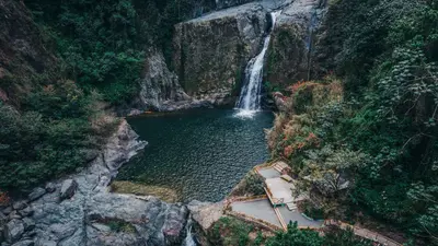
    Photo by Alberto Guzman on Pexels

    The Dominican Republic

    Jarabacoa

    City

    Jarabacoa, situated at around 530 m in the Cordillera Central, is called the "City of Eternal Spring" due to its mild climate.

    by Felix Gillen

    1. Home
    2. Destinations
    3. The Dominican Republic
    4. Cibao and Cordillera Central
    5. Jarabacoa
    Jarabacoa, situated at around 530 m in the Cordillera Central, is called the "City of Eternal Spring" due to its mild climate. Pine forests, coffee fields, and rivers define the surroundings: A path through the forest leads to Salto de Baiguate, rafting takes place on the Río Yaque del Norte, and hikers depart from here for Pico Duarte. The neighboring town of Constanza, gateway to Valle Nuevo National Park, lies at around 1,200 m.
    The Dominican Republic travel guideRound trips in The Dominican RepublicPlan a trip with Jarabacoa

    Contents

    • Neighborhoods & highlights
    • Tours
    • Eat & drink
    • Culture
    • Getting around
    • Accommodation
    • Nearby

    Sights in Jarabacoa

    Discover the most important sights and attractions

    Point of Interest

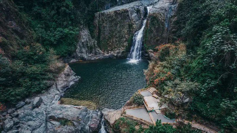
    1Salto de Baiguate

    Waterfall south of Jarabacoa, accessible by forest paths; many visitors go on horseback.
    Open in Google Maps
    Attraction

    2Jimenoa Waterfall

    The about 40 m high Jimenoa Dos waterfall lies northwest of Jarabacoa. The suspension bridges on the final stretch collapsed in 2018 during a storm; access remained closed in 2022, with no known reopening date. Ask locally for the current status.
    Open in Google Maps

    Tours & experiences in Jarabacoa

    Search tours for Jarabacoa on GetYourGuide* (Affiliate link)On GetYourGuide, with reviews from other travellers

    * Affiliate link: if you book through it, we earn a small commission. The price stays the same for you.

    Restaurants in Jarabacoa

    Climate & Nature

    Eternal SpringJarabacoa is located at around 530 m and is significantly cooler than the coast. Constanza, at around 1,200 m, is even cooler; in Valle Nuevo National Park above Constanza, temperatures can drop below 0 °C. Cloud forest with tree ferns grows there, and access requires a 4x4 vehicle.Rivers and WaterfallsThe Río Yaque del Norte flows through Jarabacoa, where rafting is offered. Nearby are the Baiguate and Jimenoa waterfalls; access to Jimenoa Dos was recently closed after the collapse of the suspension bridges.

    Getting There & Around

    Getting ThereCaribe Tours runs from Santo Domingo to Jarabacoa and La Vega. By car, take the Autopista Duarte (Route 1) towards La Vega and turn off into the mountains there.Pico DuarteThe ascent to the highest peak in the Caribbean starts in La Ciénaga, west of Jarabacoa; plan three days.

    Accommodations in Jarabacoa

    Find perfect stay in Jarabacoa

    Booking.com* (Affiliate link)
    Search Hotels
    Agoda* (Affiliate link)
    Search Hotels
    Airbnb
    Vacation Rentals

    * Affiliate link: if you book through it, we earn a small commission. The price stays the same for you.

    Plan your trip to Jarabacoa

    Save places, build a route and plan your city trip, all in one place.

    1. 1
      Sunrise over alpine peaks and a sea of clouds
      1234

      Round trip

      12 days · 4 stops

      Saved

      Pick a route

      Pick a ready-made one or save places and plan your own.

      Open bookmarks
    2. 2

      Trip to Jarabacoa

      Live
      • 1Salto de Baiguate3 days
      • 2Jimenoa Waterfall4 days
      Budget

      Plan your trip

      The planner sorts stops, days and budget. Plan together in real time.

      Start trip planning
    3. 3
      9:41 No signal
      Jarabacoa
      Available offline

      Photo by Alberto Guzman on Pexels

      Use it on the road

      Download the guide to your phone and use it on site, even offline.

    Nearby

    Cibao and Cordillera Central

    Cibao and Cordillera Central

    The interior is the green counterpart to the coast: In the fertile Cibao Valley lie Santiago de los Caballeros and La Vega, the strongholds of carnival, south of which the Cordillera Central rises. Jarabacoa at around 530 m is the starting point for waterfalls and rafting tours on the Río Yaque del Norte, from La Ciénaga, a multi-day trail leads to Pico Duarte, the Caribbean's highest peak.

    Alberto Guzman·Pexels

    Santiago de los Caballeros

    Santiago de los Caballeros

    Santiago de los Caballeros in the Cibao Valley is located about two hours' drive north of Santo Domingo on the Autopista Duarte. With the wealth of the tobacco family León Jimenes, the Centro León was established here, a cultural center featuring Dominican art and pre-Columbian archaeology; above the city rises the Monumento a los Héroes de la Restauración. In February, Santiago celebrates one of the country's largest carnivals after La Vega.

    Phyrexian·CC BY-SA 4.0

    Pico Duarte

    Pico Duarte in the Cordillera Central is the highest peak in the Caribbean; its official height is 3,087 m, though recent GPS measurements indicate 3,098 to 3,101 m. The usual ascent begins in La Ciénaga, home to the administration of Armando Bermúdez National Park, and leads 23 km with almost 2,000 meters of elevation gain to the summit. Most visitors plan three days, including overnight stays in the huts of La Compartición, about five kilometers below the peak. At night, frost can occur up there.
    Northcoast

    Northcoast

    The Atlantic north coast stretches from Puerto Plata, with its Spanish fortress and Amber Museum, through Sosúa, to Cabarete, one of the most famous kitesurfing spots in the Caribbean. Inland, visitors climb the cascades of the 27 Charcos de Damajagua. West of Puerto Plata lie the remains of La Isabela, founded by Columbus in 1493.

    William Finn·Pexels

    Cabarete and Sosúa

    Cabarete and Sosúa

    Cabarete, east of Puerto Plata, is the water sports hub of the North Coast: According to the Ministry of Tourism, sufficient wind for kiting blows here 250 to 300 days a year. At Kite Beach, you'll find almost flat water inside, and waves at the outer reef; the bay in front of town is shared by kiters and windsurfers, while at the mouth of the Río Yásica in La Boca, there's flat water among mangroves. Playa Encuentro, west of town, is considered the country's best surf spot. In the neighboring town of Sosúa, small restaurants line the water.

    Aneudy Caceres·Pexels

    Your next steps

    Jarabacoa is in The Dominican Republic. Ways to carry on from here.

    • More in The Dominican Republic

      Highlights, areas, routes and the best time to travel for all of The Dominican Republic.

      The Dominican Republic travel guide
    • Round trips in The Dominican Republic

      Ready-made routes through The Dominican Republic, with stops, nights and a map.

      See the routes

    Sources & method

    • Photos: Pexels. Each photo carries its credit.
    • Place data such as addresses and ratings comes from Google Maps.
    • The content is based on web research from public, traceable sources. How the content is made · The role of AI