Round trip · Peru
Rainforest and Sacred Valley: Tambopata, Machu Picchu and Cusco
by Felix Gillen
- 13 Days / 12 Nights
- Lima → Cusco
After a night in Lima, you fly just over an hour and a half to Puerto Maldonado and continue by boat, or by road and boat, to a lodge on the Tambopata River. A nonstop flight of about 50 minutes then takes you to Cusco, where you skip the city for now and drive about an hour down into the Sacred Valley. From Ollantaytambo, the train takes just under two hours to Aguas Calientes and Machu Picchu, and only at the end do you spend three nights in Cusco. The order is deliberate: in the highlands you first sleep between roughly 2,000 and 3,000 meters (6,500 to 9,800 feet) and reach Cusco, at 3,400 meters (11,200 feet), only once your body has adjusted to the altitude.
At a glance
- Duration
- 13 Days / 12 Nights
- Stops
- 6 · Lima → Cusco
- Arrival
- Flight · Lima (LIM)
- Departure
- Flight · Cusco (CUZ)
- Best Time to Go
- May to October: During this dry season, there is less rain in the Tambopata region, paths and river trips are easier, and it's mostly dry in the Highlands too. From November to April is the rainy season
More on when to go
In the rainforest, about 80 percent of annual precipitation falls then, and in the Sacred Valley, it rains mostly in the afternoons from December to April. From January to April, trains between Cusco and Machu Picchu often only run combined with buses.
6 stops
Why This Route?
This route links Peru's Amazon lowlands with the great Inca sites, using only short flights. Because you stay in the lower Sacred Valley first after the rainforest and save Cusco for last, you gain altitude gradually. For travelers who want wildlife as well as Machu Picchu, it is the alternative to the long bus journey through the south.
Hidden Gems
- At Lago Sandoval, head out at sunrise or in the hours before sunset, when giant otters and birds are most active
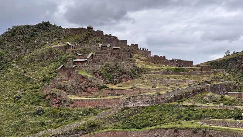
- In Pisac, walk down from the ruins to the village, the path across the terraces takes one and a half to two hours and ends at the marketplace
- In the Sacred Valley, combine the Maras salt terraces with the circular experimental terraces of Moray, which are only about six kilometers apart
Getting there and back
Open jaw: start and end are in different places
- Arrival
- Flight · Lima (LIM)From Jorge Chávez Airport, Miraflores is just under an hour to over 90 minutes away, depending on traffic; use an official airport taxi or a pre-booked transfer. For your next-morning flight to Puerto Maldonado you can also choose a hotel near the airport. Before you travel, check the FCDO travel advice for vaccinations and health risks in the Amazon lowlands and at high altitude, and get travel health advice.
- Departure
- Flight · Cusco (CUZ)Cusco Airport is roughly 30 minutes from the city center. From there, fly about 1.5 hours to Lima and connect to your home flight; plan several hours' buffer between flights.
Itinerary
Lima
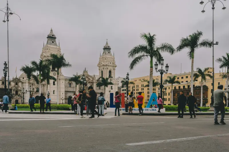
Peru's capital lies on the Pacific coast and is the first stop for most travelers. Francisco Pizarro founded it in 1535; as the seat of the Viceroyalty, it became Spanish South America's most important city. Its historic center, with its cathedral, monasteries, and wooden balconies, has been a UNESCO World Heritage site since 1988.For travelers, three districts are particularly important: the Centro Histórico with Plaza Mayor and the San Francisco Monastery, Miraflores with the Malecón along the cliffs and the adobe pyramid Huaca Pucllana, and Barranco, the bohemian district with galleries, murals, and the Puente de los Suspiros. In the Pueblo Libre district, the Museo Larco displays one of the country's great collections of pre-Columbian art.
Arrival night after the long-haul flight; in the evening, ceviche in Miraflores or Barranco.
3 Sights
3 Restaurants
Culture
Culinary CapitalIn Lima, Spanish, indigenous, African, Chinese, and Japanese influences converge, and nowhere is this more evident than on your plate. Here, you eat ceviche for lunch; Chifa is Peruvian-Chinese cuisine, Nikkei the Peruvian-Japanese.Colonial HeritageThe Spanish founded Lima in 1535 as the capital of their Viceroyalty. The old town, with its wooden balconies, monasteries, and churches, is now a UNESCO World Heritage site.Museums and ArtThe Museo Larco displays pre-Columbian ceramics spanning millennia; in Barranco, galleries and murals shape the streetscape. Those who want to hear Peruvian music go to a Peña in the evening.
Tambopata National Reserve
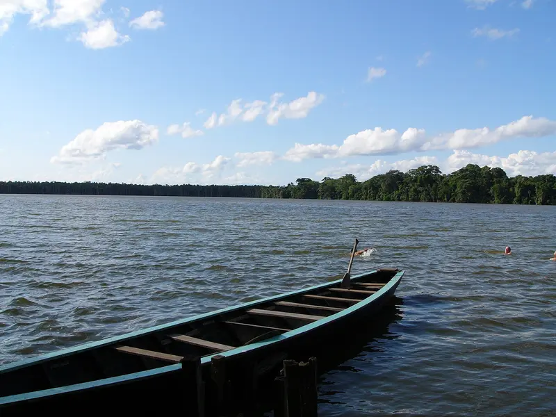
The Tambopata National Reserve protects Amazon rainforest south of Puerto Maldonado and is the most easily accessible rainforest area in Southern Peru. Accommodations are lodges on the Tambopata and Madre de Dios rivers, which organize guided excursions, usually as multi-day packages.Lago Sandoval: an oxbow lake about 15 kilometers from Puerto Maldonado, which you explore by rowboat after a boat trip and a walk. Birds, monkeys, and caimans are often spotted en route.Clay Licks (Collpas): On riverbanks, parrots and macaws gather early in the morning to eat mineral-rich clay. The Collpa Chuncho is accessible by an early boat trip.An entrance fee is required for the reserve, which is often not included in the tour price.
Flight to Puerto Maldonado in just over an hour and a half, then 45 minutes to about three hours by boat, or road and boat, depending on the lodge. Three nights allow for an early-morning macaw clay lick and Lake Sandoval with its giant otters.
1 Sight
Protected Area with Clay Licks
A Reserve Since 2000The Reserva Nacional Tambopata was established in September 2000 and covers 274,690 hectares south of the Río Madre de Dios. Among the recorded species are 632 bird species, around 1,200 butterfly species, and 169 mammal species. The reserve is managed by the protected area authority SERNANP, and most visitors arrive with authorized agencies.Collpas: The Clay LicksErosion exposes mineral-rich clay walls along the riverbanks. Parrots and macaws gather there, with the most activity early in the morning. Clay licks in the forest attract peccaries and tapirs at night.Travel Only by BoatThe starting point is Puerto Maldonado; you reach the reserve by boat via the Tambopata. Current health and safety information can be found at the Auswärtiges Amt, linked on the country page.
Sacred Valley of the Incas
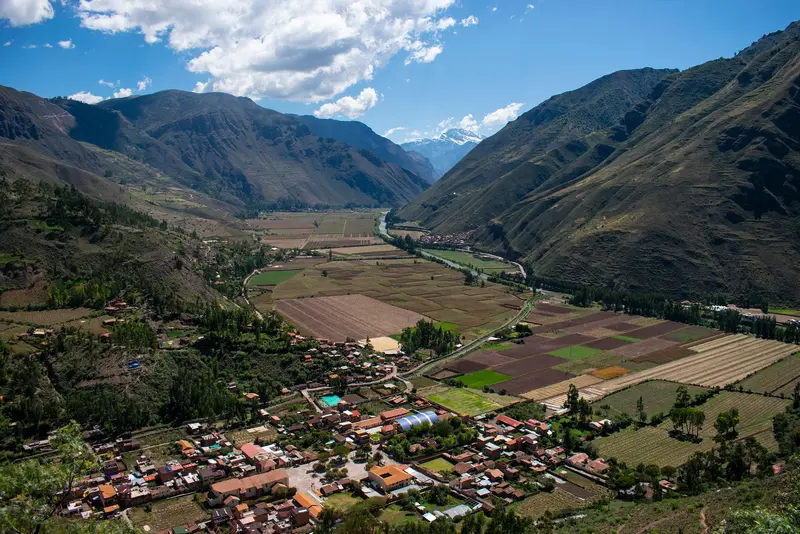
The Sacred Valley follows the Río Urubamba northwest of Cusco and was an important agricultural region for the Inca. The town of Pisac is located about 30 kilometers from Cusco, known for its handicraft market, especially on Sundays, and the terraces and temples of the Inca site on the mountain above the town.On the high plateau above the valley are the circular terraces of Moray, which the Inca presumably used for agricultural experiments, and the salt pans of Maras, where salt still evaporates from a spring today. At the western end of the valley lies Ollantaytambo, with the train station to Machu Picchu.Pisac, Ollantaytambo, Moray, and Chinchero are included in Cusco's Boleto Turístico.The valley lies lower than Cusco and is well-suited for the first days of acclimatization.
Nonstop flight to Cusco in about 50 minutes, then straight down to Pisac or Urubamba, about an hour away at just under 3,000 meters (9,800 feet). Pisac, Maras, Moray and the Chinchero market.
5 Sights
Culture and History of the Sacred Valley
The Valley of the IncasThis refers to the section of the Río Urubamba featuring Pisac, Chinchero, Maras, Urubamba, and Ollantaytambo. Thanks to its climate and fertile soil, the valley was a vital agricultural hub during the Inca Empire's golden age. Pisac is considered the royal estate of Inca Pachacútec, while the palaces of Chinchero were built by Inca Túpac Yupanqui.Markets and Living TraditionsIn many villages, Quechua is still spoken today, and women process alpaca wool using traditional dyeing and weaving techniques. On Sundays, large markets are held in Pisac and Chinchero, selling handicrafts, textiles, indigenous potatoes, and Andean grains.Boleto TurísticoThe Inca sites of Pisac, Ollantaytambo, Chinchero, and Moray are included in the Boleto Turístico del Cusco (Circuit III). According to the fare schedule of the operator COSITUC, foreign visitors pay:Boleto Integral (all three circuits in and around Cusco, valid for 10 days): 130 SolesBoleto Parcial Circuito III (Sacred Valley only, valid for 2 days): 70 SolesThe Salineras de Maras and Machu Picchu are not included and require separate tickets.
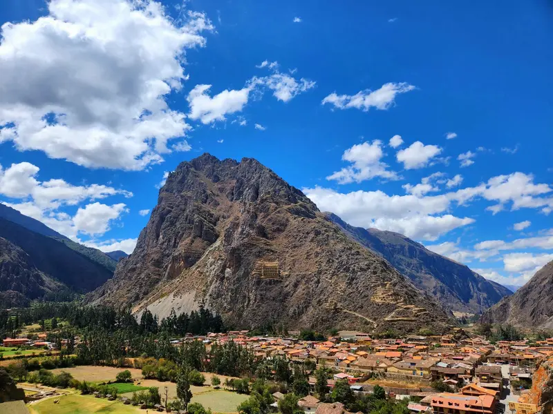
Ollantaytambo
Ollantaytambo is situated at approximately 2,800 meters at the western end of the Sacred Valley. The town is often referred to as a living Inca village: Its old town still follows the rectilinear street grid of the Inca, water flows through the alleys in stone channels, and many houses stand on Inca walls.Above the town rise the Inca terraces and temple complexes, which were expanded under Pachacútec. During the Spanish conquest, Ollantaytambo served as a fortress for Manco Inca. On the opposite slope lie ancient storage structures.From the station, PeruRail and Inca Rail run several times daily to Aguas Calientes; the journey takes about two hours.The Inca site is included in Cusco's Boleto Turístico.
At about 2,800 meters (9,200 feet), the lowest overnight stop in the valley. The Inca fortress in the afternoon, the train to Aguas Calientes the next morning.
2 Sights
3 Restaurants
History and Culture of Ollantaytambo
Grid-Pattern Inca CityAround the mid-15th century, Inca Pachacútec conquered the site and rebuilt it as part of his estate, complete with terraces and irrigation canals. The settlement follows a rectangular grid of four longitudinal and seven cross streets. The Kanchas, walled courtyards with rooms around an inner courtyard, and the water channels in the alleys remain preserved and inhabited to this day.Quarry and ResistanceThe Incas quarried the pink rhyolite for the Sun Temple from Kachiqhata, about 5 km away on the other side of the river. After the Spanish conquest, Ollantaytambo served as a refuge for Manco Inca. On the plain below the terraces, he defeated a Spanish army led by Hernando Pizarro, before retreating to Vilcabamba.LocationThe site is located at about 2,800 m in the Sacred Valley, approximately 72 km northwest of Cusco.
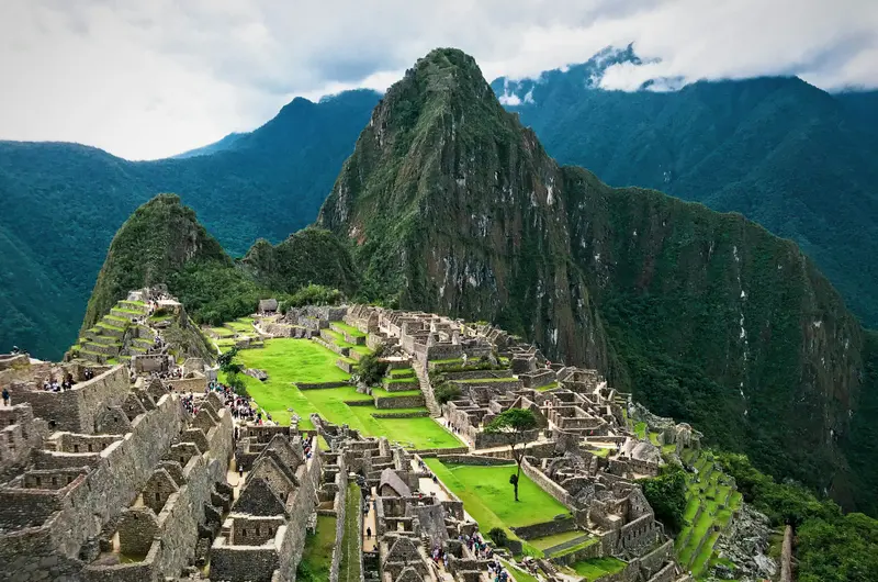
Machu Picchu
Machu Picchu is the most famous Inca site and the reason why most travelers come to Peru. The complex is located at an altitude of about 2,430 meters on a mountain ridge between the peaks of Machu Picchu and Huayna Picchu, high above the Río Urubamba, approximately 80 kilometers northwest of Cusco. Most archaeologists consider it an estate of the Inca ruler Pachacútec, built around 1450. It remained hidden from the Spanish, gaining international recognition in 1911 through Hiram Bingham. Since 1983, it has been a UNESCO World Heritage site.Tickets: Admission is divided into three circuits with a total of ten routes and fixed entry times. The daily capacity is 4,500 visitors, increasing to 5,600 on designated high-season days. Tickets are sold online by the Ministry of Culture at tuboleto.cultura.pe. As of September 2026, reservations are no longer required; immediate payment is implemented. A small contingent for the following day is available on-site in Aguas Calientes. Book early for June to October.Getting there: By train from Cusco or Ollantaytambo to Aguas Calientes, then by bus or on foot via stairs up to the entrance.Inca Trail: The classic trail requires a permit obtained through a licensed tour operator and is typically closed for maintenance in February.
Just under two hours by train from Ollantaytambo; overnight in Aguas Calientes at about 2,000 meters (6,700 feet). The shuttle bus takes 25 to 30 minutes to the ruins, with the first departures around 5:30 a.m.
3 Sights
History of Machu Picchu
Built by PachacútecThe Inca city arose in the 15th century by order of Inca Pachacútec. It sits on a steep ridge at around 2,430 m, where the Andes meet the Amazon Basin. Its roughly 200 structures served religious, ceremonial, astronomical, and agricultural purposes; a large plaza separates the agricultural from the residential zone. The city was abandoned after the 16th-century Spanish conquest.Rediscovery in 1911On July 24, 1911, US researcher Hiram Bingham reached the ruins on behalf of Yale University. Local farmers knew the site beforehand; Agustín Lizárraga had visited it already in 1902. Over 46,000 artifacts went to Yale for cataloging; 363 pieces returned to Peru in 2011.Protection and Recognition1981: Declared a Historical Sanctuary (Santuario Histórico)1983: Listed on the UNESCO World Heritage List as a mixed cultural and natural heritage site2007: Voted one of the New Seven Wonders of the World
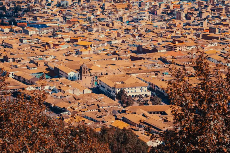
Cusco
Cusco was the capital of the Inca Empire and is today the starting point for almost every trip to Machu Picchu. Under Pachacútec, a planned city with religious and administrative areas was developed. The Spanish retained the layout, building their churches and palaces on the Inca walls. Since 1983, the city has been a UNESCO World Heritage site.The heart of the city is the Plaza de Armas, home to its cathedral and arcades. The Santo Domingo Convent stands on the Qorikancha, the Inca Sun Temple, whose walls are still visible. On Calle Hatun Rumiyoc sits the famous Twelve-Angled Stone, above which is the artisan quarter San Blas. The Mercado San Pedro is the city's most important market. Above the city lies the Inca site Sacsayhuamán with its mighty stone walls, setting for Inti Raymi on June 24.Cusco is at around 3,400 meters: Take it easy for the first few days.For Sacsayhuamán and the Inca sites in the Sacred Valley, you'll need the Boleto Turístico, available as a ten-day comprehensive ticket or partial tickets. Qorikancha and the Cathedral are not included.
A little over three hours by train to Poroy or San Pedro. Now well acclimatized: Inca walls, Qorikancha, San Blas and Sacsayhuaman.
7 Sights
4 Restaurants
Culture
Navel of the WorldQosqo means roughly Navel in Quechua, and that is exactly what the city was for the Inca: the center of their empire. The Spanish built their churches and palaces directly on the seamless Inca walls, which you can still see on many street corners today. The old town is a UNESCO World Heritage site.Living TraditionsYou hear Quechua everywhere in Cusco, in the markets as well as in the surrounding villages. Every year on June 24th, the city celebrates Inti Raymi, the Inca Festival of the Sun, with a grand staging in Sacsayhuamán.Art and CraftThe Cusqueña School of Painting shaped the colonial art of the Andes; many churches in the city are filled with their paintings. In San Blas, artisans still work in small workshops today.
Plan this route as your trip
All stops, trains and nights go into your trip planner. You adjust dates and places to stay afterwards.
This route is a suggestion from our research. Please check timetables, times in port, opening hours and prices before you book – what your tour operator or carrier says is what counts.
Fernweh is a free travel guide and trip planner: routes researched by people, taken over in one click, used day by day on the road. More about Fernweh
6 stops
Route Summary
Duration13 Days
Stops6 Places
TypeMixed