Fernweh: Home
    ExploreTravel GuidesPlan a tripMy tripLast visited
    de|en
    All Places & RegionsAll highlightsAbout FernwehFAQPrivacy PolicyImprint
    ExploreTravel GuidesPlan a tripMy tripLast visited
    Mission Beach

    Australia

    Mission Beach

    Coastal Town

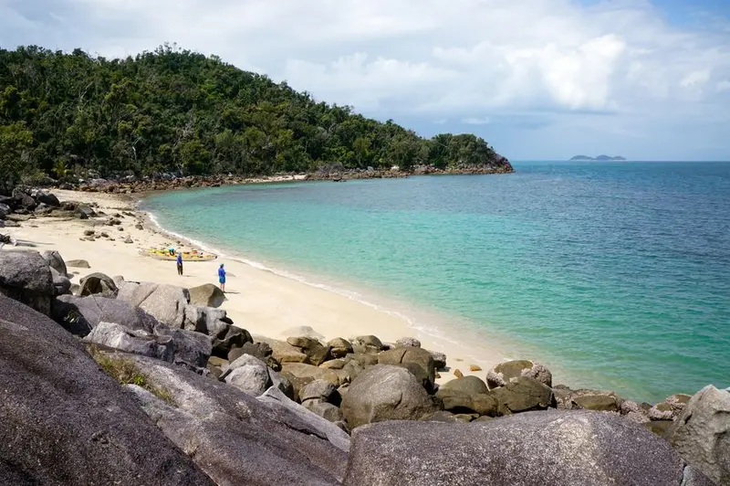
    Four small towns on a roughly 14-kilometer long beach between Cairns and Townsville. The rainforest almost reaches the water, and Dunk Island lies off the coast.

    by Felix Gillen

    1. Home
    2. Destinations
    3. Australia
    4. Tropical North Queensland
    5. Mission Beach
    Four small towns on a roughly 14-kilometer long beach between Cairns and Townsville. The rainforest almost reaches the water, and Dunk Island lies off the coast. It's quieter here than in Cairns or Port Douglas, and with a bit of luck, you'll spot cassowaries by the roadside.

    Sights

    Discover the most important sights and attractions

    Lacey Creek Walk (Djiru National Park)

    Lacey Creek Walk (Djiru National Park)

    Short loop walk through lowland rainforest at Lacey Creek. The trail is flat and well-maintained; cassowaries are often spotted here. Keep your distance, as the birds can be dangerous.
    Open in Google Maps
    Bicton Hill Walking Track

    Bicton Hill Walking Track

    Loop trail through rainforest to Bicton Hill near Clump Point. Along the way, you'll see views of the coast and the islands off Mission Beach. Some sections are steep, allow about one and a half hours.
    Open in Google Maps

    Licuala Fan Palm Walk

    A short walk through a forest of Licuala fan palms in Djiru National Park. Their large, round leaves form a dense canopy over the path.
    Open in Google Maps

    Big Cassowary

    Big Cassowary Statue in Wongaling Beach, one of Australia's typical "Big Things." Short photo stop on the way through town.
    Open in Google Maps

    Restaurants & Cafés

    Bingil Bay Cafe

    Colourful café in Bingil Bay at the northern end of the coast. Breakfast, lunch and coffee, with views across the road to the sea.
    Show on Google Maps

    Food & Drink

    The selection is small and relaxed. Many kitchens close around 8 or 9 PM.

    Equatorial Fruits

    Bananas, papayas, and mangoes grow locally. You often buy them direct from the farm at roadside stands.

    Fish and Seafood Selections

    Barramundi and prawns are on most menus. For a beach picnic, grab some fish and chips to take away.

    Culture and History

    Land of the DjiruThe coast around Mission Beach is Djiru Country. The town's name harks back to the Hull River Aboriginal Settlement, a settlement founded in 1914 where Aboriginal people from the region were forcibly relocated. A cyclone destroyed it in 1918.Cyclones and CassowariesCyclones Larry in 2006 and Yasi in 2011 hit the area hard. Since then, the forest has been regenerating. The cassowary is the emblem of the area: Many initiatives are dedicated to its protection, and signs on the roads warn of crossing birds.

    On the go locally

    Mission Beach is off the Bruce Highway. Intercity buses from Cairns and Brisbane stop here, but a rental car is more convenient. The four localities are kilometres apart. A bike path links coastal sections between them.Taxis exist, ride-shares like Uber scarce.Dunk Island has a water taxi from Wongaling Beach.Drive slowly: Cassowaries cross the roads.

    Accommodations in Mission Beach

    Find perfect stay in Mission Beach

    Booking.com* (Affiliate link)
    Search Hotels
    Agoda* (Affiliate link)
    Search Hotels
    Airbnb
    Vacation Rentals

    * Affiliate link: if you book through it, we earn a small commission. The price stays the same for you.

    Nearby

    Atherton Tablelands

    Atherton Tablelands

    Volcanic high plateau behind Cairns, at 700 to over 1,000 meters. Here it's cooler than on the coast: pastures, coffee plantations, crater lakes, and waterfalls abound. A good day trip, even better with two nights in Yungaburra.
    Cairns

    Cairns

    Cairns, with approximately 160,000 inhabitants, is the largest city in tropical North Queensland and a gateway to the Great Barrier Reef and the Daintree Rainforest. Life revolves around the Esplanade, featuring a large swimming lagoon, BBQ areas, and a promenade.From the Reef Fleet Terminal, boats depart daily for the outer reefs and islands. The best time to visit is the dry season from May to October.
    Tropical North Queensland

    Tropical North Queensland

    Tropical North Queensland is the state's northeast, centered around Cairns. Here, two UNESCO World Heritage Sites converge: the Great Barrier Reef offshore and the Wet Tropics rainforests, including Daintree, on land.Cairns and Port Douglas are the main gateways. In the hinterland lie the cooler Atherton Tablelands, featuring lakes and waterfalls.
    Port Douglas

    Port Douglas

    A small holiday resort an hour's drive north of Cairns. A main street, a long palm-fringed beach, and a harbour where boats depart for the outer reef. The Daintree begins just under an hour further north.
    Daintree National Park

    Daintree National Park

    North of Daintree River, lowland rainforest meets the Coral Sea. The National Park, part of the UNESCO World Heritage Wet Tropics of Queensland, since 2021 co-managed with the Eastern Kuku Yalanji. Boardwalks, remote beaches, and roadside cassowaries shape the days here.

    Sources & method

    • Photos: Pexels. Each photo carries its credit.
    • The content is based on web research from public, traceable sources. How the content is made · The role of AI