Fernweh: Home
ExploreGuideDestinationsMy tripsMy trip
de|en
All Places & RegionsRound tripsNight trains in EuropeAll highlightsAbout FernwehFAQPrivacy PolicyImprint
Download on the App StoreGet it on Google Play
ExploreGuideDestinationsMy tripsMy trip
    • Neighborhoods & highlights
    • Recommendations
    • Eat & drink
    • Getting around
    • Accommodation
    • Plan trip
    • Nearby
    Urca and Botafogo

    Brazil

    Urca and Botafogo

    City

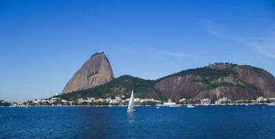
    The quiet residential district of Urca lies at the foot of Sugarloaf Mountain, where the cable car departs from Praia Vermelha, and on the seawall in front of Bar Urca, you can eat snacks with a view of Guanabara Bay.

    by Felix Gillen

    1. Home
    2. Destinations
    3. Brazil
    4. Rio de Janeiro
    5. Urca and Botafogo
    The quiet residential district of Urca lies at the foot of Sugarloaf Mountain, where the cable car departs from Praia Vermelha, and on the seawall in front of Bar Urca, you can eat snacks with a view of Guanabara Bay. In neighboring Botafogo, restaurants like the Michelin-starred Oteque and several Bib Gourmand establishments have settled.
    Brazil travel guideRound trips in BrazilPlan a trip with Urca and Botafogo

    Contents

    • Neighborhoods & highlights
    • Recommendations
    • Eat & drink
    • Getting around
    • Accommodation
    • Nearby

    Sights in Urca and Botafogo

    Discover the most important sights and attractions

    Pista Cláudio Coutinho and Morro da Urca

    Carlos Luis M C da Cruz / Wikimedia Commons / public domain

    1Pista Cláudio Coutinho and Morro da Urca

    From the Pista Cláudio Coutinho trail at Praia Vermelha, a path leads in about 40 minutes to Morro da Urca, the middle station of the Sugarloaf Cable Car. The ascent is easy to moderate; for the onward journey from Urca to Sugarloaf, you need a cable car ticket.
    Open in Google Maps

    Restaurants in Urca and Botafogo

    1

    Oteque

    Alberto Landgraf serves a single, seasonally changing tasting menu, awarded a Michelin star (2026 Guide). Rua Conde de Irajá 581, Botafogo.
    Show on Google Maps
    2

    Brota

    Creative vegetarian and vegan sharing plates in a villa in Botafogo, awarded Bib Gourmand by Guide Michelin. Rua Conde de Irajá 98.
    Show on Google Maps
    3

    Bar Urca

    Traditional bar from 1939 and city heritage: Take your snacks to the opposite seawall and eat with a view of Guanabara Bay, as Time Out recommends. Rua Cândido Gaffrée 205, Urca.
    Show on Google Maps

    Getting to

    Cable CarThe base station of the Sugarloaf Cable Car is located at Praia Vermelha in Urca. The cable car runs Monday to Friday from 8:30 AM, on weekends from 7:30 AM, with the last ascent at 7:30 PM.On FootYou can walk up Morro da Urca in about 40 minutes, starting from Pista Cláudio Coutinho.

    Accommodations in Urca and Botafogo

    Find perfect stay in Urca and Botafogo

    Booking.com* (Affiliate link)
    Search Hotels
    Agoda* (Affiliate link)
    Search Hotels
    Airbnb
    Vacation Rentals

    * Affiliate link: if you book through it, we earn a small commission. The price stays the same for you.

    Plan your trip to Urca and Botafogo

    Save places, build a route and plan your city trip, all in one place.

    1. 1
      Sunrise over alpine peaks and a sea of clouds
      1234

      Round trip

      12 days · 4 stops

      Saved

      Pick a route

      Pick a ready-made one or save places and plan your own.

      Open bookmarks
    2. 2

      Trip to Urca and Botafogo

      Live
      • 1Pista Cláudio Coutinho and Morro da Urca3 days
      Budget

      Plan your trip

      The planner sorts stops, days and budget. Plan together in real time.

      Start trip planning
    3. 3
      9:41 No signal
      Urca and Botafogo
      Available offline

      Use it on the road

      Download the guide to your phone and use it on site, even offline.

    Nearby

    Copacabana and Leme

    The Auswärtige Amt names Copacabana among the districts where thefts and muggings occur even during the day, and advises against nocturnal beach walks; the warnings are linked on their country page.Copacabana is Rio’s most famous beach district: roughly four kilometers of sand stretch from Leme rock in the northeast to Forte de Copacabana in the southwest, lined by the promenade with Roberto Burle Marx's wave pattern. Leme, at its eastern end, is a quieter, small enclave. Here, the grand Réveillon fireworks take place on New Year’s Eve.The surf is strong, and after rain, the water is often polluted: The environmental agency INEA shows the bathing water quality; green means swim, red means better stay on the beach.

    Santa Teresa and Lapa

    Santa Teresa is the artists' quarter on the hill above the city center; Time Out calls it Rio's "bohemian district." The historic Bonde goes up over the Arcos da Lapa; at the top await restaurants like Aprazível and Bar do Mineiro's feijoada. Down in Lapa are the Escadaria Selarón and samba houses like Rio Scenarium and Carioca da Gema.For Lapa, the German Foreign Office explicitly warns of K.O. drops; for your evening return, take a ride service.

    Ipanema and Leblon

    Ipanema and Leblon are the beach neighborhoods west of Copacabana; at the eastern end, the Arpoador rock juts into the sea. Behind the beach, the city's top gastronomy is clustered together, with Michelin-starred restaurants like Oro, Oseille, and Madame Olympe, and several Bib Gourmand addresses.

    Downtown and Port

    Centro is Rio's historic heart: Here stand the São Bento Monastery, the Paço Imperial, where King João VI resided from 1808, the Candelária Church, and the Belle Époque halls of Confeitaria Colombo. North of it lies the revamped port district with the Museu do Amanhã and "Pequena África" around Cais do Valongo and Pedra do Sal.The Foreign Office points out that the district is deserted and unsafe after business hours, on weekends, and public holidays; therefore, visit it on weekdays during the day.
    Rio de Janeiro

    Rio de Janeiro

    The Federal Foreign Office provides safety advice for Rio, concerning favelas, beaches at night, and K.O. drops in Lapa; this information is linked on its country page.With around 6.7 million inhabitants, Rio de Janeiro is Brazil's second-largest city, situated between granite mountains, rainforest, and Guanabara Bay. Since 2012, its urban landscape, "Carioca Landscapes between the Mountain and the Sea," has been on the UNESCO World Heritage List – the first urban cultural landscape ever. People come for the Christ the Redeemer statue on Corcovado, the Sugarloaf cable car, the beaches of Copacabana and Ipanema, and Lapa's samba nights.The city was founded on March 1, 1565; it was the capital from 1763 to 1960, and home to the Portuguese court from 1808. Its districts vary greatly: The Centro preserves monasteries and Belle Époque buildings, Santa Teresa is located on a hill above it, and the beach districts of Zona Sul stretch southwest.

    Arnaldo Silva·Pexels

    Your next steps

    Urca and Botafogo is in Brazil. Ways to carry on from here.

    • More in Brazil

      Highlights, areas, routes and the best time to travel for all of Brazil.

      Brazil travel guide
    • Round trips in Brazil

      Ready-made routes through Brazil, with stops, nights and a map.

      See the routes

    Sources & method

    • Photos: Wikimedia Commons. Each photo carries its credit.
    • Place data such as addresses and ratings comes from Google Maps.
    • The content is based on web research from public, traceable sources. How the content is made · The role of AI