Fernweh: Home
ExploreGuideDestinationsMy tripsMy trip
de|en
All Places & RegionsRound tripsNight trains in EuropeAll highlightsAbout FernwehFAQPrivacy PolicyImprint
Download on the App StoreGet it on Google Play
ExploreGuideDestinationsMy tripsMy trip
    • Neighborhoods & highlights
    • Eat & drink
    • Culture
    • Getting around
    • Accommodation
    • Plan trip
    • Round trips
    • Nearby
    Santa Barbara

    Frank Schulenburg / Wikimedia Commons / CC BY-SA 4.0, mod.

    United States

    Santa Barbara

    CityCulture

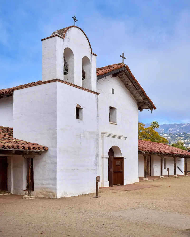
    Santa Barbara, located on the Pacific coast northwest of Los Angeles, blends Spanish heritage with beach and wine. Above the city stands the Old Mission, founded in 1786, known as the "Queen of the Missions.

    by Felix Gillen

    1. Home
    2. Destinations
    3. United States
    4. California
    5. Santa Barbara
    Santa Barbara, located on the Pacific coast northwest of Los Angeles, blends Spanish heritage with beach and wine. Above the city stands the Old Mission, founded in 1786, known as the "Queen of the Missions." In the city center, you'll find the 1929 Courthouse, built in Spanish Colonial style.State Street serves as the main axis for shopping and dining, leading down to Stearns Wharf, which dates back to 1872. Adjacent to this, the Funk Zone has become home to wine tasting rooms, breweries, and galleries.
    United States travel guideSee the round tripPlan a trip with Santa Barbara

    Contents

    • Neighborhoods & highlights
    • Eat & drink
    • Culture
    • Getting around
    • Accommodation
    • Round trips
    • Nearby

    Sights in Santa Barbara

    Discover the most important sights and attractions

    Museum

    1Old Mission Santa Barbara

    Spanish Franciscans founded the Mission in 1786; due to its beauty, it's called the “Queen of the Missions.” Self-guided tours cost $17 (Seniors $15, Youths $12), and a German audio guide is available. Open Monday to Saturday 9:30 AM to 5 PM, Sundays from 12:30 PM, with ticket sales until 4 PM.
    Open in Google Maps
    Historic Landmark

    2Santa Barbara County Courthouse

    The Spanish Colonial style courthouse was completed in 1929. From the Clock Tower, reachable by stairs or elevator, enjoy panoramic views of the city and mountains. The Mural Room features murals depicting the city's history. Free guided tours: Mon-Fri at 10:30 AM & 2 PM, weekends at 2 PM. A security check is required at the entrance.
    Open in Google Maps
    Historic Landmark

    3Stearns Wharf

    John P. Stearns built the pier in 1872; it is considered California's oldest continually used wharf. On the wooden pier, you'll find fish restaurants, a wine tasting room, and the Natural History Museum's Sea Center.
    Open in Google Maps
    Attraction

    4Funk Zone and Urban Wine Trail

    Between the beach and Highway 101, old warehouses now host restaurants, wine tasting rooms, craft breweries, distilleries, and over a dozen galleries. The Urban Wine Trail connects over 20 tasting rooms, most of them here.
    Open in Google Maps
    Garden

    5A.C. Postel Memorial Rose Garden

    Opposite the Mission, over 1,500 rose bushes bloom in this rose garden.
    Open in Google Maps

    Restaurants in Santa Barbara

    1

    Silvers Omakase

    Sushi-Omakase on Helena Avenue near the Funk Zone, awarded one star in the Michelin Guide USA 2026.
    Show on Google Maps
    2

    Loquita

    Spanish cuisine on lower State Street, awarded a Bib Gourmand by the Guide Michelin 2026.
    Show on Google Maps

    Culture and Joy

    Spanish HeritageThe 1786 Mission and the Courthouse, with its murals depicting city history, are the most famous structures. Over Memorial Day weekend, the I Madonnari Festival on Mission Plaza sees around 150 chalk artworks created.Urban WineThe Urban Wine Trail links over 20 tasting rooms, most located in the Funk Zone. The 2026 Michelin Guide lists, among others, Silvers Omakase (one star) and Loquita (Bib Gourmand).

    Traveling

    Getting ThereThe Amtrak Pacific Surfliner runs on a 351-mile route from San Luis Obispo via Santa Barbara and Los Angeles to San Diego, with sections directly along the coast.In the CityDowntown, State Street, Funk Zone, and Stearns Wharf are close together and within walking distance; the Mission is a short uphill drive.Channel IslandsThe national park is only accessible by boat: The concessionaire Island Packers operates year-round from Ventura Harbor and Channel Islands Harbor in Oxnard. There's also a visitor center in Santa Barbara. Plan early.

    Accommodations in Santa Barbara

    Find perfect stay in Santa Barbara

    Booking.com* (Affiliate link)
    Search Hotels
    Agoda* (Affiliate link)
    Search Hotels
    Airbnb
    Vacation Rentals

    * Affiliate link: if you book through it, we earn a small commission. The price stays the same for you.

    Campgrounds in Santa Barbara

    Find perfect campground in Santa Barbara

    Search via Google Maps
    Campgrounds nearby (15km)
    Camping.info
    Find Campgrounds
    Park4Night
    RV Parks & Camping

    Plan your trip to Santa Barbara

    Save places, build a route and plan your city trip, all in one place.

    1. 1
      Sunrise over alpine peaks and a sea of clouds
      1234

      Round trip

      12 days · 4 stops

      Saved

      Pick a route

      Pick a ready-made one or save places and plan your own.

      Open bookmarks
    2. 2

      Trip to Santa Barbara

      Live
      • 1Old Mission Santa Barbara3 days
      • 2Santa Barbara County Courthouse4 days
      • 3Stearns Wharf5 days
      Budget

      Plan your trip

      The planner sorts stops, days and budget. Plan together in real time.

      Start trip planning
    3. 3
      9:41 No signal
      Santa Barbara
      Available offline

      Frank Schulenburg / Wikimedia Commons / CC BY-SA 4.0, mod.

      Use it on the road

      Download the guide to your phone and use it on site, even offline.

    Round trips with Santa Barbara

    Pacific Coast Highway: From San Francisco to San Diego

    Pacific Coast Highway: From San Francisco to San Diego

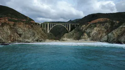
    The classic coastal route runs from San Francisco via Monterey and Carmel through Big Sur, along the Central Coast to Santa Barbara and past Los Angeles to San Diego. Drive from north to south: The ocean will be on your side, and viewpoints are reached without left turns. Highway 1 through Big Sur is often closed by landslides and wildfires, sometimes for extended periods, and traffic lights regulate single-lane passage at construction sites; therefore, check the Caltrans QuickMap (quickmap.dot.ca.gov) before your leg. After fires, hiking trails east of Highway 1 also often remain closed for long periods. In Big Sur, gas stations are rare and expensive, and cell reception is often unavailable, so fill up in Carmel and save maps offline.

    15 Days
    6 stops
    Open jaw

    Furqan Mohammed·Pexels

    Nearby

    Malibu

    Malibu

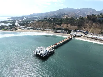
    Malibu has no real downtown. It's 21 miles of coastline strung along Pacific Coast Highway, squeezed between the Santa Monica Mountains and the ocean. It sits outside the city of Los Angeles and only incorporated in 1991. People come for the surf breaks, rocky coves and bluffs.The Franklin Fire in December 2024 and the Palisades Fire in January 2025 hit Malibu hard. The Palisades Fire destroyed nearly all the beachfront homes on the east side of town, and mudslides off the burn scar did more damage afterward. PCH reopened to everyone in May 2025, but rebuilding is far from done: expect construction zones, and some restaurants along the highway are still closed. A few trails in Topanga State Park and Will Rogers State Historic Park also remain closed.Just east of the city line, technically in Pacific Palisades, the Getty Villa recreates the Villa dei Papiri at Herculaneum and holds about 44,000 Greek, Roman and Etruscan antiquities. Farther west, Point Dume juts into the ocean, and gray whales pass by from December to mid-April. About 10 miles west of the Civic Center, trails and stairs drop down to El Matador State Beach, a small cove under the cliffs.Give Malibu a full day and bring a car. Beaches are quieter in the morning, and sunset at El Matador or Point Dume is the way to end it. On summer weekends, northbound PCH backs up by late morning, and the drive back to Santa Monica crawls in the afternoon.

    David Pickup·Pexels

    Santa Monica

    Santa Monica

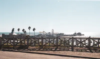
    Santa Monica is its own city, but for most visitors it's where Los Angeles meets the Pacific: a wide sandy beach, a bike path along the water and palms on the bluffs above PCH. Downtown is compact and easy to walk, which is rare in LA.The pier is the centerpiece. The Municipal Pier opened in 1909, and Charles Looff's amusement pier was added in 1916. Inside the Looff Hippodrome spins a 1922 carousel, and Pacific Park has the solar-powered Pacific Wheel. The End of the Trail sign, put up in 2009, is the photo stop for anyone finishing Route 66, though the highway officially ended at Lincoln and Olympic boulevards.A few blocks inland, the Third Street Promenade runs between Wilshire Boulevard and Broadway. It's been car-free since 1965 and is known for its street musicians and dinosaur topiaries. Downtown Santa Monica's farmers market runs Wednesdays and Saturdays. South of the pier is Original Muscle Beach, where gymnasts and bodybuilders like Jack LaLanne trained starting in 1934.The pier is at its best around sunset, when the Ferris wheel lights up. Mornings are calmer for the beach and the bike path. On sunny weekends the beach lots fill early, so the city parking structures near the Promenade are usually a better bet.

    Ed Rogers·Pexels

    Venice

    Venice

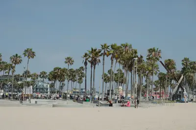
    Venice was Abbot Kinney's dream. In 1905 the developer built a seaside resort he called Venice of America, with canals, a pier and Venetian-style arcades. The town voted to join Los Angeles in 1926, and most of the canals were filled in and paved over soon after. What stuck was the counterculture streak: cheap rent drew artists and Beat poets, and The Doors got their start here in 1965.Ocean Front Walk, the 2.5-mile beachfront promenade, never really sleeps: street performers, souvenir stalls, skaters and cyclists on the beach bike path. At Muscle Beach, bodybuilders lift in front of an audience, and right next door the 2009 skatepark has bowls modeled on empty backyard pools. The graffiti-covered Venice Art Walls are a few steps away.A few blocks inland, things go quiet. In the Venice Canal Historic District, on the National Register since 1982, you can wander footbridges over six surviving canals. Abbot Kinney Boulevard, lined with boutiques, galleries and restaurants, is where Venice shops and eats.The boardwalk is liveliest on weekend afternoons. Hit the canals early in the morning or in late-afternoon light, and save Abbot Kinney for dinner. On sunny weekends the paid beach lots fill up early.

    Mariya Eskina·Pexels

    Beverly Hills and West Hollywood

    Beverly Hills and West Hollywood

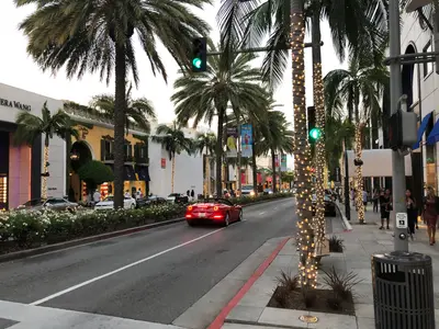
    Two separate cities surrounded by Los Angeles, with two very different personalities. Beverly Hills means mansions, palm-lined streets and designer boutiques; West Hollywood, which only incorporated in 1984, means rock history, comedy and nightlife.The famous stretch of Rodeo Drive is the three or so blocks between Wilshire Boulevard and Little Santa Monica Boulevard. The Beverly Wilshire hotel anchors the Wilshire end, and at Dayton Way, Robert Graham's sculpture Torso marks the Rodeo Drive Walk of Style. This is where Julia Roberts gets shown the door in Pretty Woman (1990). Make time for Greystone Mansion, a 1928 Tudor estate that's now a city park and has served as a set for There Will Be Blood and The Big Lebowski. For the classic photo, head to the Beverly Hills sign in Beverly Gardens Park.The Sunset Strip, 1.7 miles of Sunset Boulevard in West Hollywood, was rock and roll's main stage in the 1960s. The Doors were the house band at the Whisky a Go Go, which opened in 1964, and The Comedy Store has been going since 1972. Giant billboards still line the street.Beverly Hills is best on foot during the day. Several parking structures near Rodeo give you the first two hours free, including the one at 9510 Brighton Way. Save the Strip for later in the evening, when the shows start, and buy Comedy Store tickets online ahead of time.

    Rino Adamo·Pexels

    Hollywood

    Hollywood

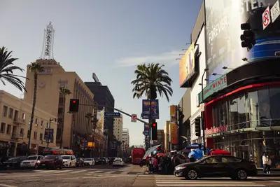
    Hollywood is less red carpet than pilgrimage. On Hollywood Boulevard, crowds shuffle over the stars of the Walk of Fame, costumed characters pose for tips, and souvenir shops crowd in between the old movie palaces. The film history is in the details: the hand- and footprints outside the TCL Chinese Theatre, or the bars where Frank Sinatra and Charles Bukowski drank.The Walk of Fame runs 1.3 miles along Hollywood Boulevard between Gower Street and La Brea Avenue, plus a stretch of Vine Street. The first permanent stars went in in 1960, and the count stood at 2,850 in June 2026. Next to the Chinese Theatre, the Ovation Hollywood complex holds the Dolby Theatre, home of the Oscars since 2002; the ceremony moves to the Peacock Theater Downtown in 2029.The Hollywood Sign has stood on Mount Lee since 1923, when it went up as an ad for the Hollywoodland subdivision. You can't get to the letters: the slope is fenced and watched by cameras, and most Beachwood Canyon streets are permit parking only. For a good look, head to the upper terraces at Ovation Hollywood or to Griffith Observatory in neighboring Griffith Park.Come in the morning, before the boulevard fills up, then come back after dark for a drink at the Frolic Room or a steak at Musso & Frank, when the neon is on and the day-trippers are gone.

    Darya Sannikova·Pexels

    Your next steps

    Santa Barbara is in United States. Ways to carry on from here.

    • More in United States

      Highlights, areas, routes and the best time to travel for all of United States.

      United States travel guide
    • Round trips with Santa Barbara

      One route passes through Santa Barbara, with stops, nights and a map.

      See the round trip

    Sources & method

    • Photos: Wikimedia Commons. Each photo carries its credit.
    • Place data such as addresses and ratings comes from Google Maps.
    • The content is based on web research from public, traceable sources. How the content is made · The role of AI