Fernweh: Home
ExploreGuideDestinationsMy tripsMy trip
de|en
All Places & RegionsRound tripsNight trains in EuropeAll highlightsAbout FernwehFAQPrivacy PolicyImprint
Download on the App StoreGet it on Google Play
ExploreGuideDestinationsMy tripsMy trip
    • Places in the region
    • Recommendations
    • Culture
    • Getting around
    • Round trips
    • Nearby
    Guna Yala (San Blas)

    Cotopaxi5897 / Wikimedia Commons / CC BY-SA 4.0, mod.

    Panama

    Guna Yala (San Blas)

    Region

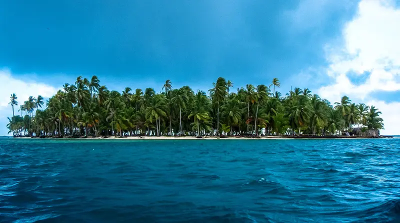
    Guna Yala is a self-governed territory of the Guna people on the Caribbean coast east of Panama City, with an archipelago of several hundred flat coral islands, only a small number of which are inhabited.

    by Felix Gillen

    1. Home
    2. Destinations
    3. Panama
    4. Guna Yala (San Blas)
    Guna Yala is a self-governed territory of the Guna people on the Caribbean coast east of Panama City, with an archipelago of several hundred flat coral islands, only a small number of which are inhabited. You come for the palm-fringed islands, the clear water and an indigenous culture that sets its own rules for its territory.After the Tule Revolution of 1925, the area was recognised as the Guna's own territory. Non-Guna may not live here, so tourist lodgings and boat trips are run by the communities. Indigenous law applies in the comarca.The region is also a focus of climate change: in 2024 the community of the flood-threatened island of Gardi Sugdub, around 300 families, moved to the new settlement of Isber Yala on the mainland. Check the current situation and the FCDO Travel Advice for Panama before you go.
    Panama travel guideSee the round tripPlan a trip with Guna Yala (San Blas)

    Contents

    • Places in the region
    • Recommendations
    • Culture
    • Getting around
    • Round trips
    • Nearby

    Sights in Guna Yala (San Blas)

    Discover the most important sights and attractions

    Natural Feature

    Cayos Limones

    The archipelago, with palm islands like Chichime, is located close to the coast and is a popular destination for many day trips. From Cartí, you can reach it by boat in 25 to 40 minutes, and a small visitor's fee is charged on the islands.
    Open in Google Maps
    Natural Feature

    Isla Iguana

    A small island near Cartí port, also reportedly suitable for longer stays. Like everywhere in Guna Yala, you pay a small visitor fee in cash.
    Open in Google Maps
    Point of Interest

    Small Dog Island

    The small island, Assudub Bipi, is known for a shipwreck close to shore where you can snorkel. From Cartí, it's a 25-minute boat trip; island fees are paid on arrival.
    Open in Google Maps

    Culture and Self-governance of the Guna

    Congreso General and SailasEvery community has a meeting house and elects a Saila (also Sahila). The highest political authority of the Comarca is the Congreso General Guna. To visit inhabited islands, you need the community's permission, and in strong winds and rough seas, the Congreso General may suspend boat traffic and tourism.MolasMolas are fabric panels made with reverse appliqué technique, which Guna women wear on their blouses. You buy them directly from the women on the islands, usually only with cash.Behavior on the IslandsOn inhabited islands, cover your shoulders and legs. On some islands, photography is prohibited; ask for permission before every photo of people, as a small fee may sometimes be requested.

    Arrival, Rules and Practicalities

    Getting there via CartíFrom Panama City, drive along the Pan-American Highway to El Llano, then take the steep road to Cartí, about 3 to 3.5 hours in total. Some climbs need a 4x4, and most visitors travel in shared 4x4 vehicles. At the roadside checkpoint you show your passport and pay the comarca fee; a small terminal fee is added at Cartí port. By boat you reach the nearby islands in 20 to 40 minutes, the Cayos Holandeses in over an hour.Fees and cashThe entrance fee for foreign visitors is around 22 US dollars, plus a few dollars of visitor fees on most islands, often included in the tour price (as of 2026). There are no ATMs, and cards are rarely accepted. Bring enough cash in small notes.Drones and boatsDrones need prior permission from the Guna authorities. Boat owners need a permit before entering the comarca. See the FCDO Travel Advice for Panama.

    Round trips through this region

    Panama in 15 Days: Canal, Guna Yala, Highlands and Caribbean

    Panama in 15 Days: Canal, Guna Yala, Highlands and Caribbean

    This round trip links the capital and the canal with the Guna Islands, the crater village El Valle, the cool highlands around Boquete, and the Caribbean islands of Bocas del Toro. Most journeys are by coach or 4x4, finally flying from Bocas del Toro back to Panama City.

    15 Days
    6 stops

    Eliécer Gómez·Pexels

    Nearby

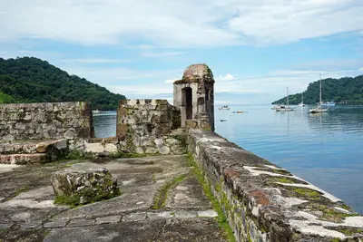
    Portobelo

    Portobelo

    Portobelo is a small town on a Caribbean bay in the province of Colón, about one and a half to two hours' drive from Panama City. On both sides of the bay lie Spanish fortresses that are part of the UNESCO World Heritage, and the town is a center of Afro-Caribbean Congo culture.The gold and silver of the Spanish crown passed through the Real Aduana, the royal custom house. The fortresses were attacked multiple times, including by Henry Morgan and later by Admiral Edward Vernon. In 2012, UNESCO placed the Portobelo-San Lorenzo World Heritage site on the List of World Heritage in Danger due to its poor state of preservation and kept it there in July 2026. Since 2025, the fortresses have been part of the Colonial Transisthmian Route.The Iglesia de San Felipe houses the Cristo Negro, to whose festival on October 21st pilgrims arrive in violet robes. At the mouth of the Río Chagres lies Fuerte San Lorenzo, the second part of the World Heritage site.

    Mariordo (Mario Roberto Durán Ortiz)·CC BY-SA 4.0

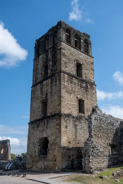
    Panamá Viejo

    Panamá Viejo

    Panamá Viejo are the ruins of the first Spanish city on the Pacific coast of the Americas, on the eastern edge of Panama City. Since 2003, they have been a UNESCO World Heritage site, and from the tower of the old cathedral, you can overlook the grounds and the bay.Pedro Arias Dávila founded the city on August 15, 1519. In 1671, the Welsh privateer Henry Morgan attacked the city, and the subsequent fire destroyed it. Afterward, it was refounded a few kilometers further west.The Patronato Panamá Viejo operates the site as an open-air museum. Inside the museum, a model shows the city as it looked before 1671.

    xiquinhosilva·CC BY 4.0

    Panama City

    Panama City

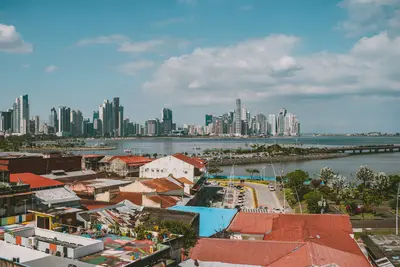
    Panama City is Panama's capital, situated at the Pacific entrance of the Panama Canal. Within a small area, you'll discover the colonial Old Town Casco Viejo, the ruins of the original city, a museum by Frank Gehry, and the Miraflores Locks.The city was founded on August 15, 1519, by Pedro Arias Dávila. After its destruction by Henry Morgan in 1671, it was rebuilt a few kilometers further west, from which today's Casco Viejo emerged. UNESCO inscribed it as a World Heritage Site in 1997 and expanded it in 2003 to include the ruins of Panamá Viejo.West of the Old Town begins the former Canal Zone around Balboa. From there, the Calzada de Amador with the Biomuseo extends into the bay. The Federal Foreign Office provides information on crime in individual districts.
    Eliécer Gómez·Pexels

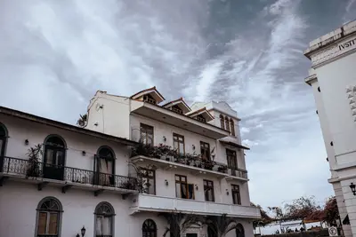
    Casco Viejo

    Casco Viejo

    Casco Viejo is the old town of Panama City, located on a peninsula on the Pacific and a UNESCO World Heritage site since 1997. Amidst churches, squares, and the old city walls, you have views of the skyline and the ships at the canal entrance.The city was rebuilt after Henry Morgan destroyed the original city of Panamá Viejo in 1671. UNESCO listed the district as “Historic District of Panamá, with the Salón Bolívar”; since 2025, it has been part of the Colonial Transisthmian Route. The Pan-American Congress, convened by Simón Bolívar, met in the Salón Bolívar.Around the Plaza de la Independencia stand the Cathedral and the Museo del Canal. At the tip of the peninsula, the Plaza de Francia commemorates the workers who died during the French canal project.

    Luis Quintero·Pexels

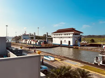
    Panama Canal and Gatun Lake

    Panama Canal and Gatun Lake

    The Panama Canal connects the Pacific and Caribbean, starting right at the edge of Panama City. At the visitor centers of Miraflores on the Pacific side and Agua Clara near Colón, you can watch ships navigate the locks.The heart of the canal route is Gatun Lake, a reservoir formed by the damming of the Río Chagres. Its largest island, Barro Colorado, has been a protected area since 1923; a research station opened there in 1924, operated by the Smithsonian since 1946. On the east bank lies Soberanía National Park with Pipeline Road, one of the country's most famous birdwatching trails.Two bridges cross the canal on the Pacific side: the Puente de las Américas from 1962 and the cable-stayed bridge Puente Centenario, inaugurated in 2004 and open to traffic since 2005.

    Kevin Alvarez·Pexels

    Your next steps

    Guna Yala (San Blas) is in Panama. Ways to carry on from here.

    • More in Panama

      Highlights, areas, routes and the best time to travel for all of Panama.

      Panama travel guide
    • Round trips with Guna Yala (San Blas)

      One route passes through Guna Yala (San Blas), with stops, nights and a map.

      See the round trip
    • Plan a trip with Guna Yala (San Blas)

      The Guide asks about season, length and who is coming, and suggests a trip with Guna Yala (San Blas).

      Plan the trip

    Sources & method

    • Photos: Wikimedia Commons. Each photo carries its credit.
    • Place data such as addresses and ratings comes from Google Maps.
    • The content is based on web research from public, traceable sources. How the content is made · The role of AI