Fernweh: Home
ExploreGuideDestinationsMy tripsMy trip
de|en
All Places & RegionsRound tripsNight trains in EuropeAll highlightsAbout FernwehFAQPrivacy PolicyImprint
Download on the App StoreGet it on Google Play
ExploreGuideDestinationsMy tripsMy trip
    • Neighborhoods & highlights
    • Eat & drink
    • Culture
    • Getting around
    • Accommodation
    • Plan trip
    • Nearby
    Sarapiquí

    Wayne77 / Wikimedia Commons / CC BY-SA 4.0, mod.

    Costa Rica

    Sarapiquí

    City

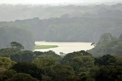
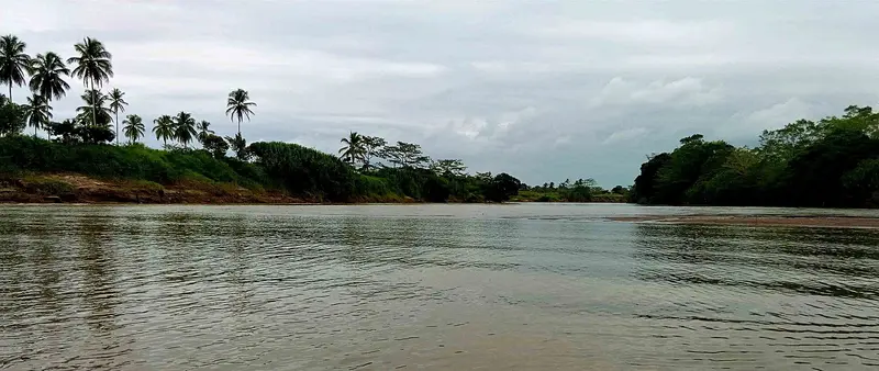
    Sarapiquí is a tropical lowland at the foot of the Cordillera Central, where the Río Sarapiquí and Río Puerto Viejo converge. You come for the rainforest, the La Selva research station, and the rafting tours on the Río Sarapiquí.

    by Felix Gillen

    1. Home
    2. Destinations
    3. Costa Rica
    4. Arenal and Monteverde
    5. Sarapiquí
    Sarapiquí is a tropical lowland at the foot of the Cordillera Central, where the Río Sarapiquí and Río Puerto Viejo converge. You come for the rainforest, the La Selva research station, and the rafting tours on the Río Sarapiquí. The area around Puerto Viejo de Sarapiquí is located approximately 80 km northeast of San José.
    Costa Rica travel guideRound trips in Costa RicaPlan a trip with Sarapiquí

    Contents

    • Neighborhoods & highlights
    • Eat & drink
    • Culture
    • Getting around
    • Accommodation
    • Nearby

    Sights in Sarapiquí

    Discover the most important sights and attractions

    Park

    1Biological Station La Selva

    The research station 3 km south of Puerto Viejo de Sarapiquí has existed since 1953 and protects around 1,600 hectares of tropical wet forest. Guided hikes of approximately 3 hours start daily at 8 AM and 1:30 PM; early bird tours and night tours are also available.
    Open in Google Maps

    Restaurants in Sarapiquí

    Culture and History

    Research in the RainforestEstación Biológica La Selva has operated as a research station since 1953. It protects approximately 1,600 hectares of primary and secondary forest and is now also accessible to visitors with guided tours.Plantations and ForestAround Puerto Viejo de Sarapiquí, agricultural plantations and forest areas alternate, and ecotourism has become an important economic sector.

    Getting There and Around

    Travel from San JoséPuerto Viejo de Sarapiquí is located approximately 80 km northeast of San José. The drive takes about 1.5 to 2 hours, following Ruta 32 through Braulio Carrillo National Park, which is occasionally closed due to landslides.On SiteThe entrance to La Selva is 3 km south of town. The Quebrada González sector of Braulio Carrillo National Park is located directly on Ruta 32.

    Accommodations in Sarapiquí

    Find perfect stay in Sarapiquí

    Booking.com* (Affiliate link)
    Search Hotels
    Agoda* (Affiliate link)
    Search Hotels
    Airbnb
    Vacation Rentals

    * Affiliate link: if you book through it, we earn a small commission. The price stays the same for you.

    Plan your trip to Sarapiquí

    Save places, build a route and plan your city trip, all in one place.

    1. 1
      Sunrise over alpine peaks and a sea of clouds
      1234

      Round trip

      12 days · 4 stops

      Saved

      Pick a route

      Pick a ready-made one or save places and plan your own.

      Open bookmarks
    2. 2

      Trip to Sarapiquí

      Live
      • 1Biological Station La Selva3 days
      Budget

      Plan your trip

      The planner sorts stops, days and budget. Plan together in real time.

      Start trip planning
    3. 3
      9:41 No signal
      Sarapiquí
      Available offline

      Wayne77 / Wikimedia Commons / CC BY-SA 4.0, mod.

      Use it on the road

      Download the guide to your phone and use it on site, even offline.

    Nearby

    Poás Volcano National Park

    Poás Volcano National Park

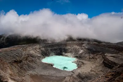
    Poás Volcano National Park is located in the Cordillera Central on the northern edge of the Valle Central, north of Alajuela and San José. You come here to gaze from a viewpoint into an active crater boasting one of the world's most acidic crater lakes.The volcano reaches 2,697 meters. In the northern crater, at approximately 2,300 meters, lies Laguna Caliente, a hot lake whose pH value is sometimes close to zero, and at the bottom of which liquid sulfur collects. A second, cold and clear lake, Laguna Botos, fills an extinct crater within the park's cloud forest.Poás is one of the country's most active volcanoes. After a major eruption in April 2017, the park remained closed for about 17 months, followed by further closures in 2025 due to increased activity. Since February 2026, the volcano has again been experiencing eruptive phases; following an eruption on August 27, 2026, SINAC has tightened visiting rules.Under the rules effective since August 28, 2026, a maximum of 1,064 people are allowed into the park per day, with only 56 people permitted at the crater viewpoint simultaneously for a maximum of 20 minutes. Only the main path to the crater and the Sendero Sombrilla de Pobre are open, and a helmet is mandatory on both. Tickets are available in advance via SINAC's online reservation system. The park is normally open from 8 AM to 4 PM, with the last entry at 2 PM.Since access rules and opening hours can change at short notice depending on activity, it's best to check the current status directly with SINAC immediately before your visit. Arrive as early as possible: the crater is often shrouded in clouds, and visibility is usually better in the morning.

    Pau Delgado·Pexels

    Irazú Volcano National Park

    Irazú Volcano National Park

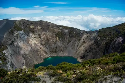
    Irazú Volcano National Park is located in the Cordillera Central above Cartago, in the east of the Central Valley. You come here to walk right up to the rim of several craters, which are among Costa Rica's most easily accessible volcanic landscapes.Irazú stands at 3,432 meters. The National Park was founded on August 9, 1955. An eruption, which began in March 1963 and lasted about two years, covered San José and large parts of the highlands with ash.At the summit are several craters, including the Main Crater, the Diego de la Haya Crater, and the small, ash-covered Playa Hermosa Crater. During the rainy season, water collects in the Main Crater and Diego de la Haya, forming colorful lagoons. On very clear days, both the Caribbean and the Pacific can be seen from the summit; such days are rare, as clouds usually hang over the peak from late morning.The park also includes the Prusia sector, a former forest reserve where reforestation has taken place and hiking trails lead through the mountain forest. Tickets are available exclusively online via the SINAC reservation system, with a fixed entry time slot. Before your visit, check there for current opening hours and whether all sectors are accessible.At over 3,000 meters, it is cold and windy, even in the tropics. Bring warm clothing and rain gear, and come early to see the craters before the clouds roll in.

    Juliana Barquero·Unsplash

    Tortuguero

    Tortuguero

    Tortuguero is a national park and a small village on Costa Rica's northern Caribbean coast, accessible only by boat or small plane. You come here for boat tours through a network of rainforest canals and lagoons, and for the sea turtles that lay their eggs on the beaches.The national park was founded in 1975 and covers approximately 312 square kilometers. On its beaches, Green Sea Turtles, Leatherback Sea Turtles, Hawksbill Sea Turtles, and Loggerhead Sea Turtles nest. The Green Sea Turtle is the most common and arrives from July to October, peaking in September and October; Leatherback Turtles nest less frequently and from March to May.The village, with around 1,200 inhabitants, is located on a narrow strip of land between the Caribbean and the canal. A car-free path connects the boat dock with the ranger station at the south end of the village. At the north end, the Sea Turtle Conservancy, which began its research in Tortuguero in 1959, operates a small visitor center with a museum.The park is best experienced via its waterways. Guided canoe or boat tours show you monkeys, sloths, birds, and caimans, which you often miss on your own; you can also rent kayaks yourself. On land, there are only a few, often muddy paths. Admission for foreign visitors costs 15 US dollars and is purchased online from SINAC; the ticket is valid for land and water trails.Turtle observation on the beach is only permitted at night with a certified guide. Cameras and white light are prohibited, and dark clothing is expected. Not far from the village rises the 119-meter-high Cerro Tortuguero, an old volcanic cone with panoramic views over canals and coastline.

    Frank Eiffert·Unsplash

    San José

    San José

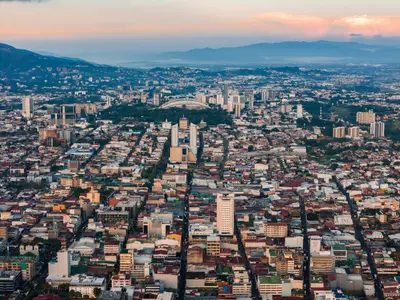
    San José is the capital of Costa Rica and the heart of the Central Valley. Almost all travelers arrive here. One to two days are sufficient to visit the museums of pre-Columbian gold and jade, the National Theater, and the market halls before continuing on to volcanoes and coasts. The city lies at an altitude of approximately 1,030 meters and has been the capital since 1823; Juan Santamaría International Airport is located a good 20 kilometers away in Alajuela.The center around the Plaza de la Cultura is compact and easily explored on foot. Here you'll find the Teatro Nacional, which opened in 1897, and below it the Museo del Oro Precolombino. A few blocks to the east are the Museo del Jade and the Museo Nacional, located in the former Bellavista army barracks. West of the Cathedral, the Mercado Central has occupied an entire block on Avenida Central since 1880, featuring over 200 stalls and simple sodas in narrow passageways.Barrio Amón, north of the center, emerged in the late 19th century as a residential quarter for the coffee oligarchy. Among low wooden houses with verandas and wrought-iron railings stand buildings like the 1930 Mudéjar-style Castillo del Moro or the prefabricated metal building from 1890, which has housed the Alianza Francesa since 1965. Many of the restored villas now accommodate small hotels, cafés, and galleries. Some streets are considered sparsely populated in the evenings, so you're better off taking a taxi at night there.Barrio Escalante in the east is the city's restaurant district. Around Calle 33, eateries have set up shop in old residential buildings: vegan cafés, specialty coffee, craft beer pubs, and cuisines ranging from Mediterranean to Mexican. This area is liveliest in the evenings, and accordingly, most of the city's bars are located in this neighborhood.

    César Badilla Miranda·Unsplash

    Central Valley

    Central Valley

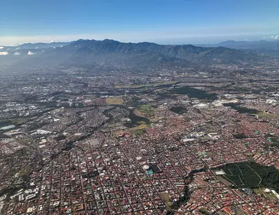
    The Valle Central is the highlands in the heart of Costa Rica, home to the capital San José and the cities of Alajuela, Heredia, and Cartago. Almost every trip begins here, as the international airport is located in Alajuela, and from here you can quickly reach active volcanoes, museums, and colonial churches.The valley lies at an altitude of about 800 to 1,500 meters. To the north, it is bounded by the Cordillera Central with the volcanoes Poás, Barva, Irazú, and Turrialba, and to the south by the Cordillera de Talamanca. Temperatures are mostly between 18 and 30 degrees, significantly milder than on the coasts.Almost three-quarters of the population lives in the Valle Central; consequently, roads, traffic, and services are dense. For travelers, this means: short distances to the Poás and Irazú Volcano Parks, a good day for the museums in San José, and a side trip to Cartago for the Basilica.

    Mariordo (Mario Roberto Durán Ortiz)·CC BY-SA 4.0

    Your next steps

    Sarapiquí is in Costa Rica. Ways to carry on from here.

    • More in Costa Rica

      Highlights, areas, routes and the best time to travel for all of Costa Rica.

      Costa Rica travel guide
    • Round trips in Costa Rica

      Ready-made routes through Costa Rica, with stops, nights and a map.

      See the routes

    Sources & method

    • Photos: Wikimedia Commons. Each photo carries its credit.
    • Place data such as addresses and ratings comes from Google Maps.
    • The content is based on web research from public, traceable sources. How the content is made · The role of AI