Fernweh: Home
    ExploreTravel GuidesPlan a tripMy tripLast visited
    de|en
    All Places & RegionsAll highlightsAbout FernwehFAQPrivacy PolicyImprint
    ExploreTravel GuidesPlan a tripMy tripLast visited
    • Neighborhoods & highlights
    • Eat & drink
    • Food culture
    • Culture
    • Getting around
    • Accommodation
    • Plan trip
    • Nearby
    Khao Lak

    Thailand

    Khao Lak

    City

    Khao Lak in Phang Nga province is not a single town, but a string of beaches and settlements north of Phuket.

    by Felix Gillen

    1. Home
    2. Destinations
    3. Thailand
    4. Andamanensee-Küste
    5. Khao Lak
    Khao Lak in Phang Nga province is not a single town, but a string of beaches and settlements north of Phuket. The beaches Nang Thong, Bang Niang, and Khuk Khak stretch for miles and are less developed than the famous beaches on Phuket; many families and divers come here.Khao Lak is a starting point for diving trips to the Similan Islands, with boats departing from the nearby Thap Lamu pier. On the land side, it borders the Khao Lak-Lam Ru National Park, featuring coastal forest and viewpoints.No other Thai coast was as severely hit by the 2004 tsunami as this one. Among other things, Police Boat 813 serves as a reminder of this, which the wave carried approximately two kilometers inland and which now stands in a memorial park. The season runs approximately from November to April; during the rainy season, many businesses close, and boat tours to the islands are suspended.

    Sights in Khao Lak

    Discover the most important sights and attractions

    1Police Boat 813

    The patrol boat was carried approximately two kilometers inland during the 2004 Tsunami and has since remained in Bang Niang at the spot where it came to rest. The memorial park surrounding the boat is shaped like a wave, with its height matching that of the tidal wave; stone tablets list the names of the victims, and information boards explain the events of December 26, 2004.
    Open in Google Maps

    2Khao-Lak-Lam-Ru National Park

    The National Park begins directly south of the town, where the hills reach to the coast. From the park center on the main road, a short path leads to a viewpoint over the Andaman Sea and longer trails through rainforest to small streams. Another access point is located at Chong Fa. Admission is charged at the entrance.
    Open in Google Maps

    3Ton Chong Fa Waterfall

    Open in Google Maps

    4

    The old tin town is about 30 kilometers north of Khao Lak, roughly half an hour by car. The old town features Sino-Portuguese shophouses with colourful facades and wooden shutters, some restored, some dilapidated. On Sundays from late afternoon, the old town becomes a market with food stalls, snacks, and handicrafts, mostly frequented by Thais. On other days, it is very quiet.
    Open in Google Maps

    5

    The fishing village Ban Nam Khem, 26 km north of Khao Lak, lost a quarter of its residents to the 2004 tsunami. At the beach memorial park, a long, curved, wave-shaped concrete wall commemorates the flood; plaques list Thai and foreign victims. A golden Buddha statue overlooking the sea survived the tsunami. Daily 8 AM – 8 PM, free admission.
    Open in Google Maps

    Essen & Trinken

    1

    The Kati Restaurant Khao Lak

    A Thai restaurant in Khao Lak, named for the coconut milk central to Southern Thai curries. Offering the usual range of dishes, plus fish and seafood. Its open dining room primarily attracts guests from surrounding resorts. If you prefer spicy, specify – the kitchen caters to European palates.
    Show on Google Maps
    2

    Param Para Restaurant Khao Lak

    An Indian restaurant in Khao Lak, with curries, flatbreads, and several vegetarian dishes on the menu. The decor is understated, the ambiance peaceful. In a destination where almost every menu is Thai, a practical diversion after a few days.
    Show on Google Maps
    3

    Qcumber

    A restaurant in Khao Lak that features both Thai and Western cuisine. The atmosphere is relaxed and geared towards resort guests, serving lunch and dinner. An uncomplicated choice when the group can't agree on a cuisine.
    Show on Google Maps
    4

    Unbekannter Ort

    A Khao Lak eatery focusing on grilled fish and seafood. Choose from the display; payment is by weight – ask for the per-kilo price before selecting. Preparation is intentionally simple, accompanied by Thai side dishes. The atmosphere is casual, perfect after a day at the beach.
    Show on Google Maps

    Food and Beverages

    Dining in Khao Lak exists between two poles: the food stalls at Bang Niang Market and on the main road, offering affordable Southern Thai cuisine, and the restaurants along the beach access roads, which cater to international guests. Fish comes from Tab Lamu and Ban Nam Khem, the vegetables from the hinterland. Southern Thai spiciness is often toned down in tourist kitchens — those who want it must explicitly order it.

    Grilled Fish from Tab Lamu

    Snapper, Mackerel or Barracuda, salt-crusted or herb-stuffed, charcoal-grilled. Served whole and charged by weight, with rice and a spicy dipping sauce.

    Kaeng Tai Pla

    The most intense curry of Southern Thailand, based on fermented fish offal, with bamboo shoots and eggplant. Very spicy and salty, found in local kitchens and at the market.

    Hoi Thod

    Batter-fried clams, egg, and bean sprouts, crisp outside, soft inside. A typical Andaman Coast dish and an evening market stall classic.

    Moo Ping and Gai Yang

    Marinated pork and chicken skewers grilled, arranged in rows over the embers at Bang Niang Market. Eaten with sticky rice in a bag.

    Khanom Jeen

    Fermented rice noodles served with various curries, plus a basket of raw vegetables and herbs to choose from. A breakfast and lunch meal.

    Regional tropical fruits

    Phang Nga grows mangosteen, rambutan, langsat, and durian. The season is in the Thai summer, partly overlapping with the rainy season; at the market, it's sold cut and in portions.

    Culture and History

    Tin and TourismThe region thrived on tin for a long time. Takua Pa, about 30 kilometers north, was a tin mining center in the 19th and early 20th centuries, attracting Chinese immigrants; their Sino-Portuguese shophouses still stand today. Later, rubber, oil palm, fishing, and tourism developed.The 2004 TsunamiOn December 26, 2004, the tsunami hit Khao Lak more severely than any other part of Thailand's coast. Memorial sites, like the park around Police Boat 813 in Bang Niang, shaped like a wave with victims' names, keep the memory alive. Discretion is advised when visiting, as many locals lost relatives.In temples, mosques, and villages, covered clothing is required; swimwear remains at the beach.

    Getting There and On-Site

    Getting ThereThe nearest airport is Phuket, approximately 80 kilometers to the south. By taxi or pre-booked transfer, the journey takes about 1 to 1.5 hours. With the public bus, it takes 2 to 2.5 hours; it stops on Highway 4.Getting AroundEverything is spread out along Highway 4, and distances are longer than the map suggests.Scooter: the most practical option for getting between beaches, the market, and waterfalls. The highway is well-maintained but busy.Songthaew: runs along the road during the day and stops on request.Taxi and Hotel Shuttle: for journeys after dark or with diving equipment.Dive boats to the Similan Islands depart from Thap Lamu Pier, south of the town, usually early in the morning; operators typically pick up guests from their accommodation.

    Accommodations in Khao Lak

    Find perfect stay in Khao Lak

    Booking.com* (Affiliate link)
    Search Hotels
    Agoda* (Affiliate link)
    Search Hotels
    Airbnb
    Vacation Rentals

    * Affiliate link: if you book through it, we earn a small commission. The price stays the same for you.

    Plan your trip to Khao Lak

    Save places, build a route and plan your city trip, all in one place.

    1. 1
      Sunrise over alpine peaks and a sea of clouds
      1234

      Round trip

      12 days · 4 stops

      Saved

      Pick a route

      Pick a ready-made one or save places and plan your own.

      Open bookmarks
    2. 2

      Trip to Khao Lak

      Live
      • 1Police Boat 8133 days
      • 2Khao-Lak-Lam-Ru National Park4 days
      • 3Ton Chong Fa Waterfall5 days
      Budget

      Plan your trip

      The planner sorts stops, days and budget. Plan together in real time.

      Start trip planning
    3. 3
      9:41 No signal
      Khao Lak
      Available offline

      Use it on the road

      Download the guide to your phone and use it on site, even offline.

    Nearby

    Khao Sok Village

    Khao Sok Village

    Around the Visitor Center of Khao Sok National Park, the region's infrastructure has congregated in Khlong Sok village: guesthouses and lodges along the road and river, tour offices, restaurants, and a small market. The main road between Surat Thani and Takua Pa passes directly by, making the location easily accessible from both coasts.From the park entrance, the main hiking trail begins, following the valley with branches leading to several waterfalls. Night hikes are only possible with a guide and are organized locally. During the dry season, especially from January to March, the Rafflesia kerrii blooms in the region, with flowers reaching 50 to 90 centimeters in diameter.The village also serves as a starting point for trips to Cheow Lan Lake, available as day or overnight tours.Several elephant camps operate in the vicinity, each with a very different approach. Those who value animal welfare should check in advance what a camp truly offers.
    Khao Sok River

    Khao Sok River

    The Sok River runs along the western edge of Khao Sok National Park and flows past Khlong Sok village, home to most of the region's accommodations. Many lodges are situated directly on its banks, making the river at once a transport route, a swimming area, and a scenic vista.On the water, activities include tubing, canoe trips, and rides on bamboo rafts. The current is mostly calm, making the tours more about the scenery than strenuous sport: Above the river, the park's limestone cliffs ascend, and with a little patience, hornbills, kingfishers, and monkeys can be spotted along the banks.The water level fluctuates significantly. After rain, the river carries much more water, while during the dry season, it can become very shallow in certain areas; operators adjust routes accordingly. Early mornings and dusk are the best times for wildlife observation, and the heat is more tolerable than at midday.
    Phang-Nga Bay

    Phang-Nga Bay

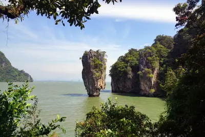
    Phang Nga Bay, north of Phuket, has been protected as Ao Phang Nga National Park since 1981, covering around 400 square kilometers. Here, steep limestone islands rise from the shallow sea, and along the coast grows Thailand's largest contiguous original mangrove forest.The bay is primarily known for Khao Phing Kan, the James Bond Island, where scenes from the 1974 film The Man with the Golden Gun were filmed. In front of it stands the narrow rock pinnacle Ko Tapu. Another destination is the stilt village of Ko Panyi.Most visitors arrive by boat tour from Phuket, Krabi, or the mainland near Phang Nga. On weekends and during high season, the popular spots can get very crowded; early departures are quieter.
    Khao Sok Region (Surat Thani Inland)

    Khao Sok Region (Surat Thani Inland)

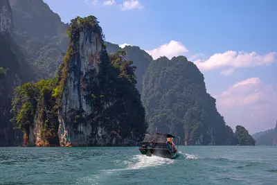
    The Khao Sok Region is located in southern Thailand, inland in the provinces of Surat Thani and Phang Nga, approximately halfway between the Gulf and Andaman coasts. This makes it an obvious stopover between the coasts.Characterized by steep limestone mountains rising above evergreen rainforest and *Cheow Lan Lake*: A dam flooded a valley system, leaving the mountaintops standing as rocky towers in the water. The Khao Sok National Park protects a large contiguous rainforest, home to hornbills, gibbons, and wild elephants, among other species.Infrastructure is concentrated around Khlong Sok village at the park entrance and the floating raft houses on the lake. Guided jungle treks, canoe tours, and cave visits are common activities.The driest period is from January to March, with most rainfall occurring from May to October. Following heavy rain, streams and caves carry a lot of water, and some paths may be closed.
    Similan Islands

    Similan Islands

    The Similan Islands are located about 70 kilometers off the coast of Phang Nga and form the Mu Ko Similan National Park. The name comes from Yawi, a Malay dialect, and means "nine". Today, the park comprises eleven islands, numbered from north to south. The largest is Koh Similan, Island 8.Above water, rounded granite boulders and white sandy coves shape the landscape. On the east sides are shallow coral slopes, on the west sides rock formations with passages like Elephant Head Rock. Manta rays and whale sharks are rare, most likely between February and April.The park is closed from May 16th to October 15th. Overnight stays on the islands are no longer possible since October 2019; you can visit as a day guest or on a liveaboard dive safari. The number of daily visitors is limited.

    Sources & method

    • Photos: Unsplash. Each photo carries its credit.
    • The content is based on web research from public, traceable sources. How the content is made · The role of AI