Fernweh: Home
    ExploreTravel GuidesPlan a tripMy tripLast visited
    de|en
    All Places & RegionsAll highlightsAbout FernwehFAQPrivacy PolicyImprint
    ExploreTravel GuidesPlan a tripMy tripLast visited
    Similan Islands

    Thailand

    Similan Islands

    National Park

    The Similan Islands are located about 70 kilometers off the coast of Phang Nga and form the Mu Ko Similan National Park. The name comes from Yawi, a Malay dialect, and means "nine".

    by Felix Gillen

    1. Home
    2. Destinations
    3. Thailand
    4. Andamanensee-Küste
    5. Similan Islands
    The Similan Islands are located about 70 kilometers off the coast of Phang Nga and form the Mu Ko Similan National Park. The name comes from Yawi, a Malay dialect, and means "nine". Today, the park comprises eleven islands, numbered from north to south. The largest is Koh Similan, Island 8.Above water, rounded granite boulders and white sandy coves shape the landscape. On the east sides are shallow coral slopes, on the west sides rock formations with passages like Elephant Head Rock. Manta rays and whale sharks are rare, most likely between February and April.The park is closed from May 16th to October 15th. Overnight stays on the islands are no longer possible since October 2019; you can visit as a day guest or on a liveaboard dive safari. The number of daily visitors is limited.

    Sehenswürdigkeiten

    Discover the most important sights and attractions

    1Turtle Rock

    Dive and snorkel site off the northwest side of Koh Similan (Island 8), west of Donald Duck Bay. It is named after a rock that resembles a turtle above water, but sea turtles are also frequently spotted here. Between 10 and 15 meters lie granite boulders with swim-throughs and brain, table, and staghorn corals. This site is suitable for all diving levels.
    Open in Google Maps

    2Breakfast Bend

    Attraction in Similan Islands.
    Open in Google Maps

    3Sailboat rock

    Attraction in MJ8X+W74.
    Open in Google Maps

    4Ao Kuerk

    A bay on the west side of the archipelago, with rounded granite blocks reaching into the surf. The beach is short and rocky, with water deep enough for snorkeling along the blocks. The islands' west sides face the open sea, resulting in more frequent swells here than in the eastern anchorages. Certain beach sections in the park are temporarily closed when turtles nest there.
    Open in Google Maps

    5Elephant Head Rock (Hin Pousar)

    Granite pinnacles southwest of Koh Similan (Island 8), which above water resemble an elephant's head. Below the surface, the rock continues in a labyrinth of blocks, channels, and passages. This site is one of the most famous dive spots in the Andaman Sea, but due to swell and sometimes strong currents, it is only suitable for experienced divers, not for snorkeling.
    Open in Google Maps

    Restaurants in Similan Islands

    Park Management Restaurant on Koh Miang

    The National Park's only restaurant sits by the park headquarters on Koh Miang, island four. Serving simple Thai dishes and drinks, it's open approx. 8 AM-2 PM. Day visitors mostly eat on their boats. Cash only; closed outside park season.
    Show on Google Maps

    Provisions

    The Similans are uninhabited: there are no villages, no shops, and no dining options apart from the park administration's canteen on Koh Miang. Those booking a day trip will be catered for by the boat — typically a lunch on board or on the beach, along with water and fruit. On liveaboard dive trips, the galley prepares the meals. You should specify any special dietary requirements when booking, as nothing can be ordered extra once underway. Drinking water is provided on board; bringing your own bottle is advisable, because single-use plastic is not permitted in the park.

    Catering on board day boats

    On speedboat tours from Thap Lamu, a simple Thai lunch is usually included, along with fruit and water. It is served on board or on the beach.

    Park Management's Restaurant on Koh Miang

    Simple Thai dishes and drinks, open roughly from 8 AM to 2 PM. Cash only, closed off-season.

    Cuisine on Diving Safaris

    On multi-day trips, meals are cooked on board, with multiple servings daily, timed for the dives.

    What you should bring with you

    A reusable water bottle, as single-use plastic is forbidden in the park. Also sun protection and your own snacks if needed.

    Arrival and Season

    There is no airport, no ferry service, and no accommodation on the islands. All visits are via an organized boat from the mainland.Season: The park is open from October 15th to May 15th and may close earlier due to bad weather. The calmest conditions are usually between December and April.Speedboat Day Trips: Depart early morning from Thap Lamu Pier, south of Khao Lak. Travel time is approximately 90 minutes. Operators offer pick-up in Khao Lak; from Phuket, transport to the pier is additional.Dive Safaris: Multi-day trips departing from Thap Lamu, staying overnight on board, often visiting Koh Bon, Koh Tachai, and Richelieu Rock in addition to the Similans.Entry fee is 500 Baht for adults and 250 Baht for children, usually paid via the tour operator. Daily visitor numbers are limited, so tours are often fully booked during peak season. Single-use plastic is prohibited in the park, as is feeding fish and touching coral.For current safety and health advice, including regarding boat trips, please refer to the Federal Foreign Office.

    Accommodations in Similan Islands

    Find perfect stay in Similan Islands

    Booking.com* (Affiliate link)
    Search Hotels
    Agoda* (Affiliate link)
    Search Hotels
    Airbnb
    Vacation Rentals

    * Affiliate link: if you book through it, we earn a small commission. The price stays the same for you.

    Nearby

    Khao Lak

    Khao Lak

    Khao Lak in Phang Nga province is not a single town, but a string of beaches and settlements north of Phuket. The beaches Nang Thong, Bang Niang, and Khuk Khak stretch for miles and are less developed than the famous beaches on Phuket; many families and divers come here.Khao Lak is a starting point for diving trips to the Similan Islands, with boats departing from the nearby Thap Lamu pier. On the land side, it borders the Khao Lak-Lam Ru National Park, featuring coastal forest and viewpoints.No other Thai coast was as severely hit by the 2004 tsunami as this one. Among other things, Police Boat 813 serves as a reminder of this, which the wave carried approximately two kilometers inland and which now stands in a memorial park. The season runs approximately from November to April; during the rainy season, many businesses close, and boat tours to the islands are suspended.
    Khao Sok Village

    Khao Sok Village

    Around the Visitor Center of Khao Sok National Park, the region's infrastructure has congregated in Khlong Sok village: guesthouses and lodges along the road and river, tour offices, restaurants, and a small market. The main road between Surat Thani and Takua Pa passes directly by, making the location easily accessible from both coasts.From the park entrance, the main hiking trail begins, following the valley with branches leading to several waterfalls. Night hikes are only possible with a guide and are organized locally. During the dry season, especially from January to March, the Rafflesia kerrii blooms in the region, with flowers reaching 50 to 90 centimeters in diameter.The village also serves as a starting point for trips to Cheow Lan Lake, available as day or overnight tours.Several elephant camps operate in the vicinity, each with a very different approach. Those who value animal welfare should check in advance what a camp truly offers.
    Khao Sok River

    Khao Sok River

    The Sok River runs along the western edge of Khao Sok National Park and flows past Khlong Sok village, home to most of the region's accommodations. Many lodges are situated directly on its banks, making the river at once a transport route, a swimming area, and a scenic vista.On the water, activities include tubing, canoe trips, and rides on bamboo rafts. The current is mostly calm, making the tours more about the scenery than strenuous sport: Above the river, the park's limestone cliffs ascend, and with a little patience, hornbills, kingfishers, and monkeys can be spotted along the banks.The water level fluctuates significantly. After rain, the river carries much more water, while during the dry season, it can become very shallow in certain areas; operators adjust routes accordingly. Early mornings and dusk are the best times for wildlife observation, and the heat is more tolerable than at midday.
    Phang-Nga Bay

    Phang-Nga Bay

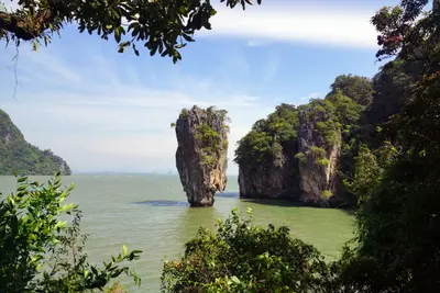
    Phang Nga Bay, north of Phuket, has been protected as Ao Phang Nga National Park since 1981, covering around 400 square kilometers. Here, steep limestone islands rise from the shallow sea, and along the coast grows Thailand's largest contiguous original mangrove forest.The bay is primarily known for Khao Phing Kan, the James Bond Island, where scenes from the 1974 film The Man with the Golden Gun were filmed. In front of it stands the narrow rock pinnacle Ko Tapu. Another destination is the stilt village of Ko Panyi.Most visitors arrive by boat tour from Phuket, Krabi, or the mainland near Phang Nga. On weekends and during high season, the popular spots can get very crowded; early departures are quieter.
    Khao Sok Region (Surat Thani Inland)

    Khao Sok Region (Surat Thani Inland)

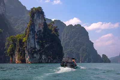
    The Khao Sok Region is located in southern Thailand, inland in the provinces of Surat Thani and Phang Nga, approximately halfway between the Gulf and Andaman coasts. This makes it an obvious stopover between the coasts.Characterized by steep limestone mountains rising above evergreen rainforest and *Cheow Lan Lake*: A dam flooded a valley system, leaving the mountaintops standing as rocky towers in the water. The Khao Sok National Park protects a large contiguous rainforest, home to hornbills, gibbons, and wild elephants, among other species.Infrastructure is concentrated around Khlong Sok village at the park entrance and the floating raft houses on the lake. Guided jungle treks, canoe tours, and cave visits are common activities.The driest period is from January to March, with most rainfall occurring from May to October. Following heavy rain, streams and caves carry a lot of water, and some paths may be closed.

    Sources & method

    • Photos: Unsplash. Each photo carries its credit.
    • The content is based on web research from public, traceable sources. How the content is made · The role of AI