Fernweh: Home
    ExploreTravel GuidesPlan a tripMy tripLast visited
    de|en
    All Places & RegionsAll highlightsAbout FernwehFAQPrivacy PolicyImprint
    ExploreTravel GuidesPlan a tripMy tripLast visited
    • Neighborhoods & highlights
    • Eat & drink
    • Food culture
    • Culture
    • Getting around
    • Accommodation
    • Plan trip
    • Nearby
    Koh Chang

    Thailand

    Koh Chang

    City

    Koh Chang is situated in the east of the Gulf of Thailand, off Trat province and close to the Cambodian border. Covering approximately 210 square kilometers, it is one of the country's largest islands.

    by Felix Gillen

    1. Home
    2. Destinations
    3. Thailand
    4. East Coast (Chonburi to Trat)
    5. Koh Chang
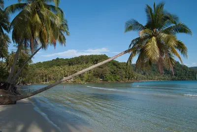
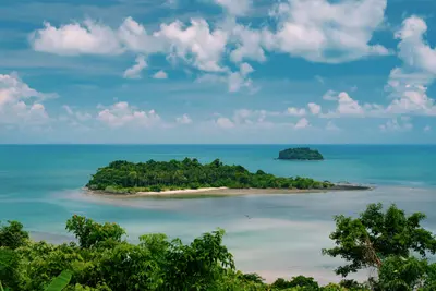
    Koh Chang is situated in the east of the Gulf of Thailand, off Trat province and close to the Cambodian border. Covering approximately 210 square kilometers, it is one of the country's largest islands. Its interior comprises forested mountains, part of Mu Ko Chang National Park. The coastal strip, traversed by a road with steep ramps, is the primary inhabited area.Along the west coast, the beaches line up: Hat Sai Khao (White Sand Beach) in the north is the most developed, followed further south by Klong Prao and Kai Bae, then the quieter Lonely Beach. At the southern end, the fishing village of Bang Bao sits on stilts over the water, with its pier being the starting point for diving and island boats.In the island's interior, short trails lead to waterfalls like Khlong Phlu, and longer rainforest tours are available with guides. Off the southern tip lie additional national park islands, accessible by boat.The island is reached by car ferry from Ao Thammachat Pier near Laem Ngop; from Bangkok, travel to Trat is by bus or flight. The dry season, from November to April, is the most reliable time to visit. During the rainy season, heavy rainfall occurs, and some businesses close.

    Sights in Koh Chang

    Discover the most important sights and attractions

    1Silent Beach

    A short stretch of beach on Koh Chang's west coast, framed by vegetation and without the development of the larger bays. Infrastructure is limited to a few establishments; sellers are rare. Those staying here should bring water and provisions. Mornings are the least busy.

    Open in Google Maps

    2Kai Bae Beach

    A long beach on Koh Chang's west coast, backed by resorts, shops, and food stalls of an established settlement. The water is shallow and safe for swimmers; at low tide, you can wade to the offshore islets. The sun sets directly over the bay, making the beach lively in early evening. It's quieter in the morning when the fishing boats return.
    Open in Google Maps

    3Bang Bao

    Fishing village in the island's southwest, built on stilts over the water. Along the long wooden pier, you'll find shops, restaurants, and dive centers. From the end of the pier, boat tours depart for the smaller islands to the south.
    Open in Google Maps

    4Klong Plu Waterfall

    One of the island's most visited waterfalls, inland from Khlong Prao in the National Park. From the entrance, an approximate 20-minute forest walk leads to a large pool at the base of the falls for bathing. National Park entrance fee applies; access may be closed after heavy rain.
    Open in Google Maps

    5White Sand Beach (Haad Sai Khao)

    The most densely developed beach on the Northwest coast, with the widest selection of accommodations, restaurants, and shops. The section is long and the sand is light, but it is also the busiest here. In the rainy season, some businesses close.
    Open in Google Maps

    6Lonely Beach (Haad Tha Nam)

    A beach section in the southwest, which long carried the island's backpacker reputation and today attracts a more mixed crowd. The current is strong in some places, and the entry drops off steeply in sections.
    Open in Google Maps

    Essen & Trinken

    1

    VOSA ROTi pancake 1

    A Roti stand on Koh Chang. The dough is hand-beaten thin, cooked on a griddle, and filled with banana, egg, or sweets. Watch it being made right at the counter, eaten on the go. A small snack for in-between, not a restaurant meal.
    Show on Google Maps
    2

    Puktip restaurant

    A Thai restaurant on Koh Chang with fish and seafood on the menu, typical for a coastal location. Simple decor and a family-run atmosphere. A casual spot for dinner, no pretensions to fine dining.
    Show on Google Maps
    3

    The Godmother KohChang

    A Koh Chang restaurant with a Thai menu, emphasizing fish and seafood. The atmosphere is relaxed and unpretentious, the clientele mainly travelers from nearby accommodations. In the evening, the place fills up early.
    Show on Google Maps
    4

    Family Coffee

    A café and restaurant on Koh Chang, offering Thai dishes and Western breakfast options side-by-side, plus coffee and fruit shakes. The decor is simple, and the establishment is family-run. A good spot to start your day before heading to the beach or the National Park.
    Show on Google Maps
    5

    Tachad and yay eing

    A small Thai eatery on Koh Chang, catering to local guests rather than tour groups. The menu sticks to local cuisine, with fish and seafood playing a key role. The decor is simple, and the pace relaxed.
    Show on Google Maps

    Dining and Drinks

    The East Coast provinces' cuisine strongly utilizes seafood and local fruits, such as Durian, Rambutan, and Mangosteen from Trat Province plantations. At the Bang Bao pier and in Salak Phet, fish is sold and prepared directly at the dock. Along the West Coast beaches, you'll also discover many international menus.

    Grilled seafood at the pier

    In Bang Bao and Salak Phet, ordered by weight and freshly prepared over charcoal. Clarify price per kilogram beforehand.

    Gaeng Som Pla

    Sour-spicy fish curry, soured with tamarind. Served with rice.

    Fruit from Trat Province

    Trat is a fruit-growing region. Its durian, rambutan, and mangosteen arrive fresh on markets during harvest season.

    Khao Tom Pla

    Rice soup with fish, ginger, and celery, a common breakfast.

    Kai Bae & Khlong Prao

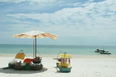
    In the town centers, you'll find street food stalls and market stalls away from the beach restaurants, where prices are lower.

    Culture and Life

    Prior to tourism, Koh Chang subsisted on fishing, rubber cultivation, and fruit farming. Stilt settlements of fishing families dot Bang Bao in the south and Salak Phet in the southeast, though the pier in Bang Bao is now predominantly lined with shops and restaurants. The island's interior is characterized by rubber groves and fruit orchards.On January 17, 1941, a naval battle occurred off the island between a French squadron and the Royal Thai Navy, commemorated by a memorial in Laem Ngop on the mainland. Since 1982, Koh Chang and its surrounding islands have belonged to the Mu Ko Chang National Park, which is why the rainforest in the island's interior has largely remained intact.In daily life, the national park status means an entrance fee is levied for waterfalls and hiking trails, and paths can be closed after heavy rainfall. At the island's temples, the usual rules apply: covered shoulders and knees, shoes off before entering.

    Arrival and getting around

    To get there, you travel via the provincial capital Trat, which can be reached by bus or flight from Bangkok. From Trat, you continue to the Ao Thammachat ferry pier near Laem Ngop. The car ferry takes approximately 30 to 40 minutes to Ao Sapparot in the island's northwest and departs several times an hour during the day, but not at night. Journeys from the Southern Gulf (Koh Samui, Koh Tao) typically go via Bangkok and are accordingly long.On the island, Songthaews operate along the west coast road. Between Kai Bae and Lonely Beach, the road is very steep and winding, and after rain, the surface is slippery. The east coast is only partially served by shared taxis; a rental vehicle is recommended here. You can find current safety and traffic information from the Auswärtiges Amt.The rainy season, from approximately May to October, significantly transforms the island. Some accommodations, restaurants, and dive centers close during these months, and boat tours are cancelled if the sea is rough. The more reliable time to visit is between November and April. If you're coming in the off-season, you should check beforehand whether your chosen accommodation is open.

    Accommodations in Koh Chang

    Find perfect stay in Koh Chang

    Booking.com* (Affiliate link)
    Search Hotels
    Agoda* (Affiliate link)
    Search Hotels
    Airbnb
    Vacation Rentals

    * Affiliate link: if you book through it, we earn a small commission. The price stays the same for you.

    Plan your trip to Koh Chang

    Save places, build a route and plan your city trip, all in one place.

    1. 1
      Sunrise over alpine peaks and a sea of clouds
      1234

      Round trip

      12 days · 4 stops

      Saved

      Pick a route

      Pick a ready-made one or save places and plan your own.

      Open bookmarks
    2. 2

      Trip to Koh Chang

      Live
      • 1Silent Beach3 days
      • 2Kai Bae Beach4 days
      • 3Bang Bao5 days
      Budget

      Plan your trip

      The planner sorts stops, days and budget. Plan together in real time.

      Start trip planning
    3. 3
      9:41 No signal
      Koh Chang
      Available offline

      Use it on the road

      Download the guide to your phone and use it on site, even offline.

    Nearby

    Koh Kood

    Koh Kood

    Koh Kood (also known as Koh Kut) lies in the Gulf of Thailand off Trat province, near the Cambodian border. Approximately 25 kilometers long, it is the second largest island in the province after Koh Chang, and forms its own district with just a few thousand residents.The island is hilly and forested; coconut plantations and fishing villages are found along its coasts. The beaches line the west coast, including Khlong Chao at the mouth of the river of the same name. Inland lies the Khlong Chao Waterfall with a deep pool for swimming.Koh Kood is less developed than Koh Chang, and there is hardly any nightlife. The main season runs from late year to early summer, when the sea is calmer.
    East Coast (Chonburi to Trat)

    East Coast (Chonburi to Trat)

    The East Coast stretches from Chonburi southeast of Bangkok, via Rayong and Chanthaburi, to Trat on the border with Cambodia. It is the coast conveniently reachable by land from Bangkok, without a domestic flight or an overnight train.The character changes quickly: Pattaya in the north is a large, loud beach resort with its own history, while Koh Chang and the islands off Trat are much quieter and largely national park. While sharing the sea with South Gulf islands like Koh Samui and Koh Tao, the region differs in access and travel season: getting here involves Bangkok, and the rainy season is different.
    Koh Samet

    Koh Samet

    Koh Samet is located off the coast of Rayong province, approximately 220 kilometers southeast of Bangkok, making it one of the capital's most quickly accessible beach islands. The island is about 7 kilometers long and up to 4 kilometers wide, with a large part covered in forest.Since 1981, almost the entire island has belonged to Khao Laem Ya-Mu Ko Samet National Park, with only the port village of Na Dan in the northeast being excluded. Most beaches are located on the east coast: Hat Sai Kaew near Na Dan is the longest and liveliest; further south are Ao Phai, Ao Wong Duean, and smaller bays. Ao Phrao is on the west coast.Koh Samet is considered one of Thailand's driest areas; the rainy season here is shorter than on many other coasts. On weekends and holidays, many day-trippers arrive from Bangkok, while during the week, it is significantly quieter.
    Pattaya

    Pattaya

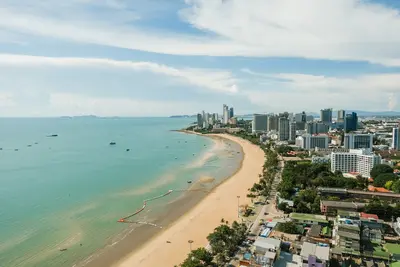
    Pattaya, on the east coast of the Gulf of Thailand, was originally a fishing village. From 1959, US soldiers came here for recreation, and during the Vietnam War, it grew into a resort town. Today, it's a city with high-rises along the beachfront promenade, about 150 kilometers southeast of Bangkok.The Walking Street in the south is the center of nightlife, heavily dominated by bars and red-light establishments. Those wishing to avoid this are better off staying further south in Jomtien or north in Naklua, where it's quieter.Two cultural highlights are: the Sanctuary of Truth in Naklua, a temple built entirely from wood with intricate carvings, and Wat Phra Yai on Pratumnak Hill, offering views over the bay. From Bali Hai Pier, boats depart for Koh Larn island, whose beaches have clearer water than the city beaches.The drier months from November to February are the most pleasant time to travel.
    Khao Sam Roi Yot National Park

    Khao Sam Roi Yot National Park

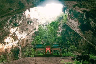
    The Khao Sam Roi Yot National Park is located just under 60 kilometers south of Hua Hin on the Gulf Coast of Prachuap Khiri Khan province. It was established in 1966 as Thailand's first coastal national park and covers around 98 square kilometers, about one-fifth of which is marine area.Limestone mountains, mangroves, the white sand beaches of Laem Sala and Sam Phraya, and Thailand's largest freshwater swamp area characterize the park. The most famous destination is Phraya Nakhon Cave with the Khuha Kharuehat Pavilion, which was built in 1890 for King Chulalongkorn's visit. Through an opening in the cave ceiling, light streams into the cave in the morning.

    Sources & method

    • Photos: Unsplash. Each photo carries its credit.
    • The content is based on web research from public, traceable sources. How the content is made · The role of AI