Silom and Sathorn form Bangkok's business district: two parallel main streets between Lumphini Park and the Chao Phraya, lined with office towers, banks, and embassies.
Silom and Sathorn form Bangkok's business district: two parallel main streets between Lumphini Park and the Chao Phraya, lined with office towers, banks, and embassies. During the day, rush hour traffic and street food stalls in the side streets define the scene.At the eastern end lies Lumphini Park, where Tai Chi groups and joggers are out in the mornings and monitor lizards live by the ponds. On Silom Road stands the Hindu Sri Maha Mariamman Temple with its colorful Gopuram, founded by the Tamil community.In the evenings, life shifts to the Sois: The night market of Patpong, the bars of Soi 4, and restaurants on Convent Road are just a few minutes apart, plus there are rooftop bars in the skyscrapers. Connectivity is good: BTS Sala Daeng and Chong Nonsi, MRT Si Lom and Lumphini. At the river end, the BTS Saphan Taksin station takes you directly to the express boat pier.
Sights in Silom / Sathorn
Discover the most important sights and attractions
1Sri Maha Mariamman Temple (Wat Khaek)
Tamil Hindu temple at the corner of Silom and Pan Road, founded in 1879 by South Indian immigrants and called Wat Khaek by the Thais. Above the entrance stands a multi-tiered Gopuram with colorfully painted deity figures. The temple is in full operation: offerings, bells, flower garlands. Take off shoes, cover shoulders, no photography inside.
A white library building from 1922 on Surawong Road, endowed by Thomas Hays in memory of his wife Jennie Neilson Hays and designed in the neoclassical style by Mario Tamagno. Inside, an English-language library with a reading room under a dome. One of the quietest places in the district.
Bangkok's first public park, around 57 hectares, on land King Rama VI donated in 1925, on the eastern edge of Silom and Sathorn. Running paths circle an artificial lake with rental boats, outdoor gym, and morning Tai Chi/aerobics groups. Monitor lizards live in the water and on the banks. Keep your distance and do not feed them. MRT stations Lumphini and Si Lom are at its edge.
The Thai Red Cross Snake Farm, opened in 1923, is part of the institute that produces antivenom from snake venom. At fixed times, there are venom extraction demonstrations and an exhibition on Thailand's venomous snakes. More factual than the name suggests. Check show times beforehand.
The two alleys between Silom and Surawong, once a pleasure quarter for US soldiers during the Vietnam War, now offer two things: an evening souvenir market mid-alley, and a red-light district in the surrounding buildings. If you only want the market, walk straight through. Offers to go upstairs frequently lead to inflated bills.
Fresh market with street food stalls on Silom Road, mainly operating in the mornings. Rice dishes, noodle soups, Khanom, fruit, cooked for residents and market vendors. Quieter and cheaper than the section near Sala Daeng.
Around the Hindu Temple Sri Maha Mariamman lies Bangkok’s Indian Quarter, with small eateries for Thali, Dosa, Chapati, and Curries. Vegetarian dishes are easy to find here, a great spot in the center if you want to eat meat-free.
The district eats at fixed times. Weekday lunchtimes, the street food stalls on Convent Road, in the Sois and in the market alleys fill with office workers; some of them are closed on weekends. Added to this are two extremes: the Indian eateries around the Hindu temple and the hotel restaurants and rooftop bars in the towers of Sathorn Road.
Hot Lunch Stalls
At lunchtime, stalls on Convent Road and in the Silom Sois offer rice dishes, noodle soups, curries over rice, and grilled meats. Quick and affordable, many then pack up.
South Indian Food
Around Pan Road is the Indian quarter with vegetarian Thali eateries, Dosa, and Chapati. Here, vegetarian food is easier to find than in most Bangkok neighborhoods.
Silom Soi 20
Marktgasse with fresh market and food stalls, mainly morning-active and used by locals. Far fewer travelers than Silom Road's eastern end.
Rooftop bars & hotel restaurants
In the towers on Sathorn Road and by the river, restaurants and bars are located on upper floors. Many have a dress code, such as no shorts and no sandals, and prices are far above street level.
Night Market in Patpong
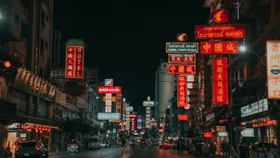
Evenings, the souvenir market emerges between Silom and Surawong. Prices are negotiated.
Office District with Hidden Depths
Silom and Sathorn form Bangkok's financial hub. Banks, insurance companies, law firms, and embassies line Sathorn Road and occupy the high-rises along Silom Road. Sathorn Road runs alongside the Sathorn Canal, dug in 1892, which today serves as a narrow waterway between the two carriageways. The neighborhood's rhythm follows the workweek: sidewalks are bustling on weekdays, but it feels considerably emptier on weekends.Layers of HistoryThe name Silom means "windmill" and recalls a time when fields lay here. Several religious communities have remained from its trading history, located close to each other in the district: the Tamil Hindu temple Sri Maha Mariamman, which Thais call Wat Khaek, alongside mosques, Chinese shrines, and the Indian quarter around Pan Road. A few streets away stand the glass towers.PatpongBetween Silom and Surawong lie Patpong 1 and 2, which became an entertainment district for American soldiers during the Vietnam War. Today, the alley serves two purposes: a night market with souvenir stalls and a red-light district. Offers to come to an upstairs room often result in inflated bills and pressure at checkout.Around Silom Soi 2 and Soi 4, you'll also find a hub of Bangkok's queer bar scene.EtiquetteInside the Hindu temple, remove shoes, cover shoulders, and do not photograph.On weekdays at lunchtime, street food stalls and sidewalks are occupied by office workers. If you prefer a quieter experience, eat before or after.Prostitution is prohibited in Thailand but tolerated. Sexual acts with minors are punishable in Thailand as in Germany, even for offenses committed abroad. For current safety information, please refer to the German Federal Foreign Office.
On-site exploring
Silom and Sathorn are well-connected to public transport: Here, the BTS and MRT intersect, plus there are boat piers along the river. The district is walkable, but you can only cross the wide Sathorn Road at intersections and bridges.BTS Silom Line: Sala Daeng at the eastern end of Silom Road, Chong Nonsi in the middle, Surasak and Saphan Taksin towards the river. Sala Daeng is the usual entry point.MRT Blue Line: Si Lom at the Sala Daeng BTS station with an interchange, Lumphini at the park's southeastern edge and Sam Yan to the north.Skywalk: From Sala Daeng, elevated walkways lead across the intersection. More pleasant than the pavement in rain and midday heat.Express Boat: The Chao Phraya boats stop at Sathorn Pier beneath the Saphan Taksin BTS station. From here, you often get to the Old Town faster than by taxi.On Foot: Between Sala Daeng and Chong Nonsi, it's about fifteen minutes. The side streets are quieter.Taxi: During rush hour, traffic on Silom and Sathorn is gridlocked. Then take the BTS or MRT. Motorcycle taxis can get through, but are risky in heavy traffic.