The Central Lowland is the plain of the Chao Phraya between Nakhon Sawan and the Gulf of Thailand. On this fertile alluvial land, the country's centers of power successively emerged: Dvaravati cities like Nakhon Pathom, then Ayutthaya and finally Bangkok.Destinations include the Ayutthaya Historical Park, the Bang Pa-In Summer Palace, the Khmer structures and the Narai Palace in Lopburi, as well as Phra Pathom Chedi in Nakhon Pathom. Most places are reachable from Bangkok within one to three hours.
The Chao Phraya Plain is the heartland of the Thai state and easily accessible from Bangkok. Many destinations can be visited as a day trip by train or bus. Key attractions include history (Ayutthaya, Lopburi, Nakhon Pathom), canal landscapes and floating markets, and rice cultivation, which shapes the landscape between the cities.
Place 1 of 3
Historical Park Ayutthaya
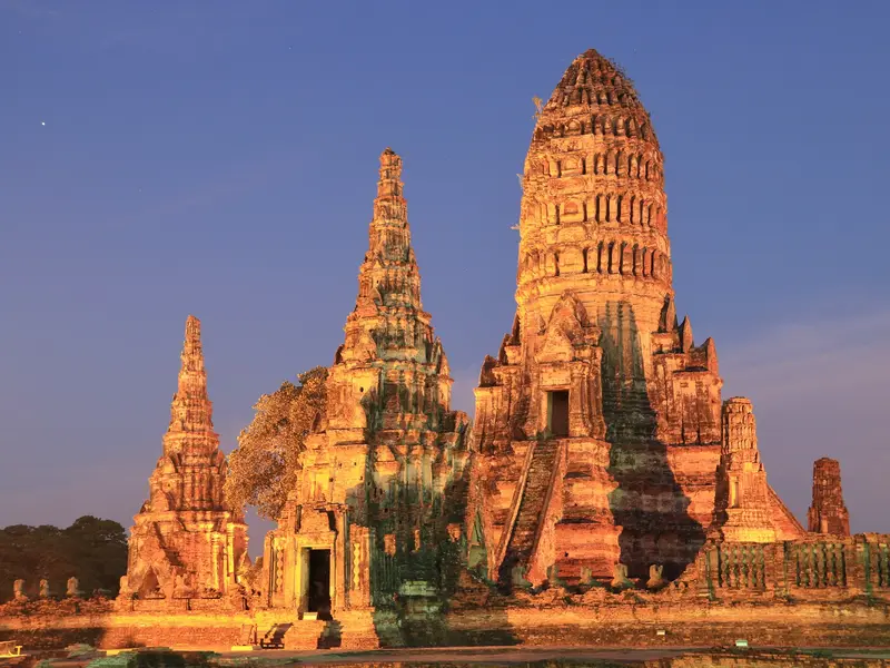
The Ayutthaya Historical Park preserves the remains of the capital of the Kingdom of Siam, founded in 1350 and destroyed in 1767 in a war with Burma.
Lopburi is one of Thailand's ancient cities and famous for its macaques. In the city center, buildings from several eras stand close together: Khmer sanctuaries, Ayutthaya-period temples, and remnants of a 17th-century palace.
Nakhon Pathom, west of Bangkok, was the largest settlement of the Dvaravati culture. Historically, the place is therefore more significant than its current image as a provincial town suggests.
Discover the most important sights and attractions
Ayutthaya Historical Park
The ruins of Ayutthaya, the kingdom's former capital, are located on an island surrounded by three rivers and are a UNESCO World Heritage site. Key highlights include Wat Mahathat, famous for its Buddha head embedded in tree roots, the three Chedi of Wat Phra Si Sanphet, and Wat Chaiwatthanaram by the riverside. The entire complex can be explored by bicycle in one day.
Royal Summer Residence south of Ayutthaya. King Prasat Thong founded the first complex in 1632, with most current buildings added by King Chulalongkorn (1872-1889). Amidst gardens and ponds stand a pavilion set in the water, a Chinese throne hall, and a colorful lookout tower. Palace complexes in Thailand generally have a dress code.
The Chedi in Nakhon Pathom, standing at around 120 meters, is the tallest in Thailand. King Mongkut found the ancient structure in ruins as a monk in 1831 and, after his ascension to the throne, had it rebuilt in the Sri Lankan style, with the complex completed in 1870. At its core lies a monument from the Dvaravati period, when Nakhon Pathom was the largest settlement of this culture. About an hour away from Bangkok.
Central Thailand's largest freshwater swamp and lake area, covering around 224 sq km, is east of Nakhon Sawan near the Ping and Nan river confluence. The wetland is a key habitat for waterfowl; boat trips start from the shore.
Central Thai cuisine is what is internationally mostly known as Thai food: balanced between sweet, salty, sour, and spicy, with coconut milk in the curries, rice as a base, and plenty of fresh vegetables. Access to rivers and the sea, the orchards of the plains, and Chinese trade history have led to a particularly wide variety. Food is eaten at street food stalls, in markets, and in rice restaurants, where you point to ready-made dishes.
Freshwater fish and river prawns
The Chao Phraya and its canals supply fish and large river prawns. In Ayutthaya, there are restaurants that specialize in grilled river prawns.
Boat noodles
Kuay Teow Ruea, the dark, hearty noodle soup that used to be sold from boats. The bowls are small; you order several.
Roti Sai Mai from Ayutthaya
Fine sugar threads wrapped in a soft flatbread, a typical souvenir from Ayutthaya.
Chinese Influences
Dishes like Khao Man Gai, rice with steamed chicken, and Kuay Chap are common in the market streets of provincial towns.
Fruit and palm sugar
Pomelos and other fruits grow in the canal-side orchards; in the south of the plain, palm sugar is made.
Culture and History
The Chao Phraya Plain is Thailand's heartland. At Nakhon Sawan, the Ping and Nan converge, the river flowing about 370 kilometers to the Gulf. This alluvial plain successively birthed power centers: Dvaravati cities like Nakhon Pathom; then Ayutthaya, capital and Asia-Europe trading hub from the 14th to 18th centuries; and ultimately Bangkok, after its 1767 destruction.This rich heritage is visible in a compact area. Ayutthaya boasts palace and monastery ruins amidst residential areas; in Lopburi, Khmer prangs and King Narai's 17th-century palace are superimposed; and Nakhon Pathom's Phra Pathom Chedi traces its origins to a key Dvaravati-era site.Water shapes daily life. Khlongs long served as primary transport routes, and in Nonthaburi, Pathum Thani, and Samut Songkhram, canal life persists. The region is prone to flooding, as extensively seen in 2011.Rice cultivation shapes the landscape between cities.Diversity defines the plain's history: Chinese merchant families, Portuguese and Persian traders in Ayutthaya, Mon villages, and Muslim communities line the river. Temples, mosques, and Chinese shrines often share the same street.
Locally on the go
The plain is well-connected, with Bangkok as a hub for rail, bus, and air travel. From the capital, most destinations are within a one to three-hour radius. You can reach Ayutthaya by train in about 50 to 90 minutes; Lopburi and Nakhon Pathom are also on regular train lines.The Northern Line from Bangkok follows the river valley via Ayutthaya, Lopburi, and Nakhon Sawan to Phitsanulok and Chiang Mai. To the west, the route runs via Nakhon Pathom. Buses and minivans operate more frequently but are more dependent on traffic.Within Towns: You can get around with Songthaew, Tuk-Tuk, or motorcycle taxi. In Ayutthaya, bicycles are practical because the Historical Park is located on a river island.By Water: In Bangkok and Nonthaburi, boats operate on the Chao Phraya, as do longtail boats in the khlongs. The market in Damnoen Saduak is liveliest in the morning, while the market in Amphawa takes place from Friday to Sunday from the afternoon onwards.By Car: The plain is comfortable to navigate by car. Expect long traffic jams in and around Bangkok, especially on Friday evenings and before public holidays.From November to February, it is dry and more pleasant, making it the best time for the shadeless ruin fields. From March to May, it gets very hot. During the rainy season, there are short, heavy showers, and water can stand in low-lying areas.