Fernweh: Home
    ExploreTravel GuidesPlan a tripMy tripLast visited
    de|en
    All Places & RegionsAll highlightsAbout FernwehFAQPrivacy PolicyImprint
    ExploreTravel GuidesPlan a tripMy tripLast visited
    Phu Thap Boek

    Thailand

    Phu Thap Boek

    Point of InterestCulture

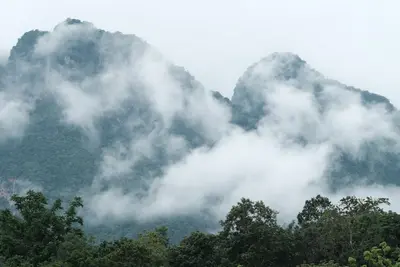
    Phu Thap Boek, at around 1,770 meters, is the highest point in Phetchabun province and the Phetchabun Mountains. The mountain is located in Lom Kao district near the border with Loei province, surrounded by Phu Hin Rong Kla National Park.

    by Felix Gillen

    1. Home
    2. Destinations
    3. Thailand
    4. Phetchabun Mountains
    5. Phu Thap Boek
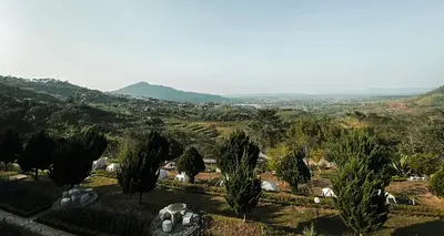
    Phu Thap Boek, at around 1,770 meters, is the highest point in Phetchabun province and the Phetchabun Mountains. The mountain is located in Lom Kao district near the border with Loei province, surrounded by Phu Hin Rong Kla National Park. From the ridge, the view stretches over the surrounding mountain ranges; in the mornings, fog often gathers in the valleys.The slopes are covered with cabbage fields, cultivated by the Hmong families of Ban Thap Boek village. Around these fields, many resorts, campsites, and local eateries have sprung up, some of which are considered illegally built. Many visitors stay overnight here to witness the sunrise.The climate is cool year-round, with December and January being the coldest months. Wild cherry trees also bloom during this time. Warm clothing is advisable even in the dry season.

    Sehenswürdigkeiten

    Discover the most important sights and attractions

    1Phu Thap Boek Viewpoint

    The main viewpoint on the ridge. With clear air, the view extends over several mountain ranges; in cooler months, fog often lies in the valleys in the mornings. It gets crowded for sunrise, and the access road is narrow accordingly.
    Open in Google Maps

    2Ridge Weather Station

    Small building on the ridge where temperatures are measured. Unremarkable as a structure, yet a landmark on the crest.
    Open in Google Maps

    3Terraced Cabbage Fields

    The slopes below the ridge are planted with cabbage, extending up into the steep sections, in narrow terraces along the contour lines. This pattern is the motif for which the mountain is known in Thailand. These are cultivated fields, not a facility for visitors: stay on the paths and do not step between the rows.
    Open in Google Maps

    4Hmong Village Thap Boek

    Mountain Hmong village, residents live mainly from cabbage farming. Alongside homes and fields are shops and simple eateries. A working community, not an open-air museum.
    Open in Google Maps

    Essen & Trinken

    1

    Lan Mae Kamrai (Nong Eve)

    Restaurant in W4G9+PF3.
    Show on Google Maps
    2

    Thap Boek Yen Ta Fo

    Restaurant in 41 Tambon Wang Ban.
    Show on Google Maps
    3

    Ran Mueang Nuea (Phu Thap Boek)

    Restaurant in 106 Tambon Wang Ban.
    Show on Google Maps
    4

    Rung-Chai (affordable cookshop)

    Restaurant in W4FC+H4V.
    Show on Google Maps

    Toni Restaurant

    Restaurant in ทับเบิก ชัวร์ รีสอร์ท Tambon Wang Ban.
    Show on Google Maps

    Food and Drink

    The menu on the mountain is simple and geared towards campers: noodle soups, rice dishes, grilled skewers and hot drinks, along with market stalls featuring local harvests. Evenings, kitchens close early, so anyone arriving late should bring something.

    Cabbage from the fields

    Produce from the slopes is served in the mountain eateries, e.g., fried with garlic or in clear soups.

    Hot Soups and Beverages

    In the cool morning temperatures, noodle soups, coffee, and hot ginger tea are popular at the viewpoints.

    Supplies from Lom Kao

    On the mountain, options are limited; in Lom Kao there are markets and shops.

    People and Agriculture

    The residents of Ban Thap Boek are predominantly Hmong, who migrated here from northern Thailand. Their livelihood is closely linked to agriculture in the highlands, especially cabbage farming, for which the cool climate is ideally suited.Tourism has emerged over recent decades, bringing resorts, campsites, and eateries to the slopes. The fields are a living, not a backdrop: stay on the paths. When in the village, remember it's a home: ask before photos, don't enter courtyards without invitation.

    Directions and On-site

    The summit is located approximately 12 kilometers west of Highway 203, between Loei and Phetchabun. The road ascending from Lom Kao is steep and winding; large buses are unsuitable. A private car or a well-maintained van is recommended. Another route leads from Nakhon Thai through Phu Hin Rong Kla National Park.Use engine braking when descending and drive slowly in fog. You can find road safety information at the German Foreign Office.At the top, you'll travel on foot; the paths are unpaved and slippery after rain. For a night in a tent, you'll need a jacket, a hat, and a warm sleeping bag. Shops and gas stations are located down in Lom Kao, so bring cash and water.The end of the rainy season through early winter is sought after for its fog and green scenery; December and January for the cherry blossoms.

    Accommodations in Phu Thap Boek

    Find perfect stay in Phu Thap Boek

    Booking.com* (Affiliate link)
    Search Hotels
    Agoda* (Affiliate link)
    Search Hotels
    Airbnb
    Vacation Rentals

    * Affiliate link: if you book through it, we earn a small commission. The price stays the same for you.

    Nearby

    Phetchabun Mountains

    Phetchabun Mountains

    The Phetchabun Mountain Region lies in the Pa Sak Valley, about 350 km north of Bangkok, flanked by mountain ranges east and west. Higher elevations around Khao Kho and Phu Thap Boek are cooler than the lowlands; during the cool season, morning fog often blankets the valleys.The region is especially popular with Thai weekend guests; international visitors are rare. Destinations include the ceramic-clad temple Wat Phra That Pha Sorn Kaew, Nam Nao National Park, and in the south, the UNESCO World Heritage Site Si Thep.
    Khao Kho

    Khao Kho

    Khao Kho in Phetchabun Province is a mountainous district with a cool climate, known as Thailand's Switzerland for its beautiful landscapes. In the cool season, mornings often bring fog to the valleys.Notable sites include the temple Wat Phra That Pha Sorn Kaew with five tiered white Buddha figures and ceramic mosaics, the wind farm at around 1,000 meters, and the monument for the fallen of the battles between army and communist insurgents from 1968 to 1982.For this sprawling mountain region, your own vehicle is essential. The most popular travel time is November to February.
    Thung-Salaeng-Luang National Park

    Thung-Salaeng-Luang National Park

    The Thung Salaeng Luang National Park spans approximately 1,260 square kilometers across Phitsanulok and Phetchabun provinces and was designated in 1963 as one of Thailand's first national parks. Its characteristic feature is vast grasslands between pine and mixed forests, a savanna landscape rarely found in Thailand.The open plains, such as Thung Salaeng Luang, covering about 10 square kilometers, and Thung Non Son, with its pines and wildflowers, are the most famous destinations. From October to February, morning fog often blankets the savanna. Well over 100 bird species have been counted.In the north of the park lies the tiered Kaeng Sopha Waterfall near Route 12. You can stay overnight in bungalows or at the park administration's campsites.
    Nam-Nao National Park

    Nam-Nao National Park

    The Nam Nao National Park straddles the border of Phetchabun and Chaiyaphum provinces. Established in 1972, it covers approximately 970 square kilometers. Its highland terrain features a mix of pine forests, dry and mountain forests, and grasslands, giving the park a distinct character compared to the tropical parks in the south.Among its inhabitants are wild elephants, gaur, bantengs, and Sambar deer, plus around 360 bird species. Trails lead to viewpoints, waterfalls such as Haew Sai, and caves. The highest point is Phu Pha Chit, at 1,271 meters.Route 12, connecting Lom Sak and Chum Phae, passes through the park, ensuring easy access. The park headquarters offers bungalows and a campsite. Nights can get noticeably cool, particularly in December and January.

    Sukhothai Historical Park

    Sukhothai Historical Park

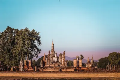
    The Sukhothai Historical Park preserves the remains of the first capital of the Sukhothai Kingdom, which flourished in the 13th and 14th centuries. UNESCO inscribed the site, along with the historical cities of Si Satchanalai and Kamphaeng Phet, on the World Heritage List.The site is divided into several zones. In the center, within the old city walls and moats, stands Wat Mahathat with its lotus-bud-shaped chedi; nearby are Wat Si Sawai with three Khmer-style prangs and Wat Sa Si on an island in the pond. To the north, Wat Si Chum houses the mighty seated Buddha Phra Achana within a narrow masonry shaft.As the zones are spread out, most visitors explore the park by *bicycle*; rentals are available at the entrances. Mornings and late afternoons are much more pleasant than the midday heat. The Ramkhamhaeng National Museum on the park's edge historically contextualizes the finds.

    Sources & method

    • Photos: Unsplash. Each photo carries its credit.
    • The content is based on web research from public, traceable sources. How the content is made · The role of AI