Fernweh: Home
    ExploreTravel GuidesPlan a tripMy tripLast visited
    de|en
    All Places & RegionsAll highlightsAbout FernwehFAQPrivacy PolicyImprint
    ExploreTravel GuidesPlan a tripMy tripLast visited
    Nam-Nao National Park

    Thailand

    Nam-Nao National Park

    National Park

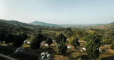
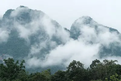
    The Nam Nao National Park straddles the border of Phetchabun and Chaiyaphum provinces. Established in 1972, it covers approximately 970 square kilometers.

    by Felix Gillen

    1. Home
    2. Destinations
    3. Thailand
    4. Phetchabun Mountains
    5. Nam-Nao National Park
    The Nam Nao National Park straddles the border of Phetchabun and Chaiyaphum provinces. Established in 1972, it covers approximately 970 square kilometers. Its highland terrain features a mix of pine forests, dry and mountain forests, and grasslands, giving the park a distinct character compared to the tropical parks in the south.Among its inhabitants are wild elephants, gaur, bantengs, and Sambar deer, plus around 360 bird species. Trails lead to viewpoints, waterfalls such as Haew Sai, and caves. The highest point is Phu Pha Chit, at 1,271 meters.Route 12, connecting Lom Sak and Chum Phae, passes through the park, ensuring easy access. The park headquarters offers bungalows and a campsite. Nights can get noticeably cool, particularly in December and January.

    Sehenswürdigkeiten

    Discover the most important sights and attractions

    Pine Forest Dong Paek

    One of the park's pine forests, where the trees stand widely spaced and the ground is covered with needles. A forest scene you'll find in Thailand only at a few high altitudes. Ask at the park administration for directions.
    Open in Google Maps

    Namtok Heo Sai

    Approx. 20-meter-high waterfall with a pool, about 700 meters off the road. The access point is approx. 17.5 kilometers east of the checkpoint on Route 12. It has the most water during the rainy season.
    Open in Google Maps

    Tham Yai Nam Nao Cave

    An almost 10-kilometer-long cave system with five entrances, accessible via a hike of about 3 kilometers from the nearest ranger station. Prior to your visit, check with the park administration, and bring a headlamp and sturdy shoes.
    Open in Google Maps

    At 1,271 meters, the park's highest point. A steep 6-kilometer trail begins at Route 12; a park permit is required for the hike. The trail was recently closed for forest recovery, so please check with the administration in advance for its current status.
    Open in Google Maps

    Essen & Trinken

    Kuaitiao Ruea Nong Phak Bung (Boat Noodles)

    Restaurant in 1 หมู่ที่ 7 Tambon Wang Kwang.
    Show on Google Maps

    Park Entry Noodle Soup Kitchen

    Restaurant in 39 ม.7 ต.บ้านฟองใต้ อ Tambon Wang Kwang.
    Show on Google Maps

    Eating and Drinking

    Supplies within the park are scarce: a canteen at the administration, plus individual stalls along Route 12. Those camping or hiking early should shop in Lom Sak or Chum Phae instead. The local cuisine is already Isan — sticky rice, papaya salad, and grilled meats define the menus.

    Som Tam & Sticky Rice

    Papaya salad with lime and chili, served with sticky rice. A reliable and affordable meal in the towns bordering the park. If you are sensitive, order it mild.

    Kai Yang

    Marinated charcoal-grilled chicken, often sold at rest stops along Route 12. Good as provisions for a day in the park.

    Dining at Park Administration

    The park administration offers simple rice and noodle dishes. For the evening, it's advisable to bring your own food.

    Arrival and On-Site

    Route 12 runs through the park. Buses between Khon Kaen and Lom Sak or Phetchabun stop at the checkpoint; from there, it's just under two kilometers to the park headquarters, which is about 50 kilometers east of Lom Sak. Having your own vehicle makes you much more flexible, as the attractions are spread far apart.The park is open daily from 8 AM to 4:30 PM and closes every year in June for one month. Admission was last 200 Baht for foreign adults and 100 Baht for children, plus a vehicle fee. Bring cash.For the trail to Phu Pha Chit, you need a permit from the park headquarters; it was recently closed for forest recovery. Inquire locally about which trails are open. Wild elephants live in the area: keep your distance, give them right of way, and drive slowly at dusk, as animals may cross the road.Hiking boots, rain gear, and protection against leeches during the rainy season are advisable.

    Accommodations in Nam-Nao National Park

    Find perfect stay in Nam-Nao National Park

    Booking.com* (Affiliate link)
    Search Hotels
    Agoda* (Affiliate link)
    Search Hotels
    Airbnb
    Vacation Rentals

    * Affiliate link: if you book through it, we earn a small commission. The price stays the same for you.

    Nearby

    Phu Thap Boek

    Phu Thap Boek

    Phu Thap Boek, at around 1,770 meters, is the highest point in Phetchabun province and the Phetchabun Mountains. The mountain is located in Lom Kao district near the border with Loei province, surrounded by Phu Hin Rong Kla National Park. From the ridge, the view stretches over the surrounding mountain ranges; in the mornings, fog often gathers in the valleys.The slopes are covered with cabbage fields, cultivated by the Hmong families of Ban Thap Boek village. Around these fields, many resorts, campsites, and local eateries have sprung up, some of which are considered illegally built. Many visitors stay overnight here to witness the sunrise.The climate is cool year-round, with December and January being the coldest months. Wild cherry trees also bloom during this time. Warm clothing is advisable even in the dry season.
    Phetchabun Mountains

    Phetchabun Mountains

    The Phetchabun Mountain Region lies in the Pa Sak Valley, about 350 km north of Bangkok, flanked by mountain ranges east and west. Higher elevations around Khao Kho and Phu Thap Boek are cooler than the lowlands; during the cool season, morning fog often blankets the valleys.The region is especially popular with Thai weekend guests; international visitors are rare. Destinations include the ceramic-clad temple Wat Phra That Pha Sorn Kaew, Nam Nao National Park, and in the south, the UNESCO World Heritage Site Si Thep.
    Khao Kho

    Khao Kho

    Khao Kho in Phetchabun Province is a mountainous district with a cool climate, known as Thailand's Switzerland for its beautiful landscapes. In the cool season, mornings often bring fog to the valleys.Notable sites include the temple Wat Phra That Pha Sorn Kaew with five tiered white Buddha figures and ceramic mosaics, the wind farm at around 1,000 meters, and the monument for the fallen of the battles between army and communist insurgents from 1968 to 1982.For this sprawling mountain region, your own vehicle is essential. The most popular travel time is November to February.
    Thung-Salaeng-Luang National Park

    Thung-Salaeng-Luang National Park

    The Thung Salaeng Luang National Park spans approximately 1,260 square kilometers across Phitsanulok and Phetchabun provinces and was designated in 1963 as one of Thailand's first national parks. Its characteristic feature is vast grasslands between pine and mixed forests, a savanna landscape rarely found in Thailand.The open plains, such as Thung Salaeng Luang, covering about 10 square kilometers, and Thung Non Son, with its pines and wildflowers, are the most famous destinations. From October to February, morning fog often blankets the savanna. Well over 100 bird species have been counted.In the north of the park lies the tiered Kaeng Sopha Waterfall near Route 12. You can stay overnight in bungalows or at the park administration's campsites.
    Udon Thani

    Udon Thani

    Udon Thani, a major city in northern Isan, serves as an ideal starting point for exploring the UNESCO World Heritage Site Ban Chiang Archaeological Site and itself offers a lively market scene and relaxed parks.

    Sources & method

    • Photos: Pexels. Each photo carries its credit.
    • The content is based on web research from public, traceable sources. How the content is made · The role of AI