Fernweh: Home
    ExploreTravel GuidesPlan a tripMy tripLast visited
    de|en
    All Places & RegionsAll highlightsAbout FernwehFAQPrivacy PolicyImprint
    ExploreTravel GuidesPlan a tripMy tripLast visited
    Thung-Salaeng-Luang National Park

    Thailand

    Thung-Salaeng-Luang National Park

    National Park

    The Thung Salaeng Luang National Park spans approximately 1,260 square kilometers across Phitsanulok and Phetchabun provinces and was designated in 1963 as one of Thailand's first national parks.

    by Felix Gillen

    1. Home
    2. Destinations
    3. Thailand
    4. Phetchabun Mountains
    5. Thung-Salaeng-Luang National Park
    The Thung Salaeng Luang National Park spans approximately 1,260 square kilometers across Phitsanulok and Phetchabun provinces and was designated in 1963 as one of Thailand's first national parks. Its characteristic feature is vast grasslands between pine and mixed forests, a savanna landscape rarely found in Thailand.The open plains, such as Thung Salaeng Luang, covering about 10 square kilometers, and Thung Non Son, with its pines and wildflowers, are the most famous destinations. From October to February, morning fog often blankets the savanna. Well over 100 bird species have been counted.In the north of the park lies the tiered Kaeng Sopha Waterfall near Route 12. You can stay overnight in bungalows or at the park administration's campsites.

    Sehenswürdigkeiten

    Discover the most important sights and attractions

    1Viewpoint Sala Dusita

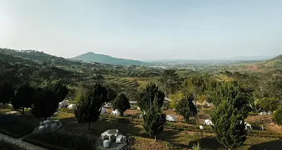
    Park pavilion with views of open land and forest ridges. Most beautiful early morning, when haze lies over the landscape in the cooler season.
    Open in Google Maps

    2Khao Takhian Ngo Viewpoint

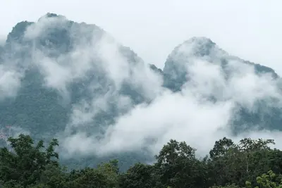
    Viewpoint on a hill at the eastern edge of the park, towards Khao Kho. From the summit, you look out over the forest areas of the protected area and the Phetchabun mountain ranges; mornings often bring fog to the valleys.
    Open in Google Maps

    3Kaeng Sopha

    Tiered waterfall on the Wang Thong River in the north of the park, about 2.5 kilometers off Route 12 and therefore the most visited spot. Open from 8 AM to 4 PM. During the rainy season, the current is very strong, then do not go into the water.
    Open in Google Maps

    4Grass Plain Thung Salaeng Luang

    The approximately 10-square-kilometer savanna that gives the park its name: open grassland nestled between forest islands, a landscape form rare in Thailand. From October to February, mornings often bring fog over the area, with excellent views from Nong Mae Na campsite.
    Open in Google Maps

    5Namtok Sri Dit

    A single-tier, year-round waterfall, approx. 12 km from park headquarters, accessible via Highway 2235.
    Open in Google Maps

    6

    Grassland inside the park with pines and wildflowers. The access road is partly unpaved and has restricted access during the rainy season; check with park management first.
    Open in Google Maps

    Essen & Trinken

    1

    Baan Rom Sai (Khrua Parichat)

    Restaurant in 156 Tambon Nong Mae Na.
    Show on Google Maps
    2

    Sa Morakot (Khao Kho)

    Restaurant in 102 หมู่ 6 Tambon Nong Mae Na.
    Show on Google Maps
    3

    Khrua Che Nga

    Restaurant in HWPR+GHF.
    Show on Google Maps
    4

    Kinsen (Nong Pin)

    Restaurant in 2258.
    Show on Google Maps

    Food & Beverage

    There is hardly any catering in the park: a canteen at the administration area and stalls at the entrances to Kaeng Sopha. Along Route 12 and towards Khao Kho, however, there are many simple restaurants and scenic eateries, primarily catering to Thai weekend guests.

    Ahan Tam Sang

    Cooked to order: fried rice, noodles, egg with basil, chili stir-fries. Fast, affordable, and widely available on Route 12.

    Som Tam and Kai Yang

    Papaya salad and grilled chicken with sticky rice, available at many rest stops and market stalls in the region. Good as provisions for a day in the park.

    Catering in the Park

    The administration offers basic meals and drinks with early closing hours. Those heading to the grassland should get water and food beforehand.

    Arrival and On-Site

    Route 12 between Phitsanulok and Lom Sak leads through the northern part of the park; Kaeng Sopha Waterfall is about 2.5 kilometers off the main route. To reach the park administration, take Highways 21 and 2258. There is no public transport into the park; you will need your own vehicle or a transfer.The grasslands are located deep within the park, accessible via partly unpaved tracks. During the rainy season, they are only partially navigable; inquire at the administration about road conditions.The last reported entrance fee was 200 Baht for foreign adults and 100 Baht for children, plus a vehicle fee. The attractions are far apart, so plan for a full day; bring water, provisions, and cash. The nearest larger towns are Wang Thong to the west and Lom Sak to the east.

    Accommodations in Thung-Salaeng-Luang National Park

    Find perfect stay in Thung-Salaeng-Luang National Park

    Booking.com* (Affiliate link)
    Search Hotels
    Agoda* (Affiliate link)
    Search Hotels
    Airbnb
    Vacation Rentals

    * Affiliate link: if you book through it, we earn a small commission. The price stays the same for you.
    Nearby

    Khao Kho

    Khao Kho

    Khao Kho in Phetchabun Province is a mountainous district with a cool climate, known as Thailand's Switzerland for its beautiful landscapes. In the cool season, mornings often bring fog to the valleys.Notable sites include the temple Wat Phra That Pha Sorn Kaew with five tiered white Buddha figures and ceramic mosaics, the wind farm at around 1,000 meters, and the monument for the fallen of the battles between army and communist insurgents from 1968 to 1982.For this sprawling mountain region, your own vehicle is essential. The most popular travel time is November to February.
    Phetchabun Mountains

    Phetchabun Mountains

    The Phetchabun Mountain Region lies in the Pa Sak Valley, about 350 km north of Bangkok, flanked by mountain ranges east and west. Higher elevations around Khao Kho and Phu Thap Boek are cooler than the lowlands; during the cool season, morning fog often blankets the valleys.The region is especially popular with Thai weekend guests; international visitors are rare. Destinations include the ceramic-clad temple Wat Phra That Pha Sorn Kaew, Nam Nao National Park, and in the south, the UNESCO World Heritage Site Si Thep.
    Phu Thap Boek

    Phu Thap Boek

    Phu Thap Boek, at around 1,770 meters, is the highest point in Phetchabun province and the Phetchabun Mountains. The mountain is located in Lom Kao district near the border with Loei province, surrounded by Phu Hin Rong Kla National Park. From the ridge, the view stretches over the surrounding mountain ranges; in the mornings, fog often gathers in the valleys.The slopes are covered with cabbage fields, cultivated by the Hmong families of Ban Thap Boek village. Around these fields, many resorts, campsites, and local eateries have sprung up, some of which are considered illegally built. Many visitors stay overnight here to witness the sunrise.The climate is cool year-round, with December and January being the coldest months. Wild cherry trees also bloom during this time. Warm clothing is advisable even in the dry season.
    Nam-Nao National Park

    Nam-Nao National Park

    The Nam Nao National Park straddles the border of Phetchabun and Chaiyaphum provinces. Established in 1972, it covers approximately 970 square kilometers. Its highland terrain features a mix of pine forests, dry and mountain forests, and grasslands, giving the park a distinct character compared to the tropical parks in the south.Among its inhabitants are wild elephants, gaur, bantengs, and Sambar deer, plus around 360 bird species. Trails lead to viewpoints, waterfalls such as Haew Sai, and caves. The highest point is Phu Pha Chit, at 1,271 meters.Route 12, connecting Lom Sak and Chum Phae, passes through the park, ensuring easy access. The park headquarters offers bungalows and a campsite. Nights can get noticeably cool, particularly in December and January.
    Sukhothai Historical Park

    Sukhothai Historical Park

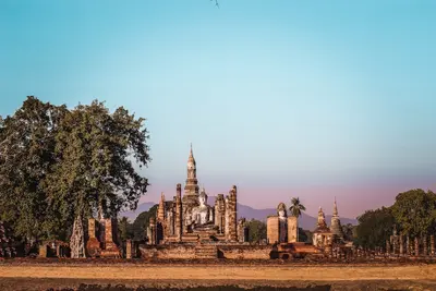
    The Sukhothai Historical Park preserves the remains of the first capital of the Sukhothai Kingdom, which flourished in the 13th and 14th centuries. UNESCO inscribed the site, along with the historical cities of Si Satchanalai and Kamphaeng Phet, on the World Heritage List.The site is divided into several zones. In the center, within the old city walls and moats, stands Wat Mahathat with its lotus-bud-shaped chedi; nearby are Wat Si Sawai with three Khmer-style prangs and Wat Sa Si on an island in the pond. To the north, Wat Si Chum houses the mighty seated Buddha Phra Achana within a narrow masonry shaft.As the zones are spread out, most visitors explore the park by *bicycle*; rentals are available at the entrances. Mornings and late afternoons are much more pleasant than the midday heat. The Ramkhamhaeng National Museum on the park's edge historically contextualizes the finds.

    Sources & method

    • Photos: Pexels. Each photo carries its credit.
    • The content is based on web research from public, traceable sources. How the content is made · The role of AI