Thailand
Sukhothai Historical Park
Point of InterestCulture
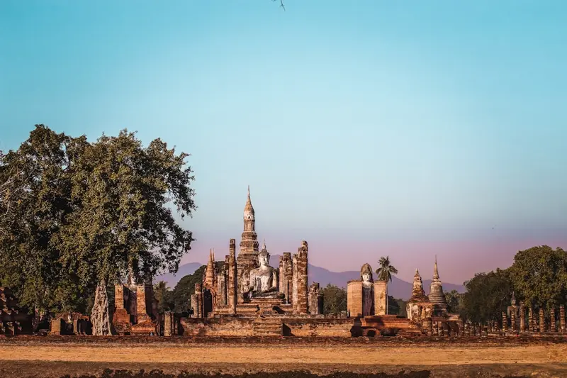
The Sukhothai Historical Park preserves the remains of the first capital of the Sukhothai Kingdom, which flourished in the 13th and 14th centuries.
by Felix Gillen
The Sukhothai Historical Park preserves the remains of the first capital of the Sukhothai Kingdom, which flourished in the 13th and 14th centuries. UNESCO inscribed the site, along with the historical cities of Si Satchanalai and Kamphaeng Phet, on the World Heritage List.The site is divided into several zones. In the center, within the old city walls and moats, stands Wat Mahathat with its lotus-bud-shaped chedi; nearby are Wat Si Sawai with three Khmer-style prangs and Wat Sa Si on an island in the pond. To the north, Wat Si Chum houses the mighty seated Buddha Phra Achana within a narrow masonry shaft.As the zones are spread out, most visitors explore the park by *bicycle*; rentals are available at the entrances. Mornings and late afternoons are much more pleasant than the midday heat. The Ramkhamhaeng National Museum on the park's edge historically contextualizes the finds.
Sehenswürdigkeiten
Discover the most important sights and attractions
Wat Si Chum
North of the city wall sits Buddha Phra Achana, roughly 15 meters high and 11 meters wide, within an almost enclosed Mondop featuring 15-meter high walls. Through a narrow slit in the front, you can glimpse its face and hand even from the outside. The confined space feels quite different from the open ruins in the center.
Wat Si Sawai
Three prangs southwest of Wat Mahathat, whose lower parts are built in Khmer style. The complex originated in the late 12th or early 13th century as a Hindu shrine to Vishnu, the three towers symbolize the Hindu Trinity; later it was used for Buddhist purposes.
Wat Saphan Hin
Temple on an about 200-meter-high hill in the West Zone, accessible via a path and slate slab stairs that gave the temple its name. At the top stands the about 12.5-meter-tall standing Buddha Phra Attharot, with views across the plain to the Old City.
Ramkhamhaeng National Museum
Museum on the edge of the central zone, displaying sculptures, ceramics, and inscriptions from the city area and explaining its construction phases. Recommended as a first stop before heading to the ruins.
Essen & Trinken
Food and Drinks
Around the park, you'll find simple food stalls and noodle shops along the road in Mueang Kao; a wider selection is available in the new city. The region boasts its own unique dish, Sukhothai noodles, which is rarely found on other menus.
Kuai Tiao Sukhothai
The local noodle soup: Rice noodles with pork, long beans, roasted peanuts, and a lightly sweet and sour broth. Prepared in many shops around the park and in the new city.
Sticky rice and Som Tum
Kluai Thot
Fried banana slices in batter, sold at roadside stalls. An affordable stop on your bike tour, best fresh from the pan.
Market in Mueang Kao
The small market near the old town primarily serves the residents, but in the mornings it also offers curries, grilled skewers, and fruit for takeaway. Practical for grabbing provisions for a day in the park.
History and Significance
First Kingdom of the ThaiSukhothai was the capital of an early Siamese kingdom in the 13th and 14th centuries. Previously, the area was under Khmer influence: The Wat Si Sawai was built as a Hindu shrine for Vishnu in the late 12th or early 13th century. Ramkhamhaeng is considered the most famous ruler, to whom tradition attributes the development of the Thai script.Architectural Forms and World HeritageTypical of the era are the lotus-bud-shaped Chedi, for example at Wat Mahathat, and the walking Buddha. With the rise of Ayutthaya, the city lost its importance; in 1793, Rama I. founded the new Sukhothai about twelve kilometers to the east; the old city was abandoned. Since 1991, the ruins, along with Si Satchanalai and Kamphaeng Phet, have been on the UNESCO World Heritage List. The site is restored and partly reconstructed.
Exploring Locally
In the ParkThe grounds are vast and divided into several zones: the Central Zone within the walls, plus North, West, East, and South. Only the Central Zone is practical to explore on foot.A bicycle is the ideal transport: rental shops are at the entrances and along the road in Mueang Kao; the terrain is flat. Between the Central and North zones it's just a few minutes, but the West Zone with Wat Saphan Hin is considerably further. Plan your visit for early morning or late afternoon, there's little shade at midday.Getting ThereThe park is located near Mueang Kao, about twelve kilometers west of the new city of Sukhothai; Songthaews shuttle between both places during the day. Sukhothai Airport in Sawankhalok district is served by Bangkok Airways from Bangkok-Suvarnabhumi. Phitsanulok, with an airport and train connection, is almost 100 kilometers away; the bus takes one to one and a half hours.In the temple precincts, the following applies: shoulders and knees covered, shoes off where indicated, and do not climb on walls or Buddha figures.
Accommodations in Sukhothai Historical Park
Find perfect stay in Sukhothai Historical Park
Booking.com* (Affiliate link)
Search Hotels
Agoda* (Affiliate link)
Search Hotels
Airbnb
Vacation Rentals
* Affiliate link: if you book through it, we earn a small commission. The price stays the same for you.