Fernweh: Home
    ExploreTravel GuidesPlan a tripMy tripLast visited
    de|en
    All Places & RegionsAll highlightsAbout FernwehFAQPrivacy PolicyImprint
    ExploreTravel GuidesPlan a tripMy tripLast visited
    • Neighborhoods & highlights
    • Walking tours
    • Eat & drink
    • Food culture
    • Culture
    • Nightlife
    • Getting around
    • Accommodation
    • Plan trip
    • Nearby
    Zakynthos (Island)

    Greece

    Zakynthos (Island)

    City

    Zakynthos is the southernmost of the larger Ionian Islands and presents two faces: in the north and west, a rugged coastline with caves and Shipwreck Bay Navagio; in the south, flat sandy beaches where loggerhead sea turtles lay their eggs.

    by Felix Gillen

    1. Home
    2. Destinations
    3. Greece
    4. Ionian Islands
    5. Zakynthos (Island)
    Zakynthos is the southernmost of the larger Ionian Islands and presents two faces: in the north and west, a rugged coastline with caves and Shipwreck Bay Navagio; in the south, flat sandy beaches where loggerhead sea turtles lay their eggs. In between lies a fertile plain with vineyards and olive groves. The Venetians named the island Fior di Levante.

    Sights in Zakynthos (Island)

    Discover the most important sights and attractions

    1Bay of Segounia

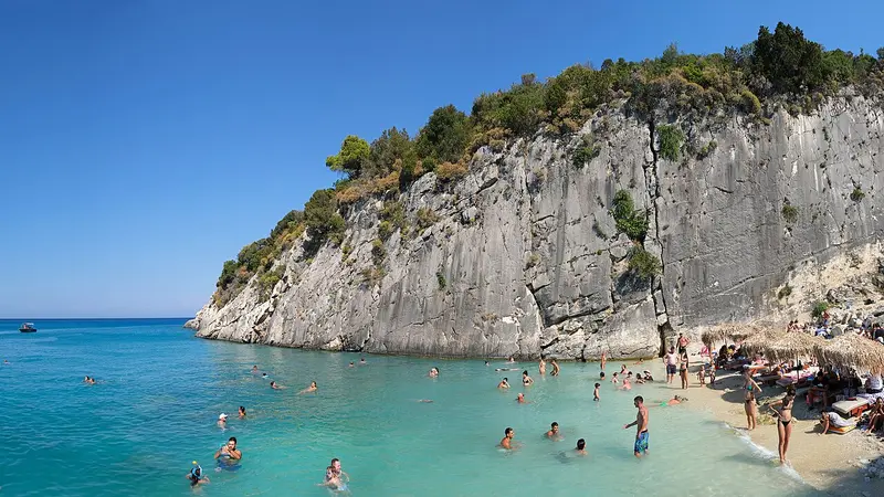
    Segounia is located on the northeast coast between Alykes and Xigia, one of the coves that are barely noticeable from the coastal road. Access is via an unpaved path, with the final stretch on foot.Instead of sand, you'll find rock slabs and coarse pebbles here, but clear water and excellent snorkeling conditions. Infrastructure is completely absent – no sunbeds, canteen, or shade.Bring water, sun protection, and sturdy shoes. With a northerly wind, waves can form in the bay, making the south coast a better option.
    Open in Google Maps
    Xigia Beach

    2Xigia Beach

    Xigia, on the northeast coast, is situated in a narrow bay between high cliffs. Sulfur springs emerge directly from the rock here into the sea, giving the water a milky-turquoise hue and a distinct smell.The spring water is noticeably cooler than the surrounding sea. The beach is small and consists of pebbles; there's a canteen and a few sunbeds.The descent is via a steep staircase from the coastal road; parking is scarce. Next door lies the quieter bay of Pelagaki, which can be reached via the same path.
    Open in Google Maps
    Navagio

    3Navagio

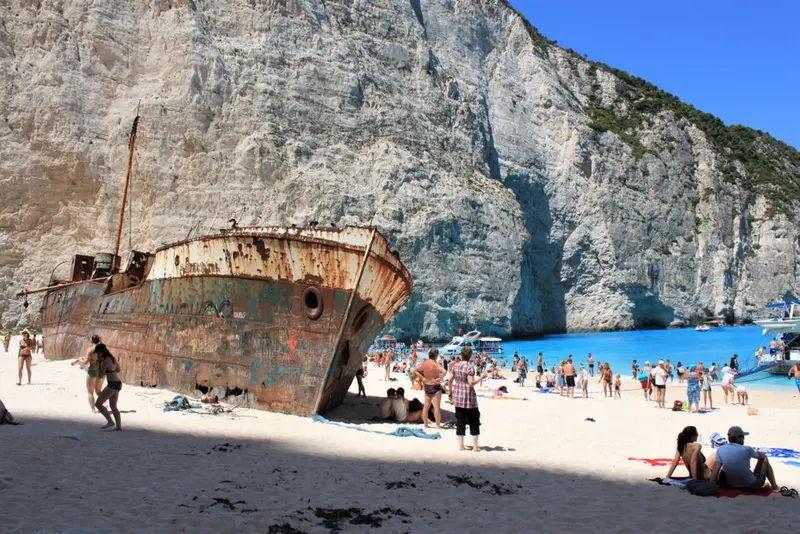
    Navagio, Shipwreck Bay, is located on the northwest coast beneath sheer limestone cliffs. On the bright pebbles lies the hull of the freighter Panagiotis, which ran aground in 1980. There is no land access.Following rockfalls, the beach has been closed to shore visits since 2018. For the 2026 season, until October 31, an entry and swimming ban applies to the beach and bay. Boats are not allowed to approach the coast closer than 50 meters or anchor there. Boat tours from Porto Vromi, Agios Nikolaos, and Zakynthos-Stadt therefore only approach the bay from the outside.The viewpoint above Anafonitria is located directly above the cliff edge and is accessible by road. It is only open when proper safety measures are in place. Check the current status before visiting.
    Open in Google Maps
    Blue Caves at Cape Skinari

    4Blue Caves at Cape Skinari

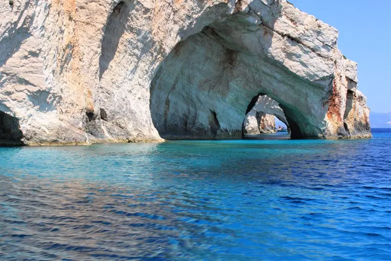
    At the northern tip of the island, the sea has carved a series of arches, niches, and caves into the limestone. Sunlight reflects off the bright seabed, making the water in the cavities appear intensely blue, hence the name Blue Caves.Small boats depart from Agios Nikolaos and from the lighthouse at Cape Skinari; the tour lasts half an hour to an hour depending on the operator. Larger vessels cannot enter the narrower caves.In the early morning, the colour effect is strongest and the sea is calmest. In windy conditions, tours are cancelled; operators decide at short notice.
    Open in Google Maps
    Marathonisi and the Bay of Laganas

    5Marathonisi and the Bay of Laganas

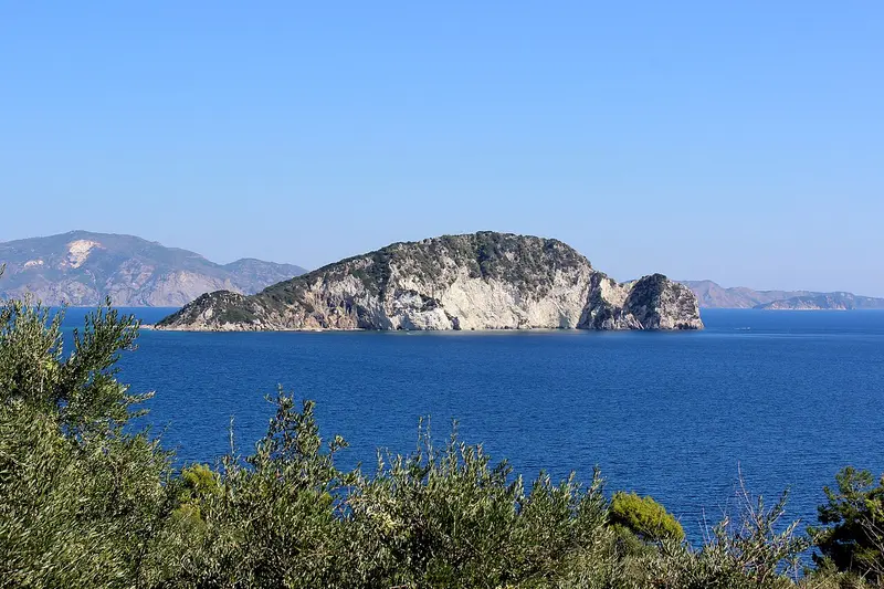
    Laganas Bay is one of the most important breeding grounds for the Loggerhead Sea Turtle in the Mediterranean and has been part of the Zakynthos National Marine Park since 1999. From late May to August, females come ashore at night on the sandy beaches to lay their eggs.Restrictions apply to the core beaches of Sekania, Daphni, and Gerakas: a nightly access ban, and limitations on sunbeds, umbrellas, and lights. Sekania is completely closed.In front of the bay lies the uninhabited island of Marathonisi, known as Turtle Island due to its shape. Boats visit it, but only a limited area on land may be accessed. Designated zones and speed limits apply to boats within the bay.
    Open in Google Maps
    Zakynthos Town and Solomos Square

    6Zakynthos Town and Solomos Square

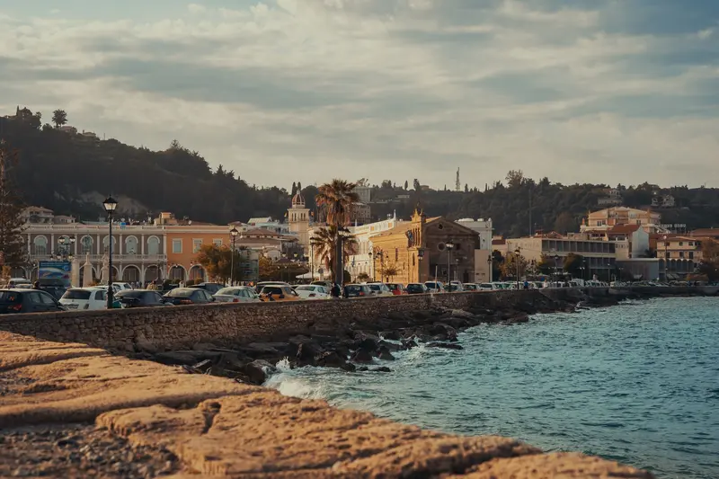
    The 1953 earthquake almost completely destroyed Zakynthos Town. During reconstruction, it was decided to replicate the Venetian cityscape: arcades along the main streets, low eaves, and freestanding bell towers in the Italian style.On Solomos Square by the harbor stands the Byzantine Museum, housing icons and iconostases from destroyed churches, a core collection of the Heptanese School of Painting, which merged Byzantine forms with Western art. The square is named after Dionysios Solomos, who was born here and wrote the lyrics of the Greek national anthem.A few minutes south lies the Church of Agios Dionysios with the shrine of the island's patron saint. The core area can be explored on foot in one to two hours.
    Open in Google Maps

    City walks in Zakynthos (Island)

    Curated walking tours through the city's highlights, handpicked by experienced travel journalists.

    Bochali: Panoramic Views & Venetian Heritage

    On this walk, discover the heights above Zakynthos Town and immerse yourself in the history of Venetian rule. Enjoy breathtaking views over the town and the Ionian Sea as you explore the ruins of the historic castle and stroll through the charming village of Bochali.

    ~1 Std. 30 Min.
    Open in Google Maps
    Stops (6)

    Dining & Drinks

    1

    Botega Café Museum & Taverna

    The family-run establishment in the mountain village of Orthonies in the north of the island combines a café and a taverna with a small folklore museum. On display are tools for making olive oil, wine, flour, honey, and cheese, including an old olive press. The menu features Greek dishes, Greek coffee, and homemade orange cake.
    Show on Google Maps
    2

    Relax Restaurant

    The family restaurant is located on the main road of Alykes in the northeast of the island. It serves Zakynthian and Mediterranean cuisine, including lamb shank braised in red wine and island-style beef stew. From the street-side tables, you can watch village life unfold.
    Show on Google Maps
    3

    Fishαλίδα

    The beach restaurant on the long sandy beach of Alykes has been run by a fishing family since 2013, sourcing fish from their own boats. The cuisine is Mediterranean with a focus on seafood. A converted fishing boat serves as a seating area, serving from breakfast to dinner.
    Show on Google Maps

    Food and Drink

    Zakynthos' cuisine bears an Italian signature: tomato sauces, braised meats, and almond pastries. Complementing this is a wine, whose unique style is found only here.

    Verdea

    The island's traditional white wine, made from indigenous varieties and oxidatively aged, is golden yellow and tart. Its name comes from the Italian for green, indicating an early harvest. Small inland estates serve it.

    Mandolato

    The white nougat with almonds and honey has Venetian origins and is sold in blocks in the capital's confectioneries. Soft and hard varieties are available. Along with sesame Pasteli, it is the classic souvenir.

    Sartsa

    Beef, slow-braised in tomato, garlic, and wine, is one of the Zakynthian Sunday dishes and is served with pasta or potatoes. The sauce is thick and richly seasoned. In inland tavernas, it appears more often on the menu than along the coast.

    Skordostoumbi

    Eggplants braised with plenty of garlic, tomato, and herbs, served lukewarm. This purely plant-based dish originated as fasting food. Order it as Mezes or a side dish.

    Ladotyri and Pasteli from figs

    The island's hard sheep's cheese ripens in olive oil and is served in cubes with wine. Also available are Pastelaria, dried figs pressed into flatbreads with sesame and spices. You'll find both at the market in Zakynthos Town.

    Culture and History of Zakynthos

    Fior di LevanteFrom 1485 to 1797, Zakynthos belonged to Venice, which named the island “Fior di Levante,” Flower of the Levant. The Venetian era shaped its architecture, art, and language: arcades, vaults, and freestanding bell towers modeled after Italian campanili. After the 1953 earthquake, which almost completely destroyed the city, it was rebuilt in this style.Music and LiteratureThe musical tradition includes the polyphonic Kantades and Arekies, accompanied by mandolin and guitar. Born on Zakynthos were the poets Dionysios Solomos, who wrote the lyrics of the Greek national anthem, and Andreas Kalvos, as well as the Italian poet Ugo Foscolo.Heptanese School of PaintingFrom the 17th century onwards, painters of the Ionian Islands combined Byzantine iconography with Western painting. Many works of this Heptanese School, rescued from the destroyed churches, are now displayed at the Byzantine Museum in Solomos Square.

    Nightlife

    1

    Sugarbush Kitchen & Cocktail Bar

    The cocktail bar in Alykes has its own kitchen and is open from daytime until late at night. From 9 PM, regular karaoke, music quizzes, and bingo are on the agenda, along with live sports broadcasts.
    Show on Google Maps

    Getting There and Around on Zakynthos

    Getting ThereThe airport is located a few kilometers south of Zakynthos Town and offers direct flights from Central Europe in summer. Ferries depart from Kyllini on the Peloponnese, reaching Zakynthos Town in about an hour. In summer, there's also a connection from Agios Nikolaos in the north to Kefalonia.Bus, Rental Car and BoatKTEL buses connect Zakynthos Town with Laganas, Tsilivi, Alykes, and Argassi; services to the north and west are infrequent. For Volimes, Cape Skinari, and the viewpoint above Navagio, you'll need your own vehicle. Part of the coast is only visible from the water; boats depart from Porto Vromi, Agios Nikolaos, Skinari, and the town port to the Blue Caves and along the cliffs. Within Laganas Bay, strict zones and speed limits apply in the national park.In TownZakynthos Town can be explored on foot; the core between Solomos Square and Agios Dionysios Church is manageable. A winding road leads to Bochali above the town; the ascent on foot takes around 30 minutes. Taxis are available along the harbor promenade and at the airport.

    Accommodations in Zakynthos (Island)

    Find perfect stay in Zakynthos (Island)

    Booking.com* (Affiliate link)
    Search Hotels
    Agoda* (Affiliate link)
    Search Hotels
    Airbnb
    Vacation Rentals

    * Affiliate link: if you book through it, we earn a small commission. The price stays the same for you.

    Campgrounds in Zakynthos (Island)

    Find perfect campground in Zakynthos (Island)

    Search via Google Maps
    Campgrounds nearby (15km)
    Camping.info
    Find Campgrounds
    Park4Night
    RV Parks & Camping

    Plan your trip to Zakynthos (Island)

    Save places, build a route and plan your city trip, all in one place.

    1. 1
      Sunrise over alpine peaks and a sea of clouds
      1234

      Round trip

      12 days · 4 stops

      Saved

      Pick a route

      Pick a ready-made one or save places and plan your own.

      Open bookmarks
    2. 2

      Trip to Zakynthos (Island)

      Live
      • 1Bay of Segounia3 days
      • 2Xigia Beach4 days
      • 3Navagio5 days
      Budget

      Plan your trip

      The planner sorts stops, days and budget. Plan together in real time.

      Start trip planning
    3. 3
      9:41 No signal
      Zakynthos (Island)
      Available offline

      Use it on the road

      Download the guide to your phone and use it on site, even offline.

    Nearby

    Kefalonia (Island)

    Kefalonia (Island)

    Kefalonia is, at almost 780 square kilometres, the largest of the Ionian Islands and the one with the most rugged relief: Mount Ainos rises to 1,628 metres and is covered with Greek Fir, which is botanically named after the island. Beneath the island lies a karst system where seawater disappears on one side and reappears on the other.In between lie pebble coves like Myrtos, vineyards with the Robola grape variety, and small harbours. The island is large enough for an entire week and can be easily combined with Ithaca.
    Ionian Islands

    Ionian Islands

    The Ionian Islands, west of the mainland, contrast sharply with the Aegean: more rain, more greenery, a Venetian rather than Ottoman past. Seven larger islands, from northern Corfu to southern Kythira, feature cypresses, olive groves, and towns with arcades and bell towers. Here, travelers find limestone cliffs, turquoise water, and Italian cuisine.
    Ancient Olympia

    Ancient Olympia

    Ancient Olympia is located in the region of Elis in the west of the Peloponnese, where the Kladeos flows into the Alpheios. From 776 BC to 393 AD, the Olympic Games were held here every four years in honor of Zeus, for almost twelve centuries. Of the sanctuary, foundations, toppled column drums, and the stadium are preserved; the sculptures are in the museum opposite.
    Lefkada (Island)

    Lefkada (Island)

    Lefkada is accessible without a ferry: A causeway with a floating swing bridge connects the island to the mainland via a narrow canal. It is known for its west coast, where white limestone cliffs plunge steeply into turquoise waters.Behind this lies a mountainous island interior with lentil fields, embroidery traditions, and villages at over 700 meters altitude. On the quieter east coast, boat trips depart to the offshore islands.
    Peloponnese

    Peloponnese

    The Peloponnese hangs off the southern end of the Greek mainland and, strictly speaking, is an island since the construction of the Corinth Canal. Mycenaean castles, the Sanctuary of Olympia, Byzantine ruined cities, and Venetian sea fortresses lie close together here.Between them, mountain ranges rise to over 2,400 meters, with Taygetos reaching 2,407 meters. The coastal roads remain narrow and winding; those who travel the peninsula are better off planning with few base locations and day trips.

    Sources & method

    • Photos: Wikimedia Commons, Unsplash, Pexels. Each photo carries its credit.
    • Place data such as addresses and ratings comes from Google Maps.
    • The content is based on web research from public, traceable sources. How the content is made · The role of AI