Fernweh: Home
    ExploreTravel GuidesPlan a tripMy tripLast visited
    de|en
    All Places & RegionsAll highlightsAbout FernwehFAQPrivacy PolicyImprint
    ExploreTravel GuidesPlan a tripMy tripLast visited
    • Neighborhoods & highlights
    • Recommendations
    • Eat & drink
    • Culture
    • Getting around
    • Accommodation
    • Plan trip
    • Nearby
    Ninh Binh

    Vietnam

    Ninh Binh

    City

    Ninh Bình is a city in the southern Red River Delta, about two hours by bus or train south of Hanoi.

    by Felix Gillen

    1. Home
    2. Destinations
    3. Vietnam
    4. Northern Vietnam
    5. Ninh Binh
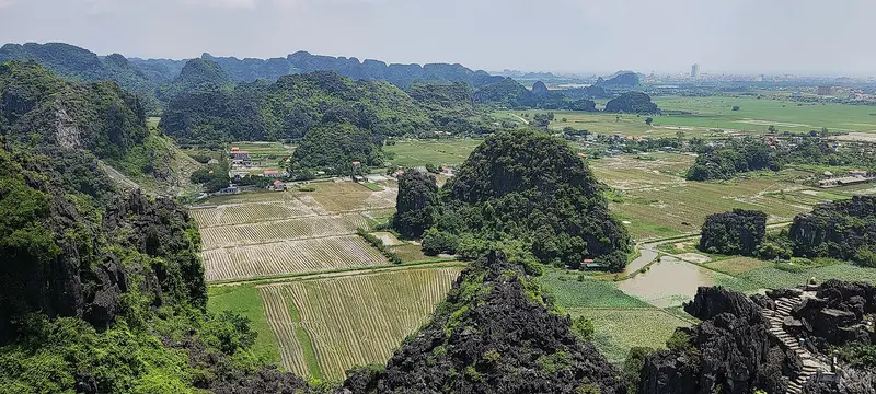
    Ninh Bình is a city in the southern Red River Delta, about two hours by bus or train south of Hanoi. You come for the surrounding karst landscape, where you travel by rowboat on rivers and through caves amidst rice paddies and limestone cliffs. The centerpiece is the Tràng An Landscape Complex, a UNESCO World Heritage Site (mixed cultural and natural) since 2014. It spans around 6,226 hectares, encompassing the ancient capital Hoa Lư, the waterways of Tràng An and Tam Cốc, and protected forests. Discoveries in the caves prove that people have lived here for over 30,000 years. From 968 to 1010, Hoa Lư was the capital of Vietnam before the court moved to Thăng Long, today's Hanoi. The city itself is primarily a transport hub. Many travellers stay overnight in Tam Cốc village, where boat docks, restaurants, and bicycle rentals are located. Good times to visit are September to November and March to May. Local specialties include goat meat from the karst slopes and Cơm cháy, deep-fried crispy rice.

    Sights in Ninh Binh

    Discover the most important sights and attractions

    Tràng An
    Attraction

    1Tràng An

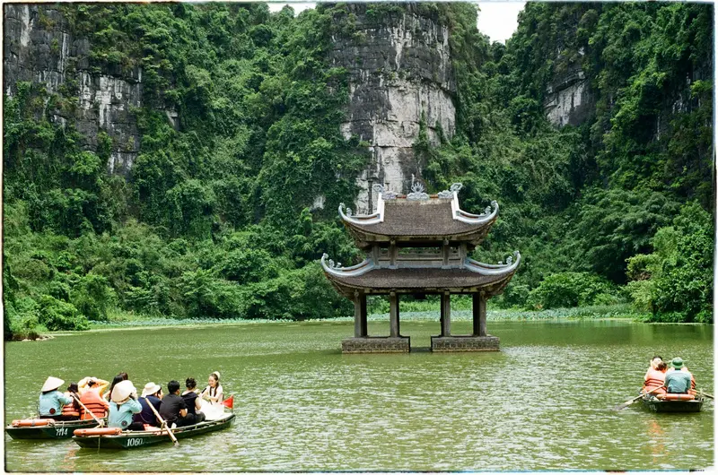
    From a pier roughly 7 km west of the city, locals row you in sampans for about three hours across rivers and through several caves amidst karst cliffs. Tràng An is the heart of the eponymous UNESCO World Heritage Site. Early in the morning, waiting times are shortest.
    Open in Google Maps
    Tam Cốc and Bích Động
    Attraction

    2Tam Cốc and Bích Động

    Tam Cốc means "three caves": The approximately 90-minute boat trip on the Ngô-Đồng River takes you through the caves Hang Cả, Hang Hai, and Hang Ba, past rice paddies and limestone karsts. Very nearby lies Bích Động, a complex built in 1428 on Ngũ Nhạc Mountain featuring three tiered temples.
    Open in Google Maps
    Ancient Capital Hoa Lư
    Attraction

    3Ancient Capital Hoa Lư

    From 968 to 1010, Hoa Lư was Vietnam's capital under the Đinh and early Lê dynasties. The roughly 300-hectare site houses temples for Đinh Tiên Hoàng and Lê Đại Hành; about half an hour is enough for a visit.
    Open in Google Maps
    Hang Múa
    Attraction

    4Hang Múa

    Around 500 steep, shadeless steps lead to a karst peak offering views over the Tam Cốc Valley and the Ngô Đồng River. The namesake cave at its foot is small, the ascent is worthwhile for the view.
    Open in Google Maps
    Bái Đính Pagoda Complex
    Attraction

    5Bái Đính Pagoda Complex

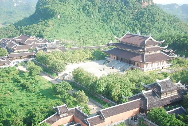
    Next to the old pagoda on Bái Đính Mountain, an extensive new temple complex was built between 2003 and 2010. A long covered walkway is lined with 500 Arhat statues, and a 36-ton bronze bell hangs in the bell tower. The complex is located about 15 kilometers north of Tam Cốc.
    Open in Google Maps

    Restaurants in Ninh Binh

    1

    Thuy Linh Restaurant

    Family restaurant in Tam Cốc village, steps from the boat pier. Specializing in local goat meat, such as steamed with ginger-lime dip or hot pot.
    Show on Google Maps

    Heritage

    Hoa Lư served as the capital from 968 to 1010 under the Đinh and early Lê Dynasties. Two temples remain: One honors Đinh Bộ Lĩnh, founder of the Đinh Dynasty, while the other, about 300 meters north, commemorates Lê Hoàn, founder of the early Lê Dynasty. In 1010, Lý Công Uẩn relocated the court to Thăng Long.The Tràng An caves preserve shell middens, stone tools, and hearths, revealing how hunter-gatherers adapted to climate and sea level fluctuations over 30,000 years.

    Getting There and Around

    Train: From Hanoi it takes about 2 hours to Ninh Bình station, which is about 7 kilometres from Tam Cốc.Bus and Car: Buses arrive at Ninh Bình bus station, from where you continue by taxi. A private car from Hanoi takes about 1.5 hours.Locally: Distances between Tam Cốc, Tràng An, Hang Múa and Hoa Lư are short, and many travellers use bicycles, motorbikes or taxis. The boat trip in Tam Cốc lasts about 90 minutes, in Tràng An around 3 hours. In Tràng An it is worth being at the pier before 9 am, as queues form later. For safety on boat trips and on the roads, see the UK FCDO Travel Advice (gov.uk/foreign-travel-advice).

    Accommodations in Ninh Binh

    Find perfect stay in Ninh Binh

    Booking.com* (Affiliate link)
    Search Hotels
    Agoda* (Affiliate link)
    Search Hotels
    Airbnb
    Vacation Rentals

    * Affiliate link: if you book through it, we earn a small commission. The price stays the same for you.

    Plan your trip to Ninh Binh

    Save places, build a route and plan your city trip, all in one place.

    1. 1
      Sunrise over alpine peaks and a sea of clouds
      1234

      Round trip

      12 days · 4 stops

      Saved

      Pick a route

      Pick a ready-made one or save places and plan your own.

      Open bookmarks
    2. 2

      Trip to Ninh Binh

      Live
      • 1Tràng An3 days
      • 2Tam Cốc and Bích Động4 days
      • 3Ancient Capital Hoa Lư5 days
      Budget

      Plan your trip

      The planner sorts stops, days and budget. Plan together in real time.

      Start trip planning
    3. 3
      9:41 No signal
      Ninh Binh
      Available offline

      Use it on the road

      Download the guide to your phone and use it on site, even offline.

    Nearby

    Hanoi

    Hanoi

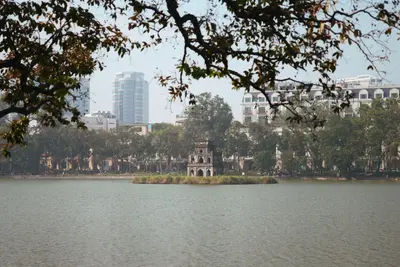
    Hanoi is the capital of Vietnam and the political and cultural center of the North, situated on the Red River. Visitors come for its over a thousand-year history, the vibrant Old Quarter around Hoàn Kiếm Lake, and the street food stalls, which are among the best in the country. In 1010, Lý Thái Tổ, the first ruler of the Lý Dynasty, made the place his capital and named it Thăng Long, "Ascending Dragon." The city has borne the name Hà Nội since 1831. From 1902, it served as the capital of French Indochina, and since 1976, it has been the capital of reunified Vietnam. Buildings from all these eras are preserved, ranging from Confucian temples to colonial villas. Key Neighborhoods Old Quarter: The dense maze of alleys north of the lake has largely preserved its historic street layout. Many streets still bear the names of the goods once traded there, such as Hàng Bạc, named after the silver shops. Most budget accommodations and street food stalls are located here. Hoàn Kiếm Lake: The lake is the heart of the city. Via the red Thê Húc Bridge, you reach Ngọc Sơn Temple on a small island; on another stands the Turtle Tower. French Quarter: South of the lake, wide avenues, colonial villas, embassies, and ministries define the area. Here you'll find the Opera House, the Hotel Metropole, and the National Museum of Vietnamese History. Ba Đình: To the west lie most of the governmental and imperial sites: the Hồ Chí Minh Mausoleum, the One Pillar Pagoda, and the Imperial Citadel of Thăng Long, a UNESCO World Heritage site since 2010. West Lake (Tây Hồ): The city's largest lake boasts approximately 17 kilometers of shoreline. On a small island near its southeastern shore stands the Trấn Quốc Pagoda, Hanoi's oldest pagoda. This district is quieter, featuring cafés, villas, and many foreign residents.
    Old Town (Phố cổ)

    Old Town (Phố cổ)

    Hanoi's Old Quarter is the dense maze of alleyways north of Hoàn Kiếm Lake, and the district where most travellers stay. Here, affordable accommodations, street food stalls, and cafés are tightly packed, and the street network has largely been preserved as it evolved over centuries.Locally, the district is known as "36 Gassen" (36 Streets), named after the guilds that once worked here. Many street names begin with "Hàng" (meaning 'goods') and still reveal what was traded there, such as Hàng Bạc after the silversmiths. Most of the narrow shop-houses with sloping tiled roofs date from the 18th and 19th centuries.In the north of the district lies Đồng Xuân Market, dating from the French colonial era, and hidden among the houses is the Bạch Mã Temple. The best way to explore the Old Quarter is on foot.
    Ba Dinh

    Ba Dinh

    Ba Đình, west of the Old Quarter, is Hanoi's political center and the district with the most imperial and revolutionary sites. It is home to the Ho Chi Minh Mausoleum, the One Pillar Pagoda, and the Imperial Citadel of Thang Long, a UNESCO World Heritage site since 2010.On today's Ba Đình Square, Ho Chi Minh read the Declaration of Independence on September 2, 1945. Wide avenues, ministries, and embassies characterize the district, which can easily be explored with a stroll from the square to the Citadel.
    West Lake (Tây Hồ)

    West Lake (Tây Hồ)

    The Tây Hồ district is located around West Lake, one of Vietnam's largest natural lakes, with approximately 17 kilometers of shoreline. It is quieter than the city center, with villas, cafés, and many Western restaurants, as a large part of Hanoi's foreign population lives here.On a small island near the southeastern shore stands the Trấn Quốc Pagoda, the city's oldest pagoda. Since 1996, the Quảng Bá flower market has taken place nightly in the district, one of the largest in the country. The lakeside is well suited for a bike ride.
    Ha Long Bay

    Ha Long Bay

    Halong Bay is a sea bay in the Gulf of Tonkin on Vietnam's northeast coast, about 170 kilometers east of Hanoi. You travel there to cruise by boat among hundreds of forested limestone karsts, visit stalactite caves, and spend a night on board on the water. Hạ Long means 'descending dragon.' According to UNESCO, the bay is considered the most extensive and well-known example of a submerged tower karst landscape worldwide. It has been a World Heritage site since 1994, and in 2023, the site was expanded to include the Cát Bà Archipelago, now encompassing 1,133 islands and islets across 65,650 hectares. To the northeast lies Bái Tử Long Bay, and to the south, Lan Hạ Bay. The starting point is Hạ Long on the bay's north shore. Excursions follow designated routes set by the bay administration, which, depending on the route, visit caves, swimming islands, kayaking areas, and pearl farms. In floating villages like Cửa Vạn, fishing families lived on boats; since 2014, many of them have been relocated to land.

    Sources & method

    • Photos: Wikimedia Commons, Unsplash, Pexels, Google Maps. Each photo carries its credit.
    • Place data such as addresses and ratings comes from Google Maps.
    • The content is based on web research from public, traceable sources. How the content is made · The role of AI