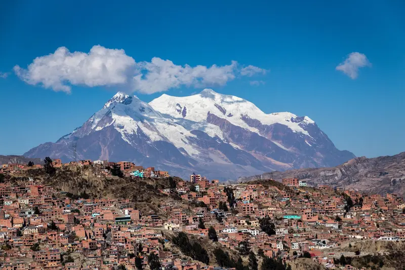
Photo by Nair Cristopher Sánchez Muñoz on Pexels
Round trip · Bolivia
Classic Bolivia: Lake Titicaca, Salar de Uyuni and Colonial Cities
by Felix Gillen
- 13 Days / 12 Nights
- La Paz → Sucre
The route connects the major destinations of the Bolivian highlands: La Paz with cable car and Tiwanaku, Lake Titicaca with Copacabana and the Isla del Sol, the Salar de Uyuni with the Lagoon Route, and finally the World Heritage cities Potosí and Sucre. All stages are traveled by bus, boat, or guided 4x4.
At a glance
- Duration
- 13 Days / 12 Nights
- Stops
- 8 · La Paz → Sucre
- Arrival
- Flight · La Paz/El Alto (LPB)
- Departure
- Flight · Sucre (SRE)
- Nights on a night train or ferry
- 1
- Best Time to Go
- May to October
8 stops
Why This Route?
It leads logically through the Highlands: Starting in La Paz and by Lake Titicaca helps with altitude acclimatization, before continuing to the 4,000m+ Lagoon Route. Then, you descend to Potosí and lower Sucre.
Hidden Gems
- Stay overnight on Isla del Sol and hike early morning before day visitors
- Feria 16 de Julio in El Alto only Thursdays and Sundays, ideally before 9 AM
- in April, with luck, mirror effect and Isla Incahuasi simultaneously
- choose the Spanish-speaking tour at Potosí's Mint House.
Getting there and back
Open jaw: start and end are in different places
- Arrival
- Flight · La Paz/El Alto (LPB)El Alto Airport is located over 4,000 m. Take a pre-ordered radio taxi into the city and plan the first few days gently. The Foreign Office offers advice on altitude.
- Departure
- Flight · Sucre (SRE)From Sucre, BoA flies to La Paz, the flight time is about 50 minutes; check the current flight schedule, international onward flights mostly go via La Paz or Santa Cruz.
Itinerary
La Paz
La Paz is Bolivia's seat of government and lies at around 3,650 m in a deep valley, above whose rim the city of El Alto spreads out at over 4,000 m. You float with the Mi Teleférico cable car over rooftops and markets, visit the Witches' Market and the colonial street Calle Jaén, and experience the enormous Feria 16 de Julio market in El Alto.The city is a starting point for excursions to Tiwanaku, Lake Titicaca, and down into the Yungas. In recent years, a young culinary scene has also developed, working with ingredients from the Andes and the Amazon.
Cable car ride to El Alto, Old Town with Calle Jaén and San Francisco, day trip to Tiwanaku (approx. 90 minutes by minibus).
7 Sights
3 Restaurants
Culture & Daily Life
Aymara City of El AltoEl Alto is shaped by Aymara culture. Striking are the Cholets by architect Freddy Mamani, dozens of colorful buildings in the "Neo-Andino" style. On Sundays, Cholita wrestling takes place in El Alto.Rituals and FestivalsAt the Mercado de las Brujas, vendors sell amulets, herbs, and offerings, and Yatiris read from coca leaves. Starting January 24, the city celebrates Alasita with miniatures for the god of fortune Ekeko, and in May or June, Gran Poder parades through the streets with thousands of dancers. Both festivals are UNESCO World Heritage sites.Young CuisineThe restaurant Gustu is considered the catalyst for the city's culinary renewal and, like Arami, is on the list of Latin America's 50 Best Restaurants.
Bus
Bus to Copacabana, about 4 to 5 hours, with a ferry across the Tiquina Strait.
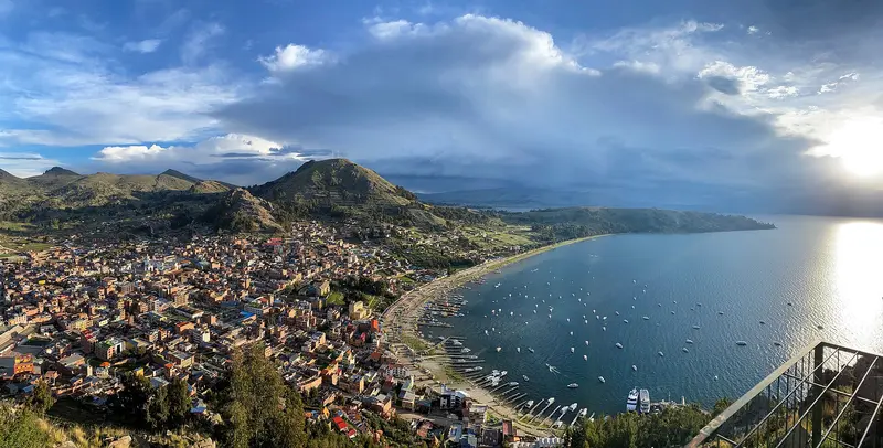
Copacabana
Copacabana, on the shores of Lake Titicaca, is Bolivia's most important Catholic pilgrimage site and the port for boats to Isla del Sol. The lake lies at about 3,810 m and is considered the highest commercially navigable lake in the world.At its heart stands the Basilica of the Virgen de Copacabana, whose figure was carved around 1576. From Cerro Calvario, you look out over the bay; in the evenings, the sun colors the lake. The town is about four to five bus hours from La Paz.
Basilica, Cerro Calvario for sunset, Horca del Inca.
3 Sights
Pilgrimage & Feasts
The Virgen de CopacabanaThe current basilica was built from 1669 to 1679. Francisco Tito Yupanqui carved the Marian figure around 1576. The main feast of the Virgen de Copacabana is on August 5; that of the Virgen de la Candelaria on February 2.Inca and AymaraAt the site stands the Horca del Inca, a stone gateway where light, through rock holes, hits the crossbeam at the solstice. On June 21, the Aymara celebrate New Year there. During Holy Week, a lantern procession climbs to Cerro Calvario.
Ferry
Boat to Yumani in about 1.5 hours, departures mostly mornings and midday.
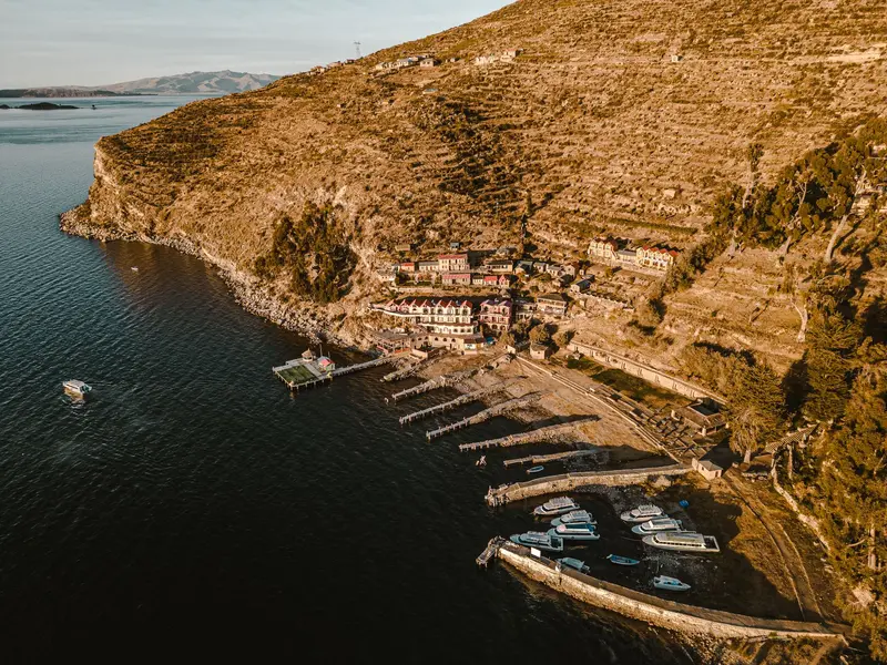
Isla del Sol
In Inca myth, Isla del Sol in Lake Titicaca is considered the origin place of the sun and moon. The island, approximately 9 by 6 km, lies about 12 km northwest of Copacabana and has three settlements: Yumani in the south, Challa in the middle, and Challapampa in the north.You ascend the steep Inca staircase from Yumani, visit the ruins of Pilkokaina, and hike ancient paths across the island. The northern part with the Chincana Labyrinth has been repeatedly closed in recent years; inquire in Copacabana about its current status.
Inca Stairs, Pilkokaina, island hike; inquire about northern access beforehand.
2 Sights
Myth and Communities
Sacred Island of the IncaAccording to Inca myth, the sun and moon ascended on the Isla del Sol. The ceremonial site Chincana in the north and the Titi Kharka rock near Challapampa belong to this legacy; on the neighboring Isla de la Luna, ruins of an Inca sanctuary stand.Communities and AdmissionThe island is administered by its communities, each collecting a small entry fee at their checkpoints. Have small bills and coins ready for this. Conflicts between the communities have repeatedly led to the closure of the northern part in recent years.
Bus · overnight
Boat back to Copacabana, bus to La Paz (4 to 5 hours), then overnight bus to Uyuni (9 to 12 hours); alternatively, flight La Paz to Uyuni in about an hour.
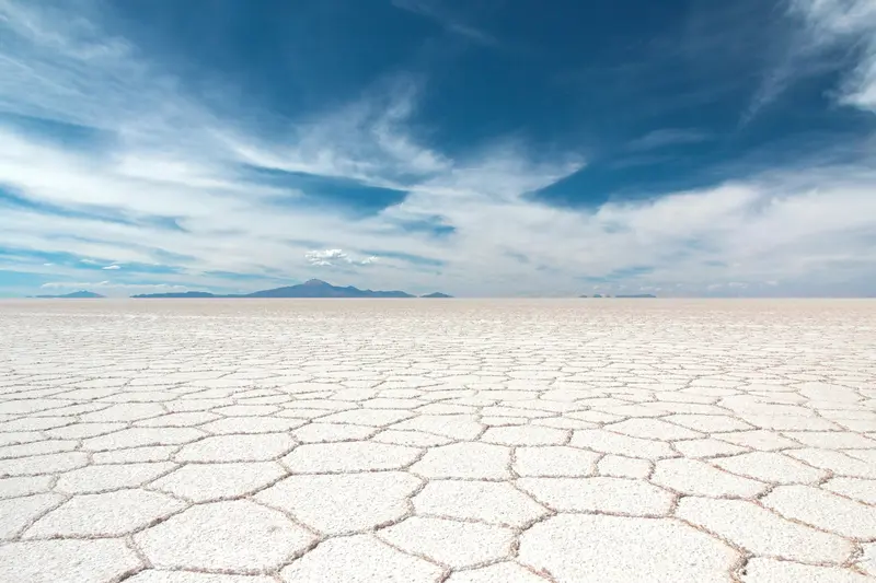
Salar de Uyuni
The Salar de Uyuni in southwestern Bolivia is a salt flat covering approximately 10,582 km² at about 3,656 meters, a white, seemingly endless surface to the horizon. It is the country's most famous travel destination and the starting point for tours to the highland lagoons.In the dry season, you drive across the hard salt crust to the cactus island Incahuasi, and in the rainy season, a thin layer of water transforms the Salar into a giant mirror. Beneath the crust lie vast lithium reserves.
4x4 tour begins in Uyuni, Train Cemetery, Colchani, Isla Incahuasi.
1 Sight
Salt and Humanity
Colchani Salt WorkersColchani, home to the Salt Workers' Cooperative, is located on the edge of the Salar. Salt is extracted and processed here, and many tours stop on their way to the salt flats.Uyuni and the RailwayThe city of Uyuni, at around 3,700 m, is the region's tourist hub. About 3 km outside, old steam locomotives and wagons rust at the Cementerio de Trenes, a testament to the highlands' railway history.
Car
Continue with the guided off-road vehicle tour to the south
Eduardo Avaroa Reserve
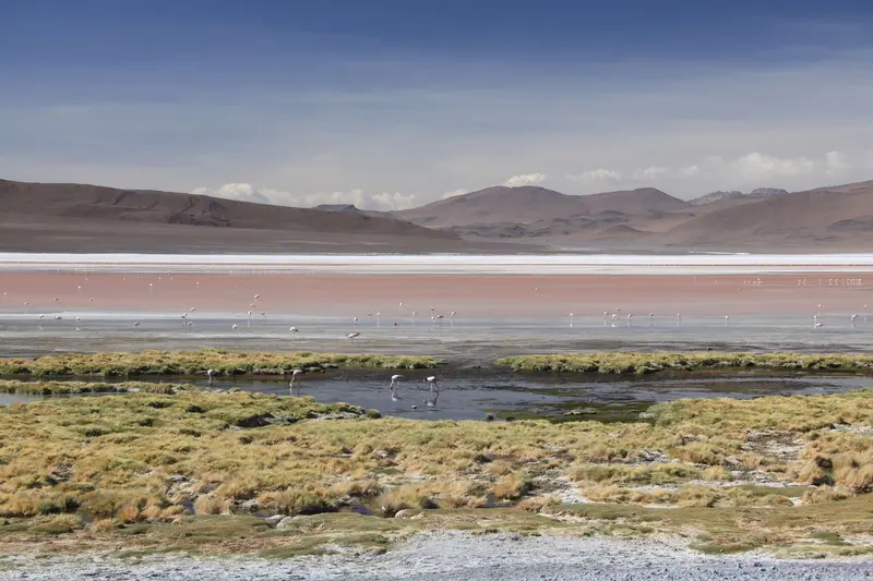
The Reserva Nacional de Fauna Andina Eduardo Avaroa, in Bolivia's far southwest bordering Chile, covers approx. 7,150 km² of highland with colorful lagoons, volcanoes, and geysers. On the multi-day Lagoon Route from Uyuni, you'll experience some of the most impressive landscapes of the Andes.The reddish Laguna Colorada, at around 4,278 m, is home to flamingos, with three species found in the protected area. Further south, the Sol de Mañana geyser field steams at almost 5,000 m, and at Termas de Polques, you can bathe in thermal water around 29°C.
Laguna Colorada, Sol de Mañana Geyser Field, Termas de Polques, Laguna Verde. Bring cash for admission.
2 Sights
Sanctuary and Wildlife
A Highland ReserveThe protected area was founded in 1973 and has been part of the Ramsar wetland Los Lípez since 2009. Andean, James, and Chilean flamingos live here.LandscapeThe area is mostly located between approximately 4,200 and 5,400 m. Along the way, you'll pass rock formations like the Árbol de Piedra, a stone shaped by the wind.
Car
Tour's return trip to Uyuni
Uyuni
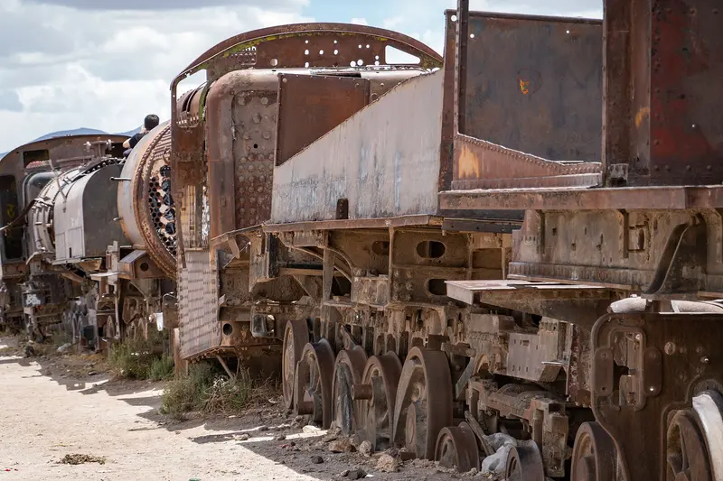
The small town of Uyuni, at around 3,700 m in the Potosí Department, is the starting point for tours to the Salar de Uyuni and along the Lagoon Route south. This is where 4x4s depart, and where planes, night buses, and trains from the north arrive.On the town's edge, old steam locomotives and wagons rust at the Train Cemetery. By the Salar, Colchani's salt workers process their salt. The Foreign Office lists Uyuni among locations needing increased caution due to crime.
Rest day after the tour.
2 Sights
Railroad and Salt
Train CemeteryAbout 3 km outside the city, disused steam locomotives and wagons rust, a popular photo spot at the beginning or end of Salar tours.Salt WorkersIn Colchani, on the edge of the Salar, is the salt workers' cooperative, who extract and process salt here.
Bus
Bus to Potosí in about 4 hours (204 km)
Potosí
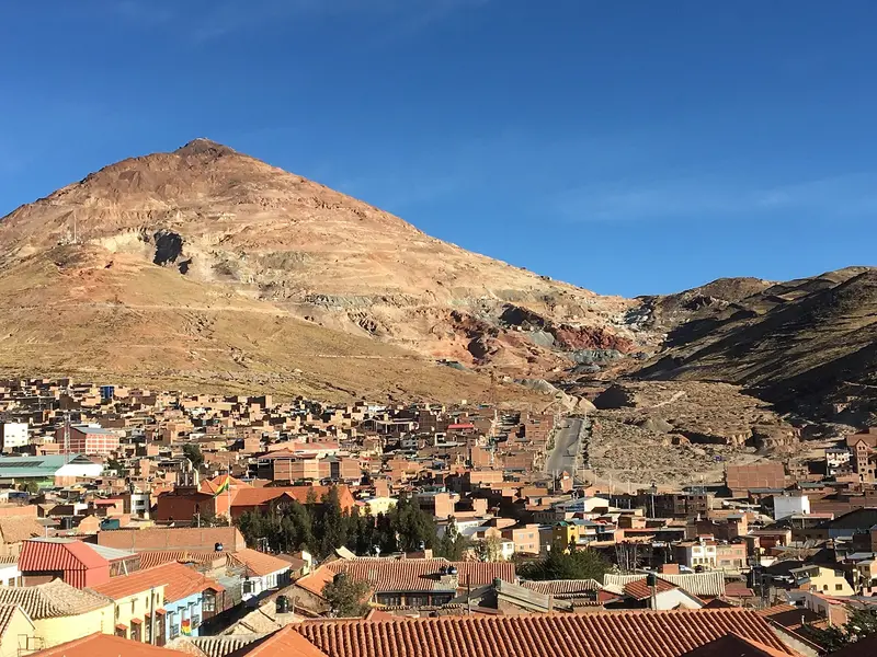
Potosí is located at approximately 4,000 m (13,000 ft) at the foot of Cerro Rico, the Silver Mountain, which made the city one of the world's largest industrial centers from 1545. Its old town has been a UNESCO World Heritage site since 1987 and on the Red List of Endangered World Heritage since 2014.At the Casa Nacional de Moneda, you'll see how silver was turned into coins, and in the alleys, churches and colonial buildings from its heyday. Potosí is central to understanding South America's colonial history, and is three to four bus hours from Sucre.
Tour of the Casa Nacional de Moneda, views of Cerro Rico.
2 Sights
Silvertown
The Cerro RicoSilver mining began on Cerro Rico in 1545. UNESCO describes Potosí as the largest industrial complex of the 16th century, with 22 reservoirs, 140 mills, and the mercury process. Due to mining, the mountain is now porous and unstable; parts of the summit have collapsed.Colonial HeritageBesides the Mint House, the World Heritage site includes the Church of San Lorenzo, the Mita workers' quarters, and the watermills (ingenios). Due to uncontrolled mining, the city has been on the Red List since 2014.Ch'utillosAround August 24, Potosí celebrates Ch'utillos in honor of San Bartolomé, a UNESCO cultural heritage since 2023.
Bus
Bus to Sucre in about 3 to 4 hours
Sucre
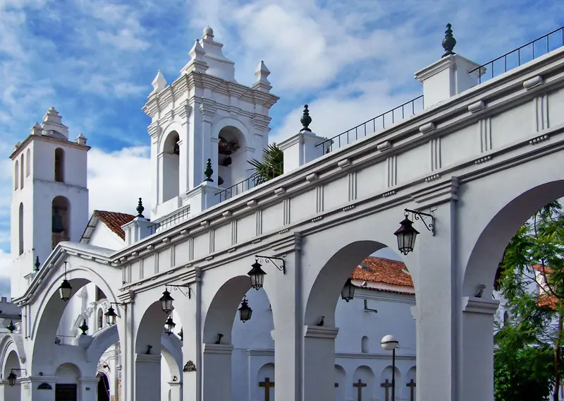
Sucre is Bolivia's constitutional capital, a whitewashed colonial city located at around 2,790 m. Its old town has been a UNESCO World Heritage site since 1991, where the country's independence was declared on August 6, 1825.You visit the Casa de la Libertad, 16th-century churches, and the rooftop terraces of San Felipe Neri, take in views of the city from La Recoleta, and on the outskirts, see thousands of dinosaur footprints on a rock face. On Sundays, a trip to Tarabuco Market is worthwhile.
Old Town, Recoleta, Cal Orck'o dinosaur tracks; Sundays, excursion to Tarabuco Market (approx. 1.5 hours).
4 Sights
3 Restaurants
History and Artisanship
City of IndependenceSucre was founded in 1538 as Ciudad de la Plata de la Nueva Toledo. UNESCO highlights the blend of local building traditions with European styles from the 16th to 19th centuries. The Act of Independence from 1825 is housed in the Casa de la Libertad, a former Jesuit building.Regional Textile ArtThe region is known for the weaving art of the Jalq'a and Tarabuco peoples, showcased in seven halls at the Museo de Arte Indígena ASUR. In Tarabuco, the Pujllay festival is celebrated on the third Sunday in March, recognized by UNESCO as intangible heritage.CuisineTypical Sucre dishes include Chorizo chuquisaqueño and Salteñas in the morning, and Mondongo for lunch.
Plan this route as your trip
All stops, trains and nights go into your trip planner. You adjust dates and places to stay afterwards.
This route is a suggestion from our research. Please check timetables, times in port, opening hours and prices before you book – what your tour operator or carrier says is what counts.
Fernweh is a free travel guide and trip planner: routes researched by people, taken over in one click, used day by day on the road. More about Fernweh
8 stops
Route Summary
Duration13 Days
Stops8 Places
TypeMixed