Fernweh: Home
    ExploreTravel GuidesPlan a tripMy tripLast visited
    de|en
    All Places & RegionsAll highlightsAbout FernwehFAQPrivacy PolicyImprint
    ExploreTravel GuidesPlan a tripMy tripLast visited
    Purnululu National Park

    Australia

    Purnululu National Park

    National ParkNature

    Purnululu National Park, located in the east of the Kimberley, protects the Bungle Bungle Range, a field of striped sandstone domes that only became known outside the region in 1983.

    by Felix Gillen

    1. Home
    2. Destinations
    3. Australia
    4. Kimberley
    5. Purnululu National Park
    Purnululu National Park, located in the east of the Kimberley, protects the Bungle Bungle Range, a field of striped sandstone domes that only became known outside the region in 1983. Since 2003, the park has been a UNESCO World Heritage site.Access is via a 53 km long 4WD track; the park is only open during the dry season. Many visitors therefore arrive by scenic flight from Kununurra.

    Sehenswürdigkeiten

    Discover the most important sights and attractions

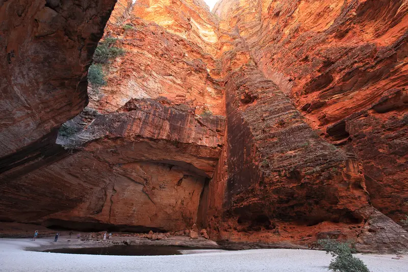
    Cathedral Gorge

    1Cathedral Gorge

    A path of approx. 2 km round trip leads through a streambed into a circular amphitheater of overhanging rock walls with a seasonal water pool. It's the most famous hike in the south of the park and most beautiful in the early morning.
    Open in Google Maps

    2Kungkalanayi Lookout

    Lookout hill in the south of the park with views over the domes of the Bungle Bungle Range. The short climb is especially worthwhile at sunset, when the stripes glow in orange and black.
    Open in Google Maps
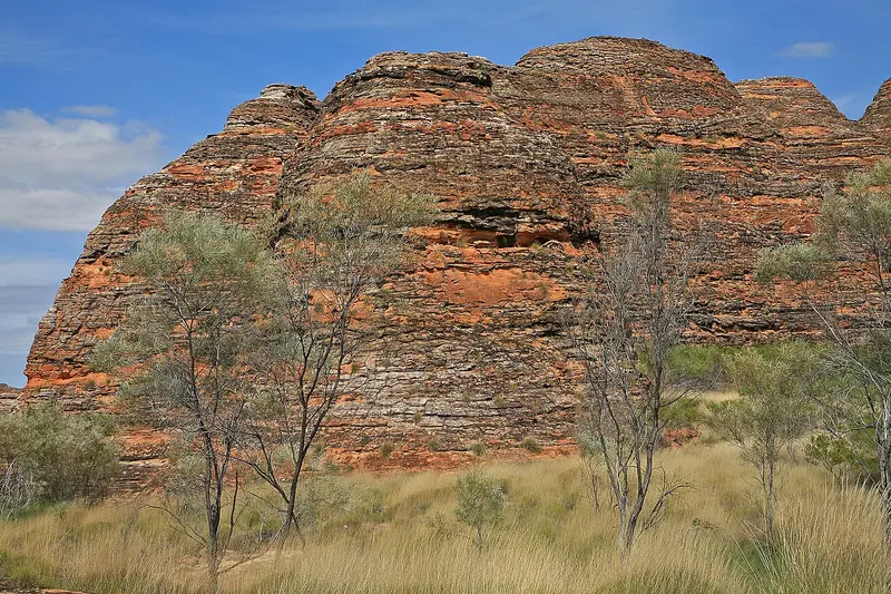
    The Bungle Bungles

    3The Bungle Bungles

    The Bungle Bungle Range consists of hundreds of beehive-shaped sandstone domes with orange and black stripes. You get closest to them on the short Domes Walk in the south, but the full extent is best seen from the air.
    Open in Google Maps

    Restaurants in Purnululu National Park

    Culture & Character

    Discovered Late, Long KnownThe Bungle Bungle Range's striped sandstone domes became known to the outside world only in 1983 – one of Earth's last great landscape finds. To the Kija and Jaru, this land was never unknown: they've resided here for millennia, linking domes, gorges, and waterholes to creation stories. Purnululu is the Kija word for sandstone. The national park was established in 1987; it achieved World Heritage status in 2003.How the Stripes FormThe orange bands derive from iron and manganese compounds in the rock; the dark ones from cyanobacteria, retaining surface moisture. Both layers alternate because the sandstone was deposited with varying densities. The formation is approximately 350 million years old, its current shape a result of millions of years of erosion. Guided tours with Indigenous guides provide cultural context for the area.

    Arrival & Orientation

    Getting ThereThe park is located in the East Kimberley, approximately 300 kilometres south of Kununurra. From the Great Northern Highway, Spur Creek Road branches off: a 53-kilometre unsealed track with several creek crossings, requiring a 4WD vehicle and taking two and a half hours each way. Caravans and trailers are not permitted on this route.SeasonThe park is only open during the dry season, typically from April to October. During the wet season, the access road is flooded, and the park remains completely closed. Inside the park, the northern and southern loop roads are about an hour's drive apart – plan to visit both on separate days or with an early start. There are no supplies available: you must bring your own water, fuel, and food.

    Accommodations in Purnululu National Park

    Find perfect stay in Purnululu National Park

    Booking.com* (Affiliate link)
    Search Hotels
    Agoda* (Affiliate link)
    Search Hotels
    Airbnb
    Vacation Rentals

    * Affiliate link: if you book through it, we earn a small commission. The price stays the same for you.

    Nearby

    Kununurra

    Kununurra

    Kununurra, in the east of the Kimberley, was established in the 1960s as the heart of the Ord River Irrigation Scheme. Today, approximately 5,000 people reside here, surrounded by irrigated fields of mangos, melons, and sandalwood, Lake Kununurra, and the red rocks of Mirima National Park.The town is a starting point for Lake Argyle, the Bungle Bungles, and the eastern end of the Gibb River Road.
    Kimberley

    Kimberley

    At roughly 420,000 km², the Kimberley in northern Western Australia is larger than Germany, yet home to only about 40,000 inhabitants. Gorges, waterfalls, the Bungle Bungles' beehive domes, and a rugged coast with extreme tides define the region.Most travellers start in Broome in the west or Kununurra in the east. Between these, the Gibb River Road leads through the outback.
    Darwin

    Darwin

    Darwin is the tropical capital of the Northern Territory and the gateway to Kakadu and Litchfield. A relaxed coastal town with night markets, sunsets, and rich war history.
    Broome

    Broome

    Broome on Roebuck Bay, with 14,000 residents, is the Kimberley's largest town and western gateway. The town grew from pearl fishing; Chinatown, with tin buildings, pearl shops, and the Sun Pictures open-air cinema, tells the story.Cable Beach, red cliffs at Gantheaume Point, and a tidal range of up to 10 m characterize the surroundings. The dry season, May to October, is high season.
    Kakadu National Park

    Kakadu National Park

    Kakadu National Park in the north of the Northern Territory is Australia's largest national park, spanning nearly 20,000 km². It stretches from tidal rivers on the coast across vast wetlands to the Arnhem Plateau escarpment with its waterfalls.The park is listed as a natural and cultural heritage site on the UNESCO World Heritage List. The Bininj/Mungguy have lived here for at least 65,000 years, and their rock art at Ubirr and Burrunggui is among the most significant in the world.

    Sources & method

    • Photos: Wikimedia Commons, Unsplash. Each photo carries its credit.
    • Place data such as addresses and ratings comes from Google Maps.
    • The content is based on web research from public, traceable sources. How the content is made · The role of AI