Fernweh: Home
ExploreGuideDestinationsMy tripsMy trip
de|en
All Places & RegionsRound tripsNight trains in EuropeAll highlightsAbout FernwehFAQPrivacy PolicyImprint
Download on the App StoreGet it on Google Play
ExploreGuideDestinationsMy tripsMy trip
    • Neighborhoods & highlights
    • Eat & drink
    • Culture
    • Getting around
    • Accommodation
    • Plan trip
    • Nearby
    Kalamata

    Photo by John K on Pexels

    Greece

    Kalamata

    CityCultureBeach

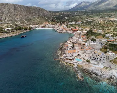
    Kalamata, Peloponnese's second-largest city after Patras, sits on the Messenian Gulf below the Taygetus Mountains. On March 23, 1821, Greek rebels captured the city, making it the first liberated city of the War of Independence.

    by Felix Gillen

    1. Home
    2. Destinations
    3. Greece
    4. Peloponnese
    5. Kalamata
    Kalamata, Peloponnese's second-largest city after Patras, sits on the Messenian Gulf below the Taygetus Mountains. On March 23, 1821, Greek rebels captured the city, making it the first liberated city of the War of Independence. Known for its olives and olive oil. With its own airport, it's a great base for ancient Messene, Mani, and the Bay of Navarino near Pylos.
    Greece travel guideRound trips in GreecePlan a trip with Kalamata

    Contents

    • Neighborhoods & highlights
    • Eat & drink
    • Culture
    • Getting around
    • Accommodation
    • Nearby

    Sights in Kalamata

    Discover the most important sights and attractions

    Castle

    1Castle of Kalamata

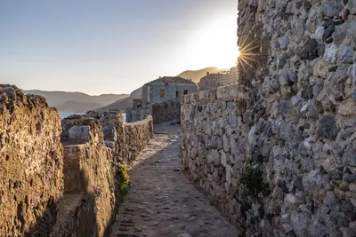
    The castle sits on a low hill north of the city above the Nedon River, on the site of the acropolis of ancient Pharai. The Franks conquered the Byzantine fortress in 1205; under the Villehardouin family, it received its current form in the 13th century, and later the Venetians and Ottomans expanded it. From the walls, you look out over the roofs of the Old Town to the Messenian Gulf. At the foot of the hill lie the Ypapanti Cathedral, consecrated in 1873, and the Kalograion Monastery from 1796, whose nuns were known for their silk scarves.

    Open in Google Maps
    Church

    2Church of the Holy Apostles and Old Town

    The small Byzantine Church of the Holy Apostles (Agioi Apostoloi) dates back to the 11th and 12th centuries and is the city's landmark: It was here that Petrobey Mavromichalis declared the uprising against the Ottomans in 1821. It stands on March 23rd Square, named after the city's liberation day. Surrounding it is the Paplomatadika district, the old town's liveliest part, featuring pedestrian lanes, old shops, ouzerias, and cafés.
    Open in Google Maps
    Park

    3Municipal Railway Park

    The park on Aristomenous Street has been an open-air railway museum since 1986, centered around the building of a former train station. Among fountains, small ponds, and playgrounds, several steam locomotives are on display, including tank locomotives from the Athens–Peloponnese line and a German war locomotive, alongside historic passenger and freight cars. The old station building features a snack bar. Situated halfway between the old town and the sea, the park makes for an excellent stop with children.
    Open in Google Maps

    Restaurants in Kalamata

    1

    Foino

    Restaurant on Ypapantis Street in the Old Town featuring traditional and modern dishes inspired by Messenian cuisine and an extensive wine list.
    Show on Google Maps
    2

    Oinopantopoleion Chrysomalli

    Traditional wine shop with a tavern in the Old Town, serving modern Greek dishes such as Bifteki or ravioli with Manouri cheese.
    Show on Google Maps
    3

    Thiasos

    Kafeneio and Ouzeri on Ypapantis Street, known for Meze and slow-cooked suckling pig (Gourounopoula), a specialty of the area.
    Show on Google Maps
    4

    Taverna Vagias

    Long-standing family tavern east of the center with homemade traditional cuisine, such as vegetables stewed in olive oil (Ladera) and cured pork.
    Show on Google Maps

    Culture and Taste

    Olives and OilKalamata is renowned for its dark olives and olive oil, both exported from here. At the market next to the bus station, you can buy them directly from the producers.Dance and HistoryThe folk dance Kalamatianos is named after the city. Every July, the International Dance Festival takes place; one venue is the Dance Hall, which opened in 2013. In the Church of the Holy Apostles, the city commemorates the beginning of the 1821 Uprising.

    Getting There and About

    Getting ThereKalamata Airport is located about 10 kilometers west of the city and offers direct flights from Central Europe in summer. By car, it's approximately 240 kilometers and about two and a half hours from Athens via the motorway. KTEL buses depart from Kifissos Bus Station in Athens, reaching Kalamata in three to four hours. The bus station is located next to the market hall near the Old Town.Getting AroundYou can explore the Old Town on foot, while city buses shuttle between the center and the beach. For excursions to Messene, the Mani, or Pylos, a rental car is practical; agencies are available at the airport and in the city. The road to the Mani leads via Kardamyli (about 36 kilometers) to Stoupa.

    Accommodations in Kalamata

    Find perfect stay in Kalamata

    Booking.com* (Affiliate link)
    Search Hotels
    Agoda* (Affiliate link)
    Search Hotels
    Airbnb
    Vacation Rentals

    * Affiliate link: if you book through it, we earn a small commission. The price stays the same for you.

    Campgrounds in Kalamata

    Find perfect campground in Kalamata

    Search via Google Maps
    Campgrounds nearby (15km)
    Camping.info
    Find Campgrounds
    Park4Night
    RV Parks & Camping

    Plan your trip to Kalamata

    Save places, build a route and plan your city trip, all in one place.

    1. 1
      Sunrise over alpine peaks and a sea of clouds
      1234

      Round trip

      12 days · 4 stops

      Saved

      Pick a route

      Pick a ready-made one or save places and plan your own.

      Open bookmarks
    2. 2

      Trip to Kalamata

      Live
      • 1Castle of Kalamata3 days
      • 2Church of the Holy Apostles and Old Town4 days
      • 3Municipal Railway Park5 days
      Budget

      Plan your trip

      The planner sorts stops, days and budget. Plan together in real time.

      Start trip planning
    3. 3
      9:41 No signal
      Kalamata
      Available offline

      Photo by John K on Pexels

      Use it on the road

      Download the guide to your phone and use it on site, even offline.

    Nearby

    Mani

    Mani

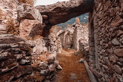
    The Mani is the middle of the three southern fingers of the Peloponnese, a barren limestone landscape between the Taygetos and the sea. Residential towers of grey rubble stone characterize the villages from Kardamyli down to Cape Tenaro, the southernmost point of the Greek mainland. Between them lie bays with clear water, Byzantine chapels, and the caves of Diros.

    C messier·CC BY-SA 4.0

    Peloponnese

    Peloponnese

    The Peloponnese hangs off the southern end of the Greek mainland and, strictly speaking, is an island since the construction of the Corinth Canal. Mycenaean castles, the Sanctuary of Olympia, Byzantine ruined cities, and Venetian sea fortresses lie close together here.Between them, mountain ranges rise to over 2,400 meters, with Taygetos reaching 2,407 meters. The coastal roads remain narrow and winding; those who travel the peninsula are better off planning with few base locations and day trips.

    Unsplash

    Ancient Olympia

    Ancient Olympia

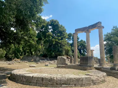
    Ancient Olympia is located in the region of Elis in the west of the Peloponnese, where the Kladeos flows into the Alpheios. From 776 BC to 393 AD, the Olympic Games were held here every four years in honor of Zeus, for almost twelve centuries. Of the sanctuary, foundations, toppled column drums, and the stadium are preserved; the sculptures are in the museum opposite.

    Lydia Griva·Pexels

    Nafplio

    Nafplio

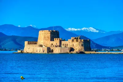
    Nafplio lies on Argolis' east coast, on the Argolian Gulf, some 140 kilometers southwest of Athens. From 1823 to 1834, it served as the first capital of independent Greece, having previously seen Venetians and Ottomans alternately rule its port. The city retains three fortresses, a compact old town of Venetian and neoclassical houses, and a scenic rock path encircling the peninsula.

    Alex Ravvas·Pexels

    Monemvasia

    Monemvasia

    Monemvasia is perched on a steep limestone rock off the Laconian east coast, linked to the mainland solely by a causeway. Its name, meaning 'single entrance', accurately describes this location, which made the settlement difficult to attack since its 6th-century founding.Behind the walls, Byzantine churches and stone houses stand closely together; above on the plateau lies the deserted Upper Town with the Church of Agia Sofia. The town is car-free and ideal for one or two peaceful days.

    Unsplash

    Your next steps

    Kalamata is in Greece. Ways to carry on from here.

    • More in Greece

      Highlights, areas, routes and the best time to travel for all of Greece.

      Greece travel guide
    • Round trips in Greece

      Ready-made routes through Greece, with stops, nights and a map.

      See the routes

    Sources & method

    • Photos: Pexels. Each photo carries its credit.
    • Place data such as addresses and ratings comes from Google Maps.
    • The content is based on web research from public, traceable sources. How the content is made · The role of AI