Australia
Red Centre
Region
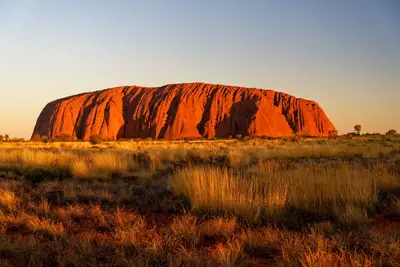
The Red Centre, a desert region in the south of the Northern Territory, encompasses Alice Springs, Uluru, Kata Tjuta, and Kings Canyon. Red sand plains, rocky gorges, and waterholes in the MacDonnell Ranges define its landscape.
by Felix Gillen
The Red Centre, a desert region in the south of the Northern Territory, encompasses Alice Springs, Uluru, Kata Tjuta, and Kings Canyon. Red sand plains, rocky gorges, and waterholes in the MacDonnell Ranges define its landscape.For tens of thousands of years, the region has been home to the Arrernte, Anangu, and Luritja. Their culture is evident daily, in art centres, guided walks, and the rules at sacred sites.
The Red Centre is the geographical heart of Australia, characterized by ancient, ochre-colored landscapes and the deeply rooted culture of the indigenous Anangu people.Key attractions include the monolithic Uluru and the nearby rock formations of Kata Tjuta, both sacred sites with rich spiritual significance.You can explore these monuments on walking trails and learn more about the fascinating Dreamtime stories.Another highlight is Kings Canyon in Watarrka National Park, whose steep cliffs and lush oases invite extensive exploration.The city of Alice Springs serves as a regional base and offers insights into local Aboriginal art and history.For an optimal travel experience, the dry season from May to September is recommended; always ensure adequate sun protection and hydration.


Essen & Trinken
Thai-Indian cuisine at the DoubleTree by Hilton in Alice Springs, one of the city's most renowned addresses for dinner.
Buffet restaurant at the Hotel Sails in the Desert in the Ayers Rock Resort, featuring Australian dishes and local ingredients.
Grill restaurant at Kings Canyon Resort, one of the few dining options between Uluru and the West MacDonnell Ranges.
Food and Drink
The selection focuses on Alice Springs and the resort in Yulara. Outside of these, Roadhouses are the only dining options, serving burgers, pies, and simple dishes.
Bush Tucker
Wild plants and fruits like Quandong, Wattleseed, or Bushtomato appear on menus and during guided tours, where Aboriginal guides explain their uses.
Kangaroo and Camel
Kangaroo meat is lean and can be found on many menus in Alice Springs. Camel is also occasionally served, as the animals live wild in the Outback.
Dinner under the starry sky
In Yulara, outdoor dinners in the dunes overlooking Uluru are offered. They are expensive and should be booked early.
Best Time to Visit
When is the best time for your trip?
12–20°C·8–18 mm(little rain)
From April to September, days are warm and dry, ideal for hiking. On winter nights from June to August, temperatures often drop below zero degrees. From November to March, daytime temperatures regularly rise above 35 °C, then hiking trails are closed at midday.
Readings for Alice Springs are similar at Uluru. Day-night temperature differences are significant in the desert.
Seasons
Jan
Feb
Mar
Apr
May
Jun
Jul
Aug
Sep
Oct
Nov
Dec
Peak season: mild and dry
Changeover: warm
Summer: very hot, occasional thunderstorms
Best Time to Visit
▶Show detailed monthly data
| Month | Temp (°C) | Rain (mm) |
|---|---|---|
| January | 29.0 | 40 |
| February | 28.0 | 44 |
| March | 25.0 | 32 |
| April | 20.0 | 18 |
| May | 16.0 | 18 |
| June | 12.0 | 13 |
| July | 12.0 | 13 |
| August | 14.0 | 9 |
| September | 19.0 | 8 |
| October | 23.0 | 21 |
| November | 26.0 | 29 |
| December | 28.0 | 38 |
Culture & History
Land of the Anangu and ArrernteUluru and Kata Tjuta are sacred places for the Anangu, linked to the stories of Tjukurpa, the law and knowledge of their ancestors. In 1985, the land was returned to the Traditional Owners, and since then, they have managed the National Park jointly with Parks Australia. Since October 2019, climbing Uluru has been prohibited. Photography is also forbidden in several areas, which are signposted on-site.Alice Springs, Mparntwe in Arrernte, is the cultural heart of the region. Galleries and art centers such as Araluen or Tjanpi Desert Weavers showcase contemporary Aboriginal art from surrounding communities, often directly from the artists.Pioneer HistoryThe telegraph station from 1872 was part of the overland telegraph line from Adelaide to Darwin and the origin of Alice Springs. From this era also stem the Royal Flying Doctor Service and the School of the Air, which still teaches children on remote farms today.
Exploring the Red Centre
The distances are considerable: From Alice Springs to Yulara, the resort town near Uluru, it's about 450 km. From Yulara to Kings Canyon, expect around 300 km. The main routes, the Stuart and Lasseter Highways, are asphalted and navigable with a standard rental car.Flight: Alice Springs and Ayers Rock Airport (near Yulara) are served by flights from several major cities. Many travelers opt to fly into one airport and out of the other.Rental Car: The most flexible option. Fuel up at every opportunity, as petrol stations can be over 100 km apart in places.Mereenie Loop: This unsealed connection between the West MacDonnell Ranges and Kings Canyon requires a 4WD vehicle and a permit.Avoid Night Driving: Kangaroos, cattle, and camels on the road pose the greatest accident risk after sunset.Uluru-Kata Tjuta Park Entry: 38 AUD per adult for three days; under 18s free.