Fernweh: Home
    ExploreTravel GuidesPlan a tripMy tripLast visited
    de|en
    All Places & RegionsAll highlightsAbout FernwehFAQPrivacy PolicyImprint
    ExploreTravel GuidesPlan a tripMy tripLast visited
    • Neighborhoods & highlights
    • Recommendations
    • Walking tours
    • Eat & drink
    • Food culture
    • Culture
    • Nightlife
    • Getting around
    • Accommodation
    • Plan trip
    • Nearby
    Guanajuato

    Mexico

    Guanajuato

    CityCulture

    Guanajuato stretches at over 2,000 m altitude through a narrow gorge in the central highlands, approximately 340 road kilometers northwest of Mexico City.

    by Felix Gillen

    1. Home
    2. Destinations
    3. Mexico
    4. Central Mexican Highlands
    5. Guanajuato
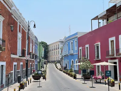
    Guanajuato stretches at over 2,000 m altitude through a narrow gorge in the central highlands, approximately 340 road kilometers northwest of Mexico City. You come for the colorful Old Town from the silver mining era, a UNESCO World Heritage site since 1988, with steep stair-alleys, Baroque churches, and squares bustling with students. In the 18th century, the La Valenciana mine at times supplied around two-thirds of the world's silver production, making the city rich. Colorful houses cling to the slopes, and most traffic runs through tunnels beneath the Old Town.
    Barrio de la Presa

    District 1 of 2

    Barrio de la Presa

    La Presa lies southeast of the Old Town, along the Paseo de la Presa, leading up to the Presa de la Olla reservoir.

    Discover
    Barrio de Pastita

    District 2 of 2

    Barrio de Pastita

    Pastita is a residential district on the eastern edge of Guanajuato, traversed by an old aqueduct. Tourists rarely venture here, but you'll witness everyday life amidst colorful houses, small tiendas, and stepped alleys.

    Discover

    Sights in Guanajuato

    Discover the most important sights and attractions

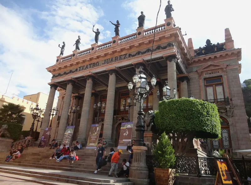
    Teatro Juárez

    1Teatro Juárez

    Theater at Jardín de la Unión, opened in 1903. The neoclassical facade with columns and bronze figures of the Muses dominates the square; inside, Moorish-inspired opulence reigns. Tours daily; in October, it is the main venue for the Festival Cervantino.
    Open in Google Maps

    2Collegiate Basilica

    Yellow Baroque basilica on the Plaza de la Paz. Inside is the wooden Marian figure Nuestra Señora de Guanajuato, which Karl V. and his son Philipp II. gifted to the city in 1557.
    Open in Google Maps

    3Museo Palacio de los Poderes

    Former seat of the state parliament and judiciary, inaugurated 1903 with a neoclassical facade. Since 2017, a state history museum; highlight is the old plenary hall with crystal chandeliers.
    Open in Google Maps

    4Monumento al Pípila

    Stone statue on the hill overlooking the city. It honors the miner El Pípila, who in 1810, during the War of Independence, set the Alhóndiga's gate ablaze. The terrace offers the best view of the colorful city. Up by funicular or on foot.
    Open in Google Maps

    5Alhóndiga de Granaditas

    Former granary, location of the first major Independence War battle in 1810. From 1811-1821, the heads of insurgents Hidalgo, Allende, Aldama, and Jiménez hung in cages at the building's corners. Since 1958, it houses the Guanajuato Regional Museum.
    Open in Google Maps

    6Museo Ex Hacienda San Gabriel de Barrera

    The former Hacienda de Barrera Grande is located on the road to Marfil, approximately two and a half kilometers west of the center. Across approximately 22,000 square meters, 17 gardens are laid out in their own distinct styles; a museum is housed in the main building.
    Open in Google Maps

    City walks in Guanajuato

    Curated walking tours through the city's highlights, handpicked by experienced travel journalists.

    Guanajuato's Underworld: Tunnels, Legends and Mummies

    Immerse yourself in the hidden sides of Guanajuato. This walk takes you through the fascinating labyrinth of underground streets, tells of dark legends and reveals the unique story of the world-famous Mummies of Guanajuato. A journey of discovery away from the colourful squares that looks deep into the soul of the city.

    ~2 Std.
    Open in Google Maps
    Stops (6)

    Essen & Trinken

    1

    Macaria Mezcaleria & Cocina

    Mezcalería with cuisine downtown. Wide selection of Mezcal from various states, alongside Mexican dishes.
    Show on Google Maps
    2

    Bar Tradicional Luna

    Bar and restaurant of the eponymous hotel at Jardín de la Unión 10, with outdoor tables overlooking the square. Popular until late in the evening, it's a spot for food and drinks with a view of the lively activity in the Jardín.
    Show on Google Maps
    3

    La Tasca De La Paz Guanajuato

    Restaurant at Plaza de la Paz 28 near the Basílica Colegiata with Mexican and Spanish dishes, also for breakfast.
    Show on Google Maps
    4

    Casa Valadez

    Traditional restaurant on Jardín de la Unión, opposite Teatro Juárez. Mexican and international cuisine, from breakfast to dinner. Window seats facing the square are popular.
    Show on Google Maps
    5

    Mestizo

    Small restaurant on Calle Positos offering contemporary Mexican cuisine. The menu changes, and portions are carefully presented. Reserve in the evening.
    Show on Google Maps
    6

    Truco 7

    Cafe & restaurant in a Basilica-side alley, a student favorite. Affordable daily menus, breakfast, and coffee in rooms with vintage decor and art.
    Show on Google Maps
    7

    La Clave Azul

    A tavern in a callejón above the city center, packed with curios and sacred images. Beer and Mezcal are served with Botanas, small snacks accompanying the drinks.
    Show on Google Maps
    8

    Casa Mercedes

    Restaurant on Calle de Arriba above the city center, access via the Panorámica. Upscale Mexican cuisine with city views, reserve in the evening.
    Show on Google Maps

    Food and Drink

    Bajío cuisine is hearty and cheap. You'll eat well for little at Mercado Hidalgo and university fondas.

    Enchiladas mineras

    Tortillas in Guajillo sauce with potatoes and carrots, filled with cheese. The miners' dish.

    Guacamaya

    Bread with Chicharrón, avocado and spicy salsa, a snack from León.

    Charamuscas

    Twisted caramel figures, often shaped like mummies, in the city's sweet shops.

    History and Culture

    Silver and IndependenceSilver veins were mined here starting in 1548, and Santa Fe de Guanajuato was officially founded in 1570. In the 18th century, the La Valenciana mine at times supplied about two-thirds of the world's silver. In 1810, insurgents led by Miguel Hidalgo stormed the Alhóndiga de Granaditas, marking one of the first battles of the War of Independence.Festival CervantinoEvolving from performances of Cervantes' interludes in small squares, the Festival Internacional Cervantino was established in 1972, becoming one of Latin America's largest cultural festivals. Every October, theater, music, and dance from around the world converge. In 2026, its 54th edition took place from October 3rd to 18th, with France as the guest country.ExcursionsWorthwhile excursions include the old La Valenciana silver mine with its Baroque San Cayetano church, the Cerro del Cubilete with the Cristo Rey statue of Christ, and Dolores Hidalgo, where the call for independence was sounded in 1810.

    Nightlife

    Guanajuato's nightlife primarily takes place in the historic center, where you'll find a mix of traditional cantinas and modern bars. Discover authentic mezcal experiences at venues like Macaria Mezcaleria & Cocina or enjoy drinks at one of the rooftop bars with city views.
    1

    Bostom Bar

    Pub and cocktail bar on Calle Sóstenes Rocha 6, southeast of Jardín de la Unión in Barrio de Cantarranas.
    Show on Google Maps
    2

    Saint

    Bar with club nights on Calle de Alonso 20 in the center, just steps from Plaza de la Paz and Basílica Colegiata.
    Show on Google Maps
    3

    The Beer Room

    Beer bar with an adjoining bottle shop on Calle Cantarranas 56, one of the pub streets east of Jardín de la Unión.
    Show on Google Maps
    4

    Bacco

    Cocktail and lounge bar with club operation on Plaza de la Paz (No. 40), near the Basílica Colegiata.
    Show on Google Maps
    5

    Los Lobos

    Bar at the beginning of Calle Cantarranas (No. 2), just a few minutes' walk from Jardín de la Unión and Teatro Juárez.
    Show on Google Maps
    6

    Cantinita La Suerte

    Small cantina at Calle del Campanero 18, decorated with Lucha libre masks, dolls, and sayings on the walls. Host Gus Martínez prepares his own flavored Mezcales, a great place to start the evening.
    Show on Google Maps

    Exploring Locally

    On FootThe old town is compact but steep. Comfortable shoes are a must. The Funicular goes to Pípila.Bus, Taxi, Getting ThereCity buses and taxis navigate tunnels, which can confuse visitors. The long-distance bus station is about 5 km west of the center; taxis take you to the old town. From Mexico City (Terminal Norte), the bus ride takes about 4.5 to 5.5 hours. The nearest airport is León/El Bajío near Silao, about 30 km and 30 to 40 minutes away.

    Accommodations in Guanajuato

    Find perfect stay in Guanajuato

    Booking.com* (Affiliate link)
    Search Hotels
    Agoda* (Affiliate link)
    Search Hotels
    Airbnb
    Vacation Rentals

    * Affiliate link: if you book through it, we earn a small commission. The price stays the same for you.

    Plan your trip to Guanajuato

    Save places, build a route and plan your city trip, all in one place.

    1. 1
      Sunrise over alpine peaks and a sea of clouds
      1234

      Round trip

      12 days · 4 stops

      Saved

      Pick a route

      Pick a ready-made one or save places and plan your own.

      Open bookmarks
    2. 2

      Trip to Guanajuato

      Live
      • 1Teatro Juárez3 days
      • 2Collegiate Basilica4 days
      • 3Museo Palacio de los Poderes5 days
      Budget

      Plan your trip

      The planner sorts stops, days and budget. Plan together in real time.

      Start trip planning
    3. 3
      9:41 No signal
      Guanajuato
      Available offline

      Use it on the road

      Download the guide to your phone and use it on site, even offline.

    Nearby

    Barrio de la Presa

    Barrio de la Presa

    La Presa lies southeast of the Old Town, along the Paseo de la Presa, leading up to the Presa de la Olla reservoir. In the 19th and early 20th centuries, country houses of wealthy families were built here in the style of Italian villas or Swiss chalets; many now serve as schools, offices, or hotels. The district is greener and quieter than the center; at its upper end lie the reservoir and Parque Florencio Antillón.
    Barrio de Pastita

    Barrio de Pastita

    Pastita is a residential district on the eastern edge of Guanajuato, traversed by an old aqueduct. Tourists rarely venture here, but you'll witness everyday life amidst colorful houses, small tiendas, and stepped alleys. The main point of interest is the museum, located in the former home of Olga Costa and José Chávez Morado. You can reach it by any city bus marked 'Pastita' at the eastern end of the city center.
    San Miguel de Allende

    San Miguel de Allende

    San Miguel de Allende sits at roughly 1,900 meters in Guanajuato state, about four bus hours north of Mexico City. Its old town, with steep cobblestone streets, ochre houses and the pink Parroquia, has been a UNESCO World Heritage site since 2008, along with the Sanctuary of Atotonilco. For decades, many foreigners have lived here, especially from the USA and Canada.
    Santiago de Querétaro

    Santiago de Querétaro

    Santiago de Querétaro was founded in 1531 and lies approximately 220 km northwest of Mexico City at about 1,820 m elevation. Its Old Town, with its squares, Baroque churches, and a 74-arch aqueduct, has been a UNESCO World Heritage site since 1996.In 1810, the conspiracy that triggered the War of Independence began here, and in 1917, Mexico's current constitution was proclaimed in the Teatro de la República.
    Morelia

    Morelia

    Morelia, the capital of Michoacán, is located at approximately 1,920 meters in the western highlands, a three to four-hour drive west of Mexico City. Its historic city center, featuring over 200 buildings of pink cantera stone, has been a UNESCO World Heritage site since 1991, characterized by its cathedral, the arcades surrounding the Plaza de Armas, and the aqueduct with 253 arches.The city is an excellent base for exploring Lake Pátzcuaro, the surrounding Purépecha villages, and from November to March, the monarch butterfly overwintering grounds.

    Sources & method

    • Photos: Wikimedia Commons, Pexels. Each photo carries its credit.
    • Place data such as addresses and ratings comes from Google Maps.
    • The content is based on web research from public, traceable sources. How the content is made · The role of AI